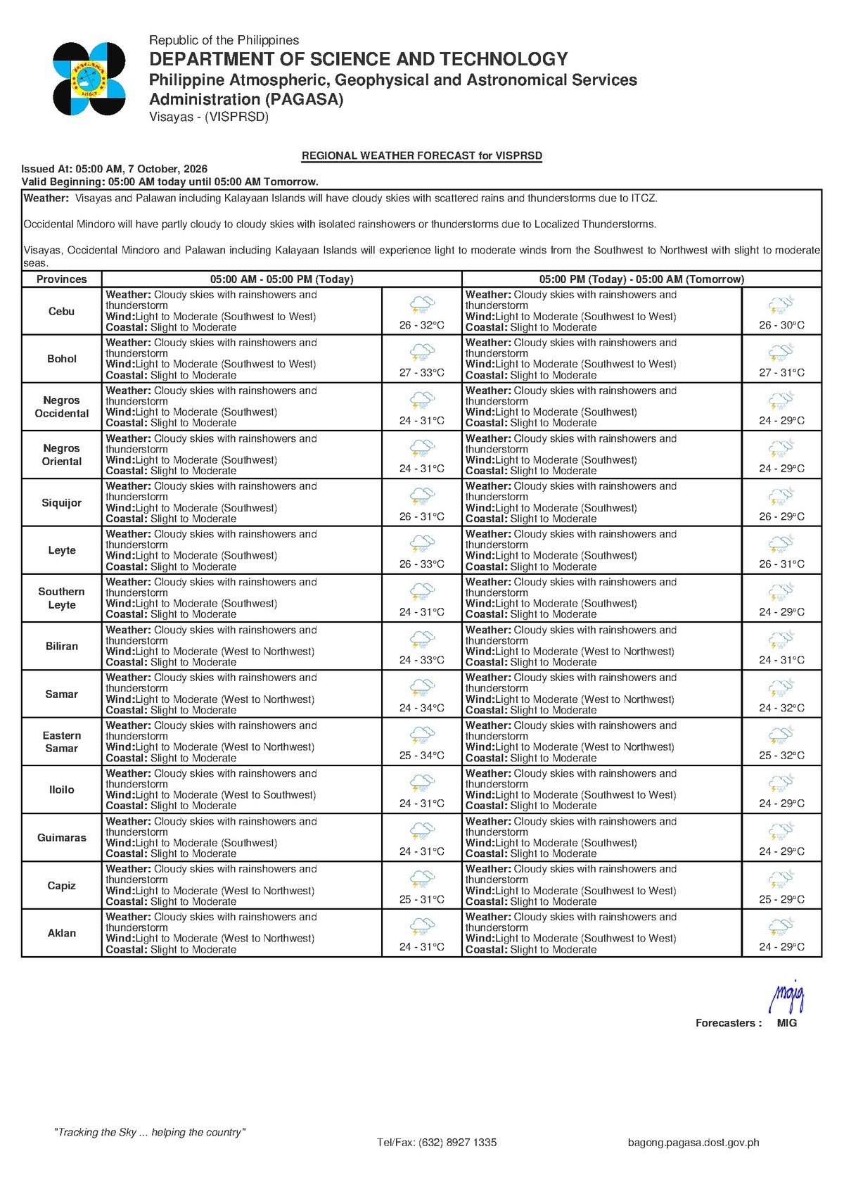
DUMAGUETE CITY, Negros Oriental — October 7, 2026: Wet and unsettled weather is in store for Negros Oriental this Wednesday, with the Philippine Atmospheric, Geophysical and Astronomical Services Administration (PAGASA) forecasting cloudy skies, rainshowers, and thunderstorms across the entire Visayas region. The 5:00 AM bulletin covers areas from Dumaguete down to Guihulngan and extends across the Bohol Sea to Siquijor.
By the Numbers
- Forecast issued at 5:00 AM, Wednesday, October 7, 2026
- Extended outlook issued at 9:00 AM, October 6, 2026
- Temperature range: 26°C (overnight low) to 32°C (daytime high)
- Slight coastal wave heights: approximately 0.5 to 1.25 meters
- Moderate coastal wave heights: approximately 1.25 to 2.5 meters in exposed areas
Southwest Monsoon Driving the Rains
PAGASA’s forecast attributes the wet conditions to winds blowing from the southwest to west — the signature of the southwest monsoon, known locally as habagat. According to PAGASA, this seasonal wind system pulls warm, moisture-heavy air off the sea and into the archipelago. When that humid air rises over land and triggers atmospheric instability, it generates the cloudiness, rainshowers, and thunderstorms currently affecting the Visayas.
Critically, PAGASA’s extended weather outlook — issued at 9:00 AM on October 6, 2026 — indicates that the same southwest-to-west wind pattern will persist through at least Thursday and Friday. The agency’s data suggests this is not a single-day disturbance; the unsettled weather is expected to carry through the remainder of the workweek.
Coverage Across the Province and Region
The forecast from PAGASA applies uniformly across the Visayas, meaning municipalities throughout Negros Oriental — including Bayawan, Bais, Tanjay, Guihulngan, and Mabinay — fall under the same rainy and stormy outlook as Dumaguete City. Siquijor, separated from the province by the Bohol Sea, is likewise under the same weather system with identical risks of cloudiness, rain, and thunderstorms.
Temperatures, PAGASA noted, will stay within a relatively typical Philippine range — a low of 26°C and a high of 32°C — but cloud cover and intermittent rainfall will keep conditions feeling cooler and more humid than the numbers suggest. Thunderstorms, the agency warned, can develop rapidly and bring locally heavy downpours even when broader conditions appear mild.
Sea Conditions and What They Mean on the Water
PAGASA described coastal waters around the region as ranging from slight to moderate. In practical terms, the agency’s classification means the following for those going out to sea:
- Slight conditions correspond to wave heights of roughly 0.5 to 1.25 meters — manageable for large commercial vessels but already choppy for smaller craft.
- Moderate conditions can push wave heights to between 1.25 and 2.5 meters in exposed areas, posing genuine hazards for bancas, motorized outriggers, and non-motorized fishing boats.
Fisherfolk operating out of ports in Dumaguete, Bayawan, Bais, and Siquijor are urged to assess actual sea conditions before departing. If winds pick up or a thunderstorm approaches, PAGASA’s data strongly supports staying ashore.
Inter-Island Ferry and Fast Craft Passengers
Travelers on routes between Dumaguete and Cebu, Siquijor, or other Visayas destinations — including those booked on fast craft services — should be aware that slight to moderate sea states can result in vessel rocking, schedule delays, or operator-initiated cancellations, according to PAGASA’s sea condition classifications. The Philippine Coast Guard retains authority to suspend routes if real-time conditions deteriorate. PAGASA has not issued a gale warning in the current forecast data, meaning large commercial vessels face no formal restriction as of this bulletin — but passengers are advised to confirm schedules directly with their ferry operators before heading to the port, particularly if thunderstorms develop near departure time.
Sector-by-Sector Guidance
Commuters and the General Public
Wet roads are expected throughout Dumaguete and urban centers across Negros Oriental. PAGASA’s forecast of thunderstorms means rain can arrive suddenly and with force — carry proper rain gear, not just a light cover. Anyone outdoors who hears thunder should immediately move into a sturdy structure. Lightning poses serious risk near trees, metal structures, and open areas. Motorcycle riders are especially cautioned on mountain roads toward Valencia, Mabinay, and Guihulngan.
Fisherfolk and Small Boat Operators
Based on PAGASA’s coastal outlook, today is unsuitable for small, lightly built, or non-motorized watercraft. Moderate wave conditions are capable of swamping motorized bancas, and a passing thunderstorm can worsen sea state rapidly. Larger fishing vessels should maintain constant monitoring and return to port if conditions deteriorate. The extended forecast, PAGASA noted, shows these same conditions holding through Thursday and Friday.
Farmers
The rainfall associated with today’s forecast carries both benefit and risk for the agricultural sector. While the moisture can help crops in areas that have been dry, PAGASA’s warning of thunderstorms means the potential for localized flooding in low-lying fields, slope erosion, and wind damage to newly planted or flowering crops. Farmers in Bayawan, Bais, Guihulngan, and Mabinay uplands are advised to check field drainage, secure equipment, and avoid fieldwork when thunderstorms are active.
Students, Parents, and Schools
Children heading to school across Negros Oriental municipalities this Wednesday should be equipped with rain gear, as showers and thunderstorms may occur at any point during school hours — including during afternoon dismissal. Parents are advised to monitor announcements from the Department of Education’s Negros Oriental Division for any class suspension orders. As of PAGASA’s current bulletin, the agency has not signaled conditions that automatically trigger suspensions, though local officials may act based on real-time developments on the ground.
Outdoor Workers and Event Organizers
Construction teams, utility crews, and other outdoor workers should anticipate rain-related work interruptions throughout the day. Community events, markets, and outdoor activities scheduled for Wednesday should have indoor contingency arrangements ready. PAGASA’s thunderstorm forecast means any outdoor activity should be halted and participants moved indoors the moment storm conditions approach.
Outlook Through the Rest of the Week
According to PAGASA’s extended weather outlook issued the previous morning, the southwest-to-west wind pattern driving today’s weather is expected to remain the dominant pattern through at least Thursday and Friday. Residents and businesses across Negros Oriental and the Visayas should plan for continued wet and unsettled conditions rather than anticipating a quick return to dry weather before the weekend.
Why This Matters
PAGASA’s own extended outlook indicates the rainy and unsettled conditions will not be limited to Wednesday — the same weather pattern is expected to persist through Thursday and Friday, meaning disruptions to travel, livelihoods, and outdoor activities could continue across Negros Oriental and the broader Visayas for several consecutive days.
Source: Breaking News Negros Oriental (breakingnewsnegrosoriental.com)