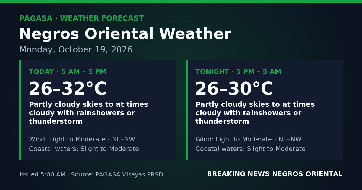
DUMAGUETE CITY, Negros Oriental — October 19, 2026 — Unsettled weather is in store for Negros Oriental this Monday, with the Philippine Atmospheric, Geophysical and Astronomical Services Administration (PAGASA) warning that rainshowers and thunderstorms may occur at any time, both during daylight hours and through the night. The forecast covers the full 24-hour window from 5:00 AM Monday to 5:00 AM Tuesday.
Sky conditions across the province will be partly cloudy to at times cloudy, according to PAGASA — meaning intermittent breaks in cloud cover are expected but do not guarantee dry spells. Shower and thunderstorm cells embedded in the cloud cover can develop and shift quickly, with little advance warning, during both the daytime period (5 AM to 5 PM) and the overnight period (5 PM to 5 AM, Tuesday).
PAGASA’s forecast data for Negros Oriental does not attribute conditions to a specific weather system — such as the northeast monsoon, a low-pressure area, or a shear line — on this date. What is confirmed, however, is that sufficient atmospheric instability and moisture are present to produce convective activity throughout the day and night. PAGASA advised the public to monitor updated bulletins as conditions develop.
Temperature and Humidity
Daytime temperatures will range from a low of 26°C to a high of 32°C. During the overnight period, temperatures will remain between 26°C and 30°C, with cloud cover retaining some surface warmth. PAGASA noted that humidity accompanying showery conditions will make temperatures feel nearer the upper end of those ranges during dry intervals, making hydration and shade important for people working or moving outdoors through the afternoon.
Winds and Sea Conditions
Winds over Negros Oriental are forecast by PAGASA as light to moderate, blowing from the northeast to northwest, for both the daytime and overnight periods. Coastal waters — including the Tañon Strait between Negros and Cebu, and the channels off Dumaguete and between the province and Siquijor — are described as slight to moderate.
PAGASA’s sea-state classifications carry practical meaning for mariners:
- Slight seas involve wave heights of roughly 0.5 to 1.25 metres — manageable for larger vessels but already a factor for small bancas and outrigger fishing boats.
- Moderate seas involve wave heights that can reach approximately 1.25 to 2.5 metres — conditions that challenge even inter-island ferries and pose real risk to small watercraft.
Because the forecast range extends to moderate, small-boat operators fishing off Bayawan, the waters near Bais, or the channel toward Siquijor are advised to exercise caution before heading out. During thunderstorm episodes, winds and seas can temporarily exceed the general forecast range.
Passengers booked on inter-island routes — including fast-craft services linking Dumaguete to Cebu, Siquijor, and Dapitan — should confirm departure status with their respective shipping lines before travelling. PAGASA and Philippine Coast Guard guidance should be followed at all times.
Active Warnings as of 5:00 AM
As of PAGASA’s 5:00 AM issuance, no tropical cyclone wind signals, gale warnings, or color-coded rainfall advisories are in effect specifically for Negros Oriental. No active tropical cyclone warning is affecting the province based on available PAGASA source data.
PAGASA’s inclusion of thunderstorms in the forecast nonetheless warrants caution. Thunderstorms can produce sudden intense rainfall over short periods, leading to flash flooding in low-lying barangays, overflow in rivers and drainage channels, and lightning hazards — even in the absence of a formal rainfall warning. Residents in flood-prone areas of Dumaguete City, Guihulngan, and municipalities along river systems are advised to stay alert during any thunderstorm episode.
Guidance by Sector
Commuters and Motorists
Roads across the province can transition from dry to slippery within minutes when a rain cell passes through. Extra travel time is advisable, particularly during the afternoon when convective thunderstorm development is most likely. Flooded roads and underpasses should be avoided during heavy rain episodes, even where floodwaters appear shallow, as levels can rise rapidly.
Fisherfolk and Small-Boat Operators
With coastal waters ranging up to moderate and thunderstorms possible, banca and small-boat operators face added risk today. Squalls accompanying thunderstorms can produce gusts stronger than the general wind forecast. Anyone already at sea who observes a developing thunderstorm — characterised by dark, towering clouds and lightning — should return to port or seek shelter without delay.
Farmers
While rainfall through the day and overnight can benefit crops, prolonged thunderstorm activity may cause waterlogging in low-lying fields, particularly in agricultural municipalities such as Guihulngan in the north and Bayawan and Santa Catalina in the south. PAGASA’s forecast also makes pesticide or fertiliser application inadvisable on days when rain is imminent, as runoff reduces effectiveness and may affect nearby waterways.
Students, Parents, and Schools
Parents should equip children with rain gear for the school day. While the current forecast does not indicate the kind of severe weather that would typically prompt class suspensions, sudden heavy rain from a thunderstorm can make travel difficult. The Department of Education Division office and local government units should be monitored for any advisories throughout the day.
Outdoor Workers and Event Organisers
Physically demanding outdoor tasks are best scheduled for early morning, before afternoon convective heating increases the probability of thunderstorm development. Those with outdoor events planned for Monday evening in Dumaguete or elsewhere in the province should prepare contingency arrangements, as PAGASA’s forecast carries the possibility of rainshowers and thunderstorms through the overnight period as well.
Overnight Outlook
PAGASA’s forecast provides no clear period overnight. From 5:00 PM Monday through 5:00 AM Tuesday, the same pattern of partly cloudy to at times cloudy skies, with rainshowers and thunderstorms possible, continues to apply across Negros Oriental.
Source: breakingnewsnegrosoriental.com / PAGASA