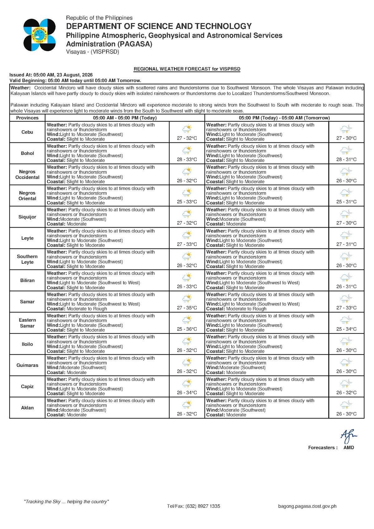
DUMAGUETE CITY, Negros Oriental — The Philippine Atmospheric, Geophysical and Astronomical Services Administration (PAGASA) is warning residents across Negros Oriental and the Visayas to brace for an unsettled Sunday, August 23, 2026, as its early-morning bulletin points to partly cloudy to overcast skies with intermittent rainshowers and possible thunderstorms throughout the day. The state weather bureau released its Visayas regional forecast at 5:00 AM, covering a broad swath of Central Visayas that includes Dumaguete City, Bayawan, Bais, Guihulngan, the island province of Siquijor, Cebu, and adjacent sub-regions in Eastern Visayas.
PAGASA reported that temperatures for the day will hover between 27°C and 32°C — warm but accompanied by significant humidity that could make conditions feel considerably hotter, especially at peak afternoon hours. The wind is blowing in from the southwest at light to moderate speeds, while coastal waters around the province are classified as slight to moderate. Though these conditions do not signal a severe weather event, the combination of monsoon-driven moisture and afternoon atmospheric heating means that quiet mornings can rapidly give way to heavy downpours and electrical storms.
By the Numbers
- Forecast issued at: 5:00 AM, Sunday, August 23, 2026
- Temperature range: 27°C to 32°C (rising to as high as 34°C per the extended outlook)
- Extended outlook issued at: 9:00 AM, August 22, 2026
- Coastal wave heights (slight to moderate): approximately 0.5 to 2.5 meters
- Wind speed range (light to moderate): approximately 10 to 40 kilometers per hour
The Weather Driver: Southwest Monsoon
According to PAGASA, the primary force behind today’s wet and unstable conditions is the southwest monsoon, known locally as habagat. This seasonal weather system typically dominates the Philippine archipelago from June through September, pushing warm, moisture-saturated air from the southwest across the country. As the habagat sweeps over the warm waters of the Sulu Sea and Visayan Sea before making landfall over Negros Oriental and the rest of the Visayas, it accumulates vast amounts of moisture. When that moisture-heavy air rises over elevated terrain or collides with atmospheric disturbances, it fuels the cloud formation, showers, and thunderstorm activity that PAGASA is forecasting for today.
The state weather bureau noted that this pattern is typical and expected for the Visayas at this time of year. However, PAGASA emphasized that thunderstorm development in the afternoon — when surface temperatures are at their peak and atmospheric instability is greatest — still demands public vigilance even when conditions are not classified as extreme.
Conditions Across Negros Oriental and Central Visayas
PAGASA’s forecast describes the sky condition today as partly cloudy to at times cloudy. In practical terms, residents can expect periods of sunshine interspersed with thickening cloud cover and rainfall that may not be continuous but can develop with little warning. The most critical window for thunderstorm activity, according to standard PAGASA forecasting guidelines, is during the afternoon and early evening when heat accumulation in the lower atmosphere peaks.
Among the areas specifically noted in PAGASA’s bulletin are Dumaguete City, the Negros Oriental provincial capital; coastal cities of Bayawan and Bais; Guihulngan City in the province’s northern corridor; and the island province of Siquijor. PAGASA’s Visayas regional bulletin also covers Cebu and the broader Central and Eastern Visayas areas under the same general weather advisory.
An extended weather outlook issued by PAGASA at 9:00 AM on August 22, 2026 indicates that similar conditions are projected to persist through the weekend and into Monday. That extended forecast also shows daytime temperatures climbing slightly higher — reaching up to 34°C on Saturday and Sunday — while wind direction and coastal sea states remain largely unchanged, signaling that the southwest monsoon’s grip on the region is not expected to relax in the near term.
Understanding the Forecast Details
Sky condition — Partly cloudy to at times cloudy with rainshowers or thunderstorms: PAGASA’s phrasing signals an on-and-off pattern rather than sustained rainfall. Mornings may be relatively dry, giving a false sense of security. Thunderstorms, however, can build rapidly in the afternoon, often with little advance warning. Residents should not interpret a dry start to the day as clearance that rain will not come.
Temperature of 27°C to 32°C: The lower figure reflects cooler early-morning or overnight readings, while the upper figure marks peak midday heat. Combined with the high relative humidity typical of habagat conditions, the heat index — or “feels like” temperature — may register significantly above the measured 32°C. PAGASA routinely advises the public to stay hydrated and limit prolonged outdoor exposure during peak afternoon heat.
Wind from the southwest at light to moderate speeds (roughly 10 to 40 km/h): These wind speeds are unlikely to cause structural damage or uproot trees on land, but they are strong enough to generate choppy conditions at sea. Residents near the coast and inter-island ferry passengers should take note.
Coastal condition — Slight to moderate (wave heights approximately 0.5 to 2.5 meters): Larger commercial vessels generally operate within these parameters, but PAGASA’s classification places small watercraft operators — including banca fishermen and small outrigger boat users — at elevated risk. These operators are advised to carefully assess actual sea conditions before departing and to remain aware that a passing thunderstorm can quickly worsen conditions beyond forecast averages.
Guidance for Different Groups
Ferry Passengers and Inter-Island Travelers
Those planning to travel by sea — including on routes between Dumaguete and Cebu or between the Negros Oriental mainland and Siquijor — should check with their ferry operators before heading to the port. Shipping lines such as OceanJet and other inter-island carriers routinely adjust or cancel departures when sea conditions deteriorate. While slight to moderate coastal waters and light to moderate winds should allow most regular services to proceed, PAGASA’s forecasted thunderstorms could rapidly alter conditions along open straits. Passengers are advised to monitor official announcements from operators and the Philippine Coast Guard.
Fisherfolk and Small Boat Operators
PAGASA’s slight to moderate coastal classification means fishing activity is possible but should be approached with caution. Southwest winds can generate more pronounced swells on the windward side of Negros Oriental compared to sheltered coastal stretches. Critically, fishermen and small boat operators are reminded that lightning over open water represents one of the most dangerous hazards associated with a thunderstorm. PAGASA and maritime safety authorities consistently advise that fishing vessels return to port well before any visible storm approaches. Always inform someone onshore of your departure point, destination, and expected return time.
Farmers and Agricultural Workers
For the province’s farming communities — including growers of sugarcane, rice, and vegetables across Negros Oriental’s hills and coastal flatlands — intermittent rain is generally beneficial for soil moisture during dry spells. However, PAGASA warns that sudden heavy downpours associated with thunderstorms can trigger localized flooding and soil erosion on sloped land. The state weather bureau advises farmers to secure harvested produce and postpone fertilizer or pesticide applications on days when significant rainfall is forecast, as rain can wash these inputs away before they are absorbed.
Commuters, Students, and Outdoor Workers
Motorcycle riders — a predominant form of transport across Negros Oriental — should carry rain gear at all times today. Roads can become slippery within minutes of a downpour beginning, and visibility drops sharply during thunderstorms. Outdoor event organizers, construction crews, and road workers are advised by PAGASA guidelines to monitor sky conditions continuously and to suspend outdoor activities and seek shelter immediately upon hearing thunder or seeing lightning, regardless of how far away the storm appears to be.
Why This Matters
PAGASA’s forecast of rainshowers and possible thunderstorms driven by the southwest monsoon directly affects a wide range of daily activities across Negros Oriental and the broader Visayas region — from maritime travel and fishing livelihoods to agriculture and public safety. The projected temperature rise to 34°C in the extended outlook, combined with ongoing monsoon humidity, raises real concerns about heat stress for outdoor workers and vulnerable populations. Accurate awareness of PAGASA’s official advisories allows residents, commuters, farmers, and maritime operators to make informed, timely decisions that can prevent weather-related injuries, property damage, and loss of life.
Source: Breaking News Negros Oriental (breakingnewsnegrosoriental.com), citing PAGASA Visayas regional forecast issued August 23, 2026.