DUMAGUETE CITY — A wet and unsettled Monday is in store for Negros Oriental and the rest of the Visayas, as the southwest monsoon continues to push moisture-laden air across the Philippine archipelago. The Philippine Atmospheric, Geophysical and Astronomical Services Administration (PAGASA) has signaled rainshowers and thunderstorms for the region throughout August 24, 2026, urging residents — particularly those at sea or working outdoors — to take precautions.
The Forecast at a Glance
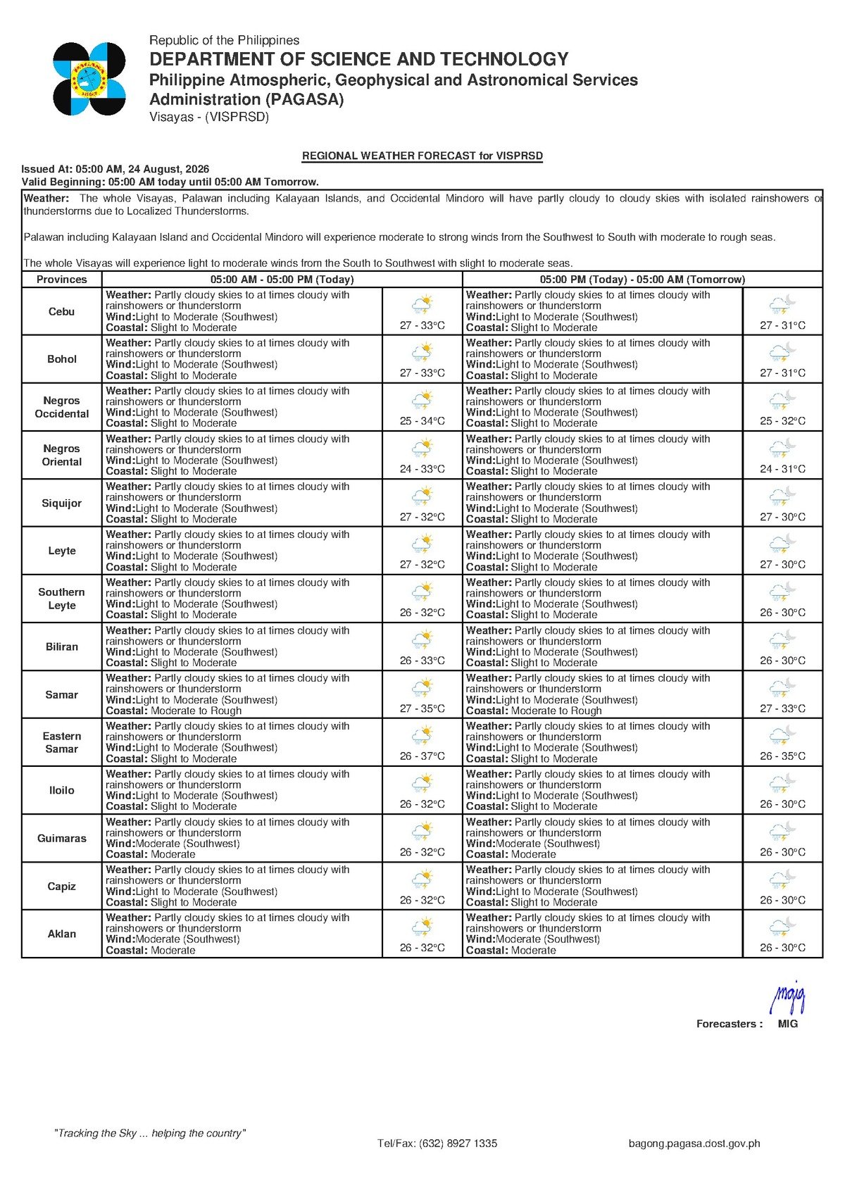
According to PAGASA’s Visayas Regional Forecast, issued at 5:00 AM on Monday, August 24, 2026, skies over the region will be partly cloudy to at times cloudy, with intermittent rainshowers and the potential for thunderstorms developing at any point during the day. For Negros Oriental, PAGASA reported temperatures ranging from a low of 27°C to a high of 33°C. Winds are blowing in from the southwest at light to moderate speeds, while coastal waters across the area have been rated slight to moderate.
PAGASA’s extended weather outlook, issued earlier at 9:00 AM on August 23, 2026, indicates that this general weather pattern is not expected to clear quickly. The agency’s projections for the days following Monday also show southwest winds, partly cloudy to cloudy skies, and slight to moderate seas — pointing to a sustained monsoon regime rather than a brief weather disturbance.
By the Numbers
- Forecast low temperature for Negros Oriental: 27°C
- Forecast high temperature for Negros Oriental: 33°C
- Extended outlook temperature range (coming days): 27°C to 32°C
- PAGASA morning forecast issuance time: 5:00 AM, August 24, 2026
- Extended outlook issuance time: 9:00 AM, August 23, 2026
The Southwest Monsoon Behind the Weather
The culprit behind today’s unsettled conditions, PAGASA confirmed, is the southwest monsoon — known locally as habagat. This seasonal wind system draws warm, moisture-saturated air from the Indian Ocean and the South China Sea into the Philippine archipelago, typically dominating weather patterns from June through October each year. When the habagat is in full swing, persistent cloudiness, afternoon showers, and sudden thunderstorms become the norm — particularly across the Visayas island group.
In practical terms, the warm and humid air mass moving over Negros Oriental rises as it meets land, cools at altitude, and condenses into rain clouds. This mechanism is why PAGASA is not merely forecasting ordinary drizzle, but potential thunderstorms — episodes of intense, concentrated rainfall accompanied by lightning and sudden wind gusts. The agency noted that mornings may begin with relatively fair weather, only for conditions to deteriorate as the day progresses into the afternoon hours when storm cells are most likely to form.
Conditions Across the Region
For communities throughout Negros Oriental — including Dumaguete City, Bayawan, Bais, Guihulngan, and interior municipalities — PAGASA’s forecast points to an on-and-off rain day with no extended dry spells guaranteed. The temperature ceiling of 33°C means that intervals between rain episodes will feel hot and humid, particularly in urban areas and low-lying zones.
The same southwest monsoon pattern affects the neighboring island province of Siquijor. Residents there and those with planned travel across the Siquijor Strait should account for the possibility of passing squalls during the day. PAGASA’s forecast covers the broader Visayas region uniformly, meaning Cebu, Bohol, and the provinces of Eastern and Western Visayas are all under the same partly cloudy to cloudy, shower-prone conditions.
Coastal and Maritime Safety
PAGASA’s coastal condition rating of “slight to moderate” for Monday means that wave heights remain within generally manageable ranges for large commercial vessels and passenger ferries under normal operating conditions. However, the agency’s forecast does not eliminate risk for smaller watercraft.
PAGASA confirmed that no gale warning has been issued for the area as of the 5:00 AM forecast, meaning sustained strong winds are not the primary hazard. The greater danger for small boat operators comes instead from the localized, sudden wind gusts that accompany developing thunderstorm cells — conditions that can capsize or swamp a small vessel rapidly, even when the broader coastal rating appears manageable.
For fisherfolk and operators of small motorized boats and bangka, PAGASA’s forecast effectively advises going out early while conditions are still relatively calm, staying close to the shoreline, watching for rapidly building dark clouds on the horizon, and returning to port immediately at the first sign of an approaching thunderstorm. Waiting until a storm arrives before heading back is not a safe option.
Passengers booked on inter-island fast craft and ferry routes — including services between Dumaguete and Siquijor, and Dumaguete and Cebu — are advised to check with their operators for any schedule adjustments before heading to the port. While PAGASA has not flagged extreme conditions, fast-craft services can be temporarily suspended or modified when thunderstorms move directly over ferry lanes. Confirming departure times in advance and allowing for extra travel time is strongly recommended.
Guidance for Key Groups
Students and Daily Commuters
Students, parents, and commuters in Dumaguete City and other urban centers in Negros Oriental should keep rain gear within easy reach throughout the day. PAGASA’s forecast suggests showers that may arrive suddenly rather than follow a predictable schedule. Afternoon hours — coinciding with school dismissal times — are a particular window of concern, as thunderstorm activity in the Visayas tends to peak during the late afternoon under active habagat conditions.
Farmers and Agricultural Workers
For farmers in Negros Oriental’s sugarcane, vegetable, and rice-growing municipalities, Monday’s forecast carries both benefit and risk. The rainfall can provide necessary moisture for crops currently in the growing season. At the same time, PAGASA’s warning of possible thunderstorms and gusty winds means that standing crops could sustain damage, and newly planted seedlings are vulnerable to runoff. Open-field work should be suspended during active lightning periods, and any harvested or drying crops left in the open should be moved under shelter before afternoon, when storm activity is most likely to intensify.
Outdoor and Construction Workers
Workers in construction, infrastructure maintenance, and other outdoor sectors should be prepared to halt operations when thunderstorms develop. Lightning poses a genuine occupational hazard during active storm episodes. PAGASA’s forecast makes clear that thunderstorm development is a real possibility at various points throughout the day, not merely an overnight risk. Supervisors should ensure clear protocols are in place for moving personnel to safe shelter when thunder is audible or lightning is visible.
Tourists and Travelers
Visitors to tourist sites in Negros Oriental — including the Dumaguete waterfront, Apo Island, the Manjuyod sandbar, and Twin Lakes — as well as those planning trips to Siquijor should pack rain gear and keep itineraries flexible. Water- and boat-based activities remain generally possible but can be interrupted quickly as conditions shift. Tourists are urged to follow the guidance of local operators and guides, especially for sea-based excursions.
What the Week Ahead Looks Like
According to PAGASA’s extended outlook issued on August 23, 2026, the southwest monsoon pattern over the Visayas is expected to persist into the coming days. Both the days immediately following Monday show projections of 27°C to 32°C temperatures, light to moderate southwest winds, and slight to moderate coastal conditions — indicating that residents and businesses should plan for a consistently wet week rather than isolated rain events.
PAGASA advises the public to treat the current period as a sustained habagat phase, with day-to-day variability in rainfall intensity depending on how active the monsoon flow is on any given morning. Monitoring PAGASA’s daily bulletins for updated forecasts remains the most reliable way to plan activities for the days ahead.
Why This Matters
The southwest monsoon’s sustained influence over Negros Oriental and the broader Visayas means that intermittent thunderstorms and wet conditions are not a passing event but an ongoing weather regime lasting at least through the coming week, according to PAGASA. For coastal communities and fisherfolk, the combination of slight-to-moderate seas and sudden thunderstorm-generated wind gusts poses a real safety risk that goes beyond what broad coastal condition ratings alone convey. Agricultural workers, commuters, students, and inter-island travelers all face practical disruptions that require advance planning and close monitoring of PAGASA’s daily updates.
Source: Breaking News Negros Oriental (breakingnewsnegrosoriental.com) / PAGASA Visayas Regional Forecast, August 24, 2026