DUMAGUETE CITY — Southwest winds carrying moisture-laden air are setting the stage for an unsettled Thursday across Negros Oriental, with the Philippine Atmospheric, Geophysical and Astronomical Services Administration (PAGASA) warning of rainshowers, cloud buildup, and the real possibility of thunderstorms throughout the day on August 20, 2026. The agency issued its Regional Forecast at 5:00 AM on August 19 and followed it with an Extended Weather Outlook at 9:00 AM the same morning, together providing a clearer picture of what residents, commuters, fisherfolk, and farmers should prepare for.
Thursday’s Weather at a Glance
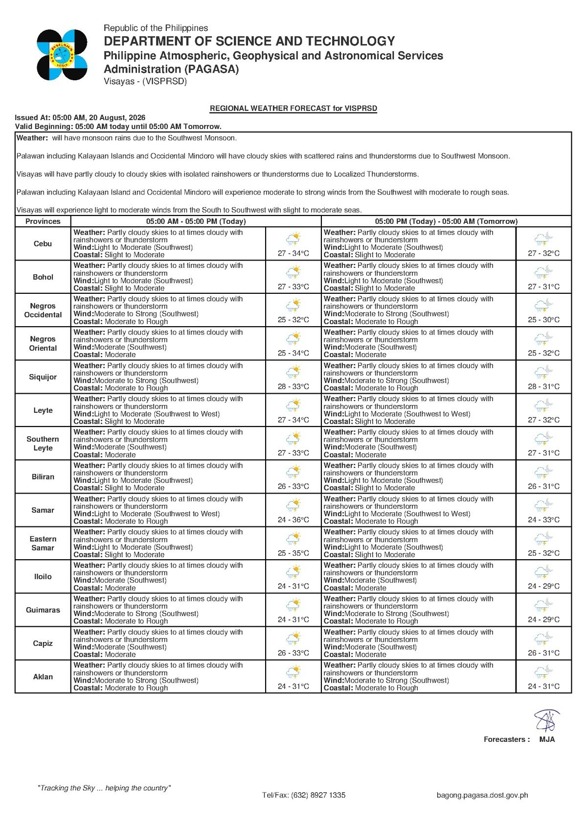
PAGASA describes Thursday’s sky conditions over the Visayas — including Negros Oriental — as partly cloudy to at times cloudy, with rainshowers and thunderstorms expected to develop during the day. Cities and municipalities across the province, among them Dumaguete, Bayawan, Bais, and Guihulngan, as well as the neighboring island of Siquijor, all fall under the same forecast umbrella.
Any clear spells in the early hours should not be taken as a sign that the day will stay dry. According to PAGASA’s bulletin, clouds are expected to thicken and rain to follow, with thunder and lightning occurring at certain points throughout the day. Temperatures will range from a low of 27°C to a high of 33°C. That upper figure, paired with the August humidity characteristic of the Visayas, will make any rain-free intervals feel warm and muggy.
Winds are blowing in from the southwest at moderate speeds, and PAGASA has rated coastal waters across the region as moderate in condition.
By the Numbers
- Forecast low temperature: 27°C
- Forecast high temperature: 33°C
- PAGASA Regional Forecast issued: 5:00 AM, August 19, 2026
- PAGASA Extended Weather Outlook issued: 9:00 AM, August 19, 2026
What Is Causing the Unsettled Conditions
No named tropical cyclone, low-pressure area, or formal storm signal has been assigned to Negros Oriental or the broader Visayas under this particular forecast, PAGASA’s regional bulletin confirms. Rather, it is the prevailing southwest monsoon pattern — typical of Philippine weather between June and September — that is the primary driver behind the scattered showers and convective activity.
Southwest winds during this period routinely carry moisture from the western side of the archipelago into the Visayas, fueling the kind of afternoon thunderstorm development that locals know well. PAGASA’s data notes that while Tropical Cyclone Bulletins and a Tropical Cyclone Warning for Shipping are currently active at the national level, no cyclone wind signal has been placed over this province or region under the current forecast. Nevertheless, the weather agency advises residents to keep monitoring its official channels, as conditions can shift during the course of the day.
Risk Areas: Urban Flooding, Coastal Hazards, and River Communities
In Dumaguete City — the provincial capital and the region’s main transport and commercial hub — periods of heavier rainfall could trigger temporary flooding in low-lying streets, particularly along coastal zones and in flood-prone barangays. The same concern applies to Bayawan City in the south and Bais City to the north. In Guihulngan City, the interior terrain can channel runoff into communities situated along river systems, making drainage monitoring especially important during intense downpours.
On Siquijor island, located just across the Mindanao Sea from Dumaguete, conditions mirror those of the mainland province: partly cloudy to cloudy skies, rainshowers and thunderstorms, southwest winds at moderate speeds, and moderate coastal seas. Anyone planning inter-island travel — whether to Siquijor, Cebu, Bohol, or other Visayas destinations — should factor the weather situation into their scheduling before leaving for the port.
Understanding “Moderate” Coastal Conditions
PAGASA’s designation of coastal waters as moderate carries practical meaning for anyone whose work or travel takes them onto the sea. Under moderate conditions, seas are rough enough to pose a genuine hazard to small and motorized bancas, even if larger commercial vessels can continue under normal operations. When thunderstorms enter the picture, the risk level rises further: localized squalls linked to convective activity can generate sudden, intense gusts that catch small-boat operators off guard even in the absence of a formal gale warning.
PAGASA has not issued a gale warning for coastal waters in Negros Oriental or the Visayas under this forecast cycle. However, the weather agency’s standing maritime guidance makes clear that small seacraft — bancas, outrigger fishing boats, and similar vessels — should avoid open water whenever thunderstorms are in the forecast. Squalls associated with thunderstorm cells can develop rapidly and pose life-threatening conditions before an operator can safely return to shore.
Practical Guidance for Specific Groups
Ferry Passengers and Inter-Island Travelers
Those booked on fast craft or ferry services — including routes connecting Dumaguete to Siquijor, Cebu, and Bohol operated by OceanJet and other carriers — are advised to check with their shipping line before heading to the terminal. While no gale warning is currently in effect, moderate sea conditions combined with the risk of thunderstorm-driven squalls can prompt operators to adjust or cancel departures on short notice. Allow extra time in your travel plans and stay reachable for schedule updates.
Fisherfolk and Small-Boat Operators
The overlap of moderate coastal seas and possible thunderstorms raises the risk level for fishing activities in waters around Negros Oriental. PAGASA’s data suggests that venturing far offshore on Thursday carries an elevated danger. Fishermen who must go out are urged to remain close to the coastline, watch for early warning signs such as darkening skies and rising winds, and inform someone onshore of their departure and expected return time before setting out.
Farmers Across the Province
Wet field conditions are the expected reality for farmers on Thursday, whether they are tending sugarcane, rice paddies, or vegetable plots. Saturated soil will make heavy farm machinery difficult to maneuver, and low-lying crops could face waterlogging risk if thunderstorm rainfall is especially heavy. PAGASA’s extended weather outlook suggests similar wet conditions will continue into Friday, so farm managers should sequence their tasks accordingly and avoid remaining in open fields during active thunderstorm periods because of lightning risk.
Students, Parents, and School Administrators
Children heading to school on Thursday should be sent with rain gear — at minimum an umbrella or waterproof jacket. School officials in flood-prone areas are encouraged to watch rainfall intensity through the morning and midday hours. PAGASA has not issued a specific advisory calling for class suspensions as of this bulletin, but weather conditions remain dynamic and local decision-makers should be prepared to act if rainfall becomes heavy and sustained.
Outdoor Workers and Event Organizers
Workers in construction, road maintenance, agriculture, and other exposed occupations should schedule the most critical or safety-sensitive tasks during the earlier hours of the morning, when conditions may be relatively drier. Identified shelter locations should be pre-planned and accessible throughout the workday. Event organizers with outdoor activities planned for Thursday are advised to prepare contingency arrangements, including postponement options, in case thunderstorms materialize during peak hours.
Why This Matters
The combination of thunderstorm potential and moderate coastal seas poses concrete safety risks for maritime workers, fisherfolk, and inter-island passengers who depend on sea routes linking Negros Oriental to neighboring islands. Wet and potentially flooded conditions in urban and agricultural areas affect daily movement, livelihoods, and school attendance across the province. PAGASA’s guidance underscores that even in the absence of a named storm or formal wind signal, prevailing monsoon-driven weather can create genuinely dangerous situations on land and at sea that require active precaution.
Source: PAGASA Regional Forecast and Extended Weather Outlook, August 19, 2026, as reported by Breaking News Negros Oriental (breakingnewsnegrosoriental.com)