A combination of a distant tropical storm’s outer weather system and Pacific-driven winds will bring unsettled conditions to multiple parts of the Philippines on Saturday, June 20, 2026, with the highest threat levels concentrated in Eastern Visayas and the northeastern edge of Mindanao. The Philippine Atmospheric, Geophysical and Astronomical Services Administration (PAGASA) released its 24-hour public weather forecast at 4:00 AM Saturday, covering conditions through 4:00 AM on Sunday, June 21.
Three weather systems are at play, according to PAGASA: the trough of Tropical Storm Mekkhala affecting the eastern portions of Visayas and Mindanao, easterlies — moisture-laden Pacific winds — influencing Central and Southern Luzon, and localized thunderstorm activity producing scattered showers across the rest of the archipelago.
Tropical Storm Mekkhala: Distant But Already Felt
At 3:00 AM Saturday, Tropical Storm Mekkhala (international designation 2607) was positioned at approximately 14.3°N, 138.4°E, placing it roughly 1,665 kilometers east of southeastern Luzon — well outside the Philippine Area of Responsibility. PAGASA reported the storm is packing maximum sustained winds of 75 km/h near its center, with gusts of up to 90 km/h, and is tracking west-northwestward at a speed of 25 km/h.
No tropical cyclone wind signal has been hoisted over any part of the country, PAGASA confirmed. Despite Mekkhala’s considerable distance, however, its trough — a low-pressure extension that radiates outward from the cyclone’s core — is already generating rainfall across portions of Eastern Visayas and the northeastern tip of Mindanao. The agency advised residents in affected areas to continue monitoring official weather bulletins, as the storm’s trajectory could bring it closer to the Philippines over the next several days.
Luzon: Pacific Winds Stir Isolated Showers and Thunderstorms
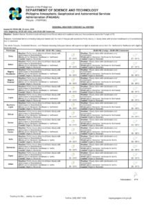
Across most of Luzon, Saturday’s weather will be governed by easterlies — winds originating from the Pacific Ocean that carry substantial moisture inland. PAGASA forecasts partly cloudy to cloudy skies with isolated rainshowers or thunderstorms for the following areas:
- Metro Manila
- Central Luzon — Pampanga, Bulacan, Tarlac, Nueva Ecija, Bataan, Zambales, and Aurora
- CALABARZON — Cavite, Laguna, Batangas, Rizal, and Quezon
- MIMAROPA — Marinduque, Occidental Mindoro, Oriental Mindoro, Palawan, and Romblon
- Bicol Region — Albay, Camarines Norte, Camarines Sur, Catanduanes, Masbate, and Sorsogon
Although rain is not forecast to be continuous throughout the day, PAGASA cautioned that intense thunderstorm bursts could still produce flash floods or landslides in low-lying communities, areas near riverbanks, and zones with steep terrain. Residents in the Bicol Region and the Pacific-facing portions of CALABARZON are considered especially susceptible given their geographic exposure to easterly weather patterns.
In Metro Manila specifically, winds are expected to blow from the northeast to southeast at light to moderate speeds. Coastal waters surrounding Luzon are forecast to be slight to moderate, with wave heights ranging between 0.6 and 1.2 meters — generally manageable for small sea vessels, though standard maritime precautions remain advisable, PAGASA noted.
Visayas: Eastern Provinces Face Elevated Landslide and Flood Risk
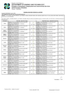
The Visayas region presents the most pressing weather concern outside of Mindanao’s eastern provinces on Saturday. According to PAGASA, the trough of Tropical Storm Mekkhala is directly influencing the eastern sections of the region, driving cloudy skies with scattered rains and thunderstorms over:
- Eastern Samar
- Southern Leyte
These two provinces carry the highest risk designation in the forecast period. PAGASA explicitly warned of the potential for flash floods and landslides owing to moderate to at times heavy rainfall. Communities situated along mountain slopes or in low-lying coastal barangays within these provinces are urged to remain on high alert and to comply immediately with any evacuation directives issued by local government units.
The remainder of the Visayas — spanning Western Samar, Cebu, Bohol, Negros, Iloilo, Capiz, Aklan, Antique, and Guimaras — will experience partly cloudy to cloudy conditions with isolated showers or thunderstorms fueled by localized weather activity. Even in these areas, PAGASA noted that severe thunderstorm episodes could still trigger localized flash floods or landslides.
Coastal sea conditions across the Visayas are forecast to be slight to moderate, with wave heights between 0.6 and 1.5 meters under light to moderate northeast to northwest winds.
Mindanao: Northeast Provinces Under Alert, Western Areas See Light Showers
Mindanao’s weather on Saturday is divided along an east-west axis. The trough of Tropical Storm Mekkhala continues to affect the eastern section of the island group, with the most significant impacts expected in:
- Dinagat Islands
- Surigao del Norte
These provinces are placed under the same elevated risk category as Eastern Samar and Southern Leyte, with PAGASA forecasting cloudy skies, scattered rains, and thunderstorms alongside a clear risk of flash floods or landslides from moderate to occasionally heavy rainfall. PAGASA highlighted that Surigao del Norte has a documented history of flood vulnerability during periods of enhanced rainfall linked to tropical weather disturbances.
The rest of Mindanao — including Davao Region, Northern Mindanao, the Zamboanga Peninsula, SOCCSKSARGEN, and the Bangsamoro Autonomous Region in Muslim Mindanao (BARMM) — is expected to see partly cloudy to cloudy skies with isolated rainshowers or thunderstorms produced by localized convective activity. Flash flood and landslide risks persist during heavy thunderstorm episodes in these areas as well, according to PAGASA.
Along Mindanao’s eastern coast, sea conditions are forecast at slight to moderate with wave heights of 0.6 to 1.5 meters under light to moderate northeast to northwest winds. In the western portions of Mindanao, southwest to west winds will prevail at light to moderate intensities, with wave heights of 0.6 to 1.2 meters.
Temperature, Tides, and Astronomical Data for Saturday
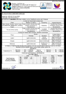
Weather instruments at PAGASA’s Science Garden station in Diliman, Quezon City recorded a maximum temperature of 33.1°C at 11:00 AM on Friday and a minimum of 26.5°C at 6:00 AM. Relative humidity readings spanned from a peak of 89% down to 57%, characteristic of the warm, muggy conditions that define the Philippine wet season in June, PAGASA reported.
For Metro Manila on Saturday, sunrise is at 5:28 AM and sunset at 6:27 PM. The moon rises at 10:28 AM and sets at 11:04 PM, with a 35% illumination — a waxing crescent phase offering only minimal natural lighting after dark.
Tidal data sourced from the National Mapping and Resource Information Authority (NAMRIA) for Manila Bay indicates a high tide of 1.29 meters at 1:41 PM and a low tide of 0.04 meters at 10:03 PM. NAMRIA’s data is particularly relevant for coastal communities around Manila Bay, where the convergence of heavy rain and high tide levels can worsen localized flooding conditions.
Key Safety Guidelines for June 20
Based on its 24-hour forecast, PAGASA highlighted the following safety priorities for Saturday:
- Residents of Eastern Samar, Southern Leyte, Dinagat Islands, and Surigao del Norte face the greatest risk and are advised to keep away from riverbanks, steep hillsides, and other areas prone to landslides whenever rain intensifies.
- Households in Metro Manila and neighboring provinces should anticipate brief but potentially strong rain bursts capable of causing street flooding, and are urged to stay updated on PAGASA’s hourly weather updates.
- Fisherfolk and mariners across the archipelago are reminded to observe standard sea safety protocols, particularly along the eastern seaboards of Visayas and Mindanao where wave conditions are less favorable.
- All residents nationwide are encouraged to avoid unnecessary travel to flood-prone or mountainous zones during periods of active rainfall, and to keep emergency contact numbers accessible.
PAGASA reaffirmed that the public should rely on official agency bulletins and local government announcements for the most current advisories throughout the day, as weather conditions may change rapidly in relation to Tropical Storm Mekkhala’s evolving track.
Originally reported by: wire reports