Tropical Depression Luis crept nearly to a standstill over the sea east of Aurora on Monday morning, August 3, 2026, as weather authorities placed wide portions of Northern and Central Luzon under a wind signal and warned the public that landfall could occur before dawn on Tuesday, August 4.
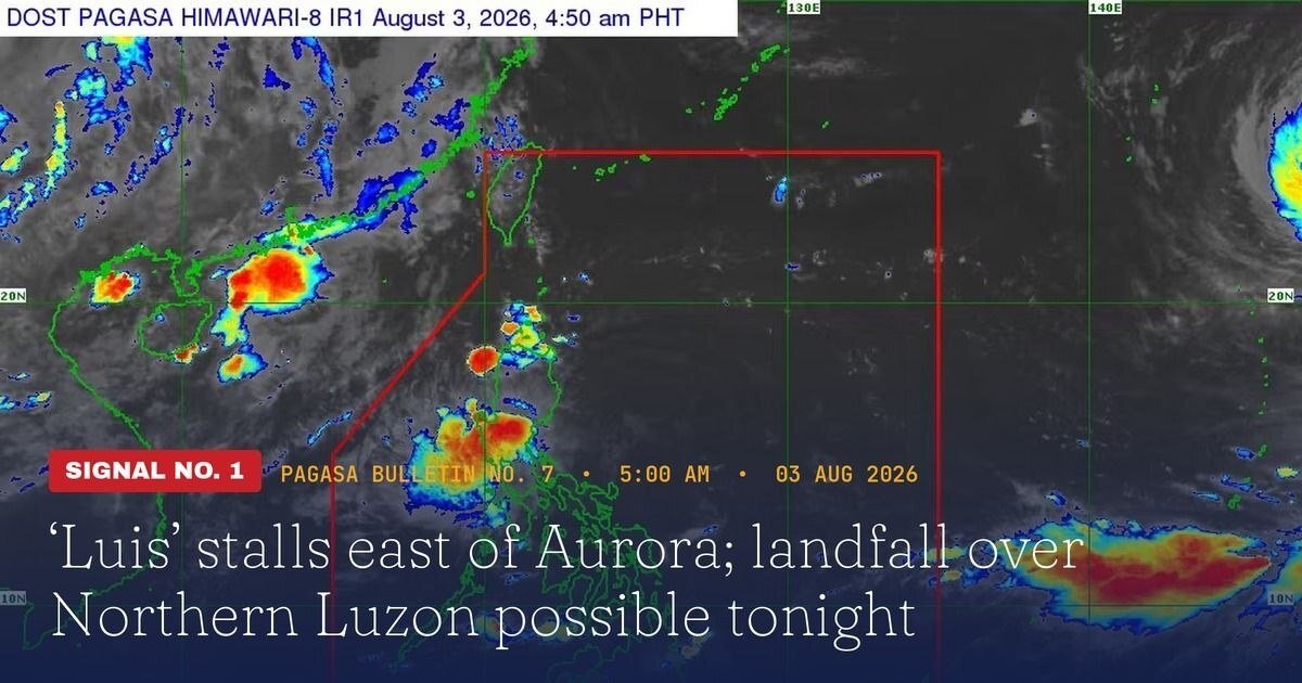
The Philippine Atmospheric, Geophysical and Astronomical Services Administration (PAGASA) issued a 5:00 a.m. bulletin placing Luis approximately 130 kilometers east-southeast of Casiguran, Aurora as of 4:00 a.m. that same morning. PAGASA reported that the storm was packing maximum sustained winds of 55 kilometers per hour close to its center, with gusts peaking at 70 km/h. Strong-wind coverage extended outward as far as 240 kilometers from the center, the agency added.
Areas Under Tropical Cyclone Wind Signal No. 1
Tropical Cyclone Wind Signal No. 1 — which alerts communities to expect strong winds within a 36-hour window — was in force over a broad stretch of Northern and Central Luzon, PAGASA confirmed. The following areas fell under the signal:
- Central and eastern Cagayan, including Tuguegarao City and Aparri
- Isabela province
- Quirino province
- Eastern and southern Apayao
- Eastern Kalinga, including Tabuk City
- Mountain Province and Ifugao
- Northern Aurora, including the towns of Baler and Casiguran
- Polillo Islands
- Northern Camarines Norte, including Daet
According to PAGASA, communities under Signal No. 1 can expect minimal to minor wind impacts, although isolated stronger gusts remain possible in exposed coastal zones and elevated terrain.
Southwest Monsoon Spreads Hazards to Visayas and Mindanao
PAGASA warned that the effects of Luis extend well beyond the formal signal areas. The Southwest Monsoon, energized by the storm’s outer circulation, is expected to generate strong to gale-force gusts across most of Luzon and the Visayas throughout Monday and Tuesday. In Mindanao, PAGASA identified Lanao del Norte, Misamis Occidental, Camiguin, Surigao del Norte, Dinagat Islands, Sarangani, Davao Occidental, and Davao Oriental as areas likely to experience enhanced gusts.
Looking ahead to Wednesday, August 5, the agency said gusty conditions would continue to affect most of Luzon and the Visayas, the Zamboanga Peninsula, Northern Mindanao, and sections of Caraga and the Davao Region. PAGASA directed the public to Weather Advisory No. 6 — likewise released at 5:00 a.m. Monday — for the detailed heavy-rainfall outlook linked to both Luis and the monsoon.
Mariners Cautioned as Seas Turn Rough Along Eastern Coasts
At sea, PAGASA flagged dangerous conditions along several coastlines. Waves of up to 2.5 meters are anticipated over the eastern seaboard of Isabela and Davao Oriental, as well as the northeastern seaboard of Aurora. Seas reaching up to 2.0 meters were forecast for the seaboards of Batanes, the Babuyan Islands, mainland Cagayan, Pangasinan, the Polillo Islands, Catanduanes, Northern Samar, and portions of Bicol, Caraga, and Davao.
The weather bureau advised operators of motorbancas and similar small watercraft to exercise extreme caution or refrain from putting out to sea altogether until conditions improve.
Storm Expected to Curve Away After Hitting Land
On its forecast path, PAGASA said Luis would continue on a general northwestward heading before striking Northern Luzon tonight or in the early morning hours of Tuesday. Following landfall, the storm is projected to execute a sharp east-northeastward turn and exit the Philippine landmass. The agency stressed, however, that the track forecast carries significant uncertainty and is subject to revision in subsequent bulletins.
PAGASA further noted that Luis is forecast to maintain tropical depression strength for most of the forecast period, potentially deteriorating into a remnant low by Wednesday. At that point, the system may be fully absorbed by Tropical Cyclone Dolphin — a super typhoon currently being tracked outside the Philippine Area of Responsibility (PAR). While Dolphin is considered unlikely to enter PAR, PAGASA said the super typhoon is expected to continue reinforcing the Southwest Monsoon, prolonging wet and windy conditions across the country.
Luis Is the Country’s 12th Cyclone This Year
PAGASA designated Luis as the Philippines’ 12th tropical cyclone of 2026 and the first storm of August. The agency projected that between two and four additional tropical cyclones could still develop within or move into PAR before the month ends, consistent with the typically active cyclone season during this period.
The weather bureau urged the general public, as well as local disaster risk reduction and management offices, to act swiftly in protecting lives and property. Residents in flood-prone, landslide-susceptible, and storm-surge-vulnerable areas were specifically directed to heed evacuation orders from their local governments. PAGASA scheduled its next bulletin for release at 8:00 a.m. Monday, August 3.
By the Numbers
- 130 km — Luis’s distance east-southeast of Casiguran, Aurora as of 4:00 a.m., August 3
- 55 km/h — maximum sustained winds near the storm’s center
- 70 km/h — maximum gustiness recorded near Luis’s center
- 240 km — outward reach of strong winds from Luis’s center
- 2.5 meters — highest forecast wave heights along the eastern seaboards of Isabela, Davao Oriental, and northeastern Aurora
- 12th — Luis’s designation as the 12th Philippine tropical cyclone of 2026
- 2 to 4 — number of additional cyclones PAGASA expects to form or enter PAR in August
Why This Matters
With landfall over Northern Luzon possible before Tuesday dawn, Tropical Depression Luis represents an immediate and serious threat to life and property across multiple provinces already under wind signals. The storm’s interaction with the Southwest Monsoon dramatically widens its footprint, bringing hazardous winds and heavy rainfall to communities from the Cordillera all the way to parts of Visayas and Mindanao — far beyond the areas directly in the storm’s path. PAGASA’s own acknowledgment of high track uncertainty makes it critical for residents and local governments in affected areas to monitor official bulletins closely and act on evacuation directives without delay.
Source: Originally reported by PAGASA and wire reports