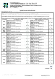
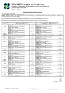
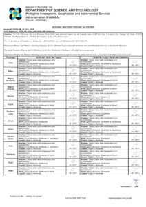
DUMAGUETE CITY, Negros Oriental — July 2, 2026 — The Philippine Atmospheric, Geophysical and Astronomical Services Administration (PAGASA) has placed Negros Oriental and the rest of the Visayas under a forecast of partly cloudy to at times cloudy skies, with scattered rainshowers and thunderstorms expected to develop at various points throughout Thursday. The agency released its regional bulletin at 5:00 AM today, covering Dumaguete City, Bayawan, Bais, Guihulngan, and the island province of Siquijor, among other areas.
Residents across the province should not expect a dry day. While some sunshine is possible, particularly during the morning, PAGASA’s forecast makes clear that rainfall and lightning activity are likely — the central question being when conditions deteriorate, not whether they will.
Temperature, Winds, and Sea Conditions
According to PAGASA’s 5:00 AM bulletin, lowland areas of Negros Oriental can expect temperatures ranging between a minimum of 26°C and a maximum of 32°C. Even on overcast mornings, the heat and humidity will remain noticeable, with temperatures potentially climbing before afternoon thundershowers bring temporary relief.
Winds are forecast to blow from the southwest to southeast direction at light to moderate speeds. Coastal waters around the province have been classified as slight to moderate — a rating that sits in the middle range of PAGASA’s wave scale, generally associated with wave heights of approximately 0.5 to 2.5 meters. While this does not represent dangerous open-sea conditions for larger vessels under normal circumstances, the presence of thunderstorms can cause rapid localized deterioration along any stretch of coastline.
By the Numbers
- Minimum temperature forecast: 26°C
- Maximum temperature forecast: 32°C
- Estimated wave height range under “slight to moderate” rating: 0.5 to 2.5 meters
- PAGASA bulletin release time: 5:00 AM, July 2, 2026
What Is Behind Today’s Weather Pattern
PAGASA’s regional forecast for the Visayas does not identify a specific weather system as the direct driver of Thursday’s conditions over Negros Oriental. However, the southwest-to-southeast wind direction is consistent with the prevailing summer monsoon pattern typical of the Philippine wet season at this time of year. Notably, PAGASA’s own website carries active advisories for both a Tropical Cyclone Warning for Shipping and a Tropical Cyclone Warning for Agriculture as of the bulletin’s issuance, signaling that an active tropical weather system is operating somewhere within the Philippine area of responsibility.
Despite these active shipping and agriculture advisories, Negros Oriental has not been placed under any tropical cyclone wind signal, and no named system has been directly linked to the local forecast. What this means practically is that the province is dealing with unsettled but not extreme weather — the kind of scattered afternoon thunderstorms familiar to anyone who has lived through a Philippine wet season.
Conditions Across the Province and Nearby Areas
From the coastal barangays of Dumaguete City to the upland communities of Guihulngan, and from the agricultural flatlands surrounding Bayawan to the slopes around Tayasan and Jimalalud, the weather picture across Negros Oriental is broadly uniform: alternating sunshine and clouds, with scattered rainshowers or thunderstorms arriving at some point during the day. PAGASA data places the temperature ceiling at 32°C, meaning mornings may feel deceptively manageable before conditions shift.
In Bais City, where dolphin-watching tours regularly depart onto Tañon Strait, the slight-to-moderate sea rating means excursions may proceed but should be monitored closely. Boat operators should be prepared to cut trips short if a squall develops. Siquijor, the island province located just southeast of Dumaguete, falls under the same Visayas regional forecast and can expect an identical weather profile — partly cloudy skies, the likelihood of rainshowers, and light to moderate winds.
Cebu, lying across Tañon Strait to the north and northwest, is covered by the same forecast parameters. This is directly relevant to passengers considering inter-island travel between Dumaguete Port and Cebu City on Thursday.
What “Slight to Moderate” Coastal Conditions Mean in Practice
PAGASA’s coastal water rating of “slight to moderate” does not mean conditions are uniformly safe for all types of watercraft. As noted in the agency’s bulletin context, larger inter-island ferries — such as those operated by 2GO, Lite Shipping, or fast-craft services like OceanJet on the Dumaguete–Cebu corridor — are generally able to operate under these conditions, though localized squalls tied to thunderstorm activity can still disrupt schedules and port visibility.
Small outrigger bancas, commonly used by local fisherfolk along the coasts of Negros Oriental and Siquijor, face significantly greater risk during thunderstorm passages over open water. Lightning, sudden wind gusts, and rapidly building swells make these conditions particularly hazardous for smaller vessels. Fisherfolk in areas such as Bacong, Dauin, Zamboanguita, and along the Siquijor shoreline are advised to return to shore well before any approaching storm cloud makes landfall — not after rain has already begun.
The Philippine Coast Guard and PAGASA’s Gale Warning and Tropical Cyclone Warning for Shipping pages, both active as of today’s bulletin, are recommended resources before any vessel departure.
Guidance by Sector
Commuters and Motorists
Those traveling along provincial roads — including the Dumaguete–Bayawan coastal highway or routes through the interior — should carry rain gear and anticipate slippery road surfaces once rain begins. Motorcycle riders in particular should gear up before departing. Drivers are advised to reduce speed when visibility drops during heavy downpours and to watch for flash flooding in low-lying barangays near rivers and drainage channels.
Fisherfolk and Coastal Communities
With thunderstorms possible at any point during the day and coastal waters rated slight to moderate, small-boat operators are urged to exercise caution. According to PAGASA’s advisory context, both the Gale Warning and Tropical Cyclone Warning for Shipping remain active, and all maritime travelers should verify conditions with the Philippine Coast Guard before departure. Do not rely solely on morning conditions as a guide — thunderstorms can develop rapidly over open water in the afternoon hours.
Farmers and Agricultural Workers
Scattered rainshowers generally benefit crops requiring moisture during the mid-year wet season, particularly in sugarcane and rice-growing areas. However, PAGASA’s forecast also carries the risk of gusty winds associated with thunderstorm cells, which can damage standing crops and young seedlings. Farmers are advised to secure equipment and avoid working in open fields during active lightning activity.
Students, Parents, and Schools
PAGASA’s forecast does not include conditions that would typically trigger class suspensions, and no such announcement is embedded in today’s bulletin. Nevertheless, parents are advised to send children to school equipped with umbrellas or rain jackets, as afternoon dismissal times may coincide with the most active window for rainshowers and thunderstorms. School administrators in flood-prone coastal barangays should monitor conditions from midday onward.
Inter-Island Ferry Passengers
Travelers planning to take ferries or fast-craft services from Dumaguete to Cebu, Tagbilaran (Bohol), or Siquijor should confirm schedules directly with their operators before proceeding to the port. While the “slight to moderate” coastal rating does not automatically trigger cancellations, operators may adjust departures if localized thunderstorms reduce port visibility or compromise safe boarding and unloading conditions.
Outdoor Workers and Event Organizers
Construction crews, market vendors, and outdoor event organizers across the province are advised to schedule the most demanding work during the earlier morning hours, when conditions are most likely to remain partly cloudy and relatively dry. Any outdoor afternoon activity — community events, sports competitions, outdoor markets — should have a contingency rain plan, with immediate shelter arrangements in place given the lightning risk associated with thunderstorm activity.
Why This Matters
A forecast combining scattered thunderstorms, temperatures of up to 32°C, and slight-to-moderate coastal waters simultaneously affects multiple sectors of life in Negros Oriental — from agricultural communities and fishing households to inter-island travelers and schoolchildren. The active Tropical Cyclone Warning for Shipping and Agriculture advisories noted by PAGASA indicate that the broader regional weather environment is unsettled, and conditions across the province could deteriorate rapidly during afternoon thunderstorm passages. Awareness of these forecasts is especially critical for fisherfolk operating small bancas and for ferry passengers, both of whom face amplified risk when thunderstorms develop over coastal and open waters with little advance warning.
Source: Breaking News Negros Oriental (breakingnewsnegrosoriental.com), citing PAGASA’s 5:00 AM regional forecast issued July 2, 2026.