DUMAGUETE CITY, Negros Oriental — The southwest monsoon is tightening its grip on Negros Oriental this Tuesday, August 11, 2026, bringing a full day of unsettled weather marked by rainshowers and thunderstorms, according to a regional forecast released by the Philippine Atmospheric, Geophysical and Astronomical Services Administration (PAGASA). Communities stretching from Dumaguete City in the south up to Guihulngan in the north — including coastal towns like Bais, Tanjay, La Libertad, and Bayawan — as well as the island of Siquijor across the strait, are all under the same wet weather picture.
The Force Behind Today’s Weather
PAGASA attributes Tuesday’s conditions to the habagat, the Filipino term for the southwest monsoon that dominates Philippine weather from approximately June through October each year. This wind system carries warm, moisture-saturated air off the sea and drives it inland, where it collides with terrain — including the mountain ridges behind Dumaguete and the hills surrounding Bayawan — forcing the air upward, where it cools and releases its moisture as rain.
Because the habagat operates as a broad, sustained wind pattern rather than a localized weather disturbance, it does not require a named tropical cyclone to produce widespread cloudiness, heavy showers, or afternoon thunderstorms. PAGASA noted that winds are blowing from the southwest at moderate speeds, a signature of classic monsoon-season weather affecting the entire Visayas.
Official Forecast for the Visayas, August 11, 2026
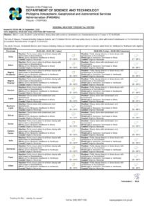
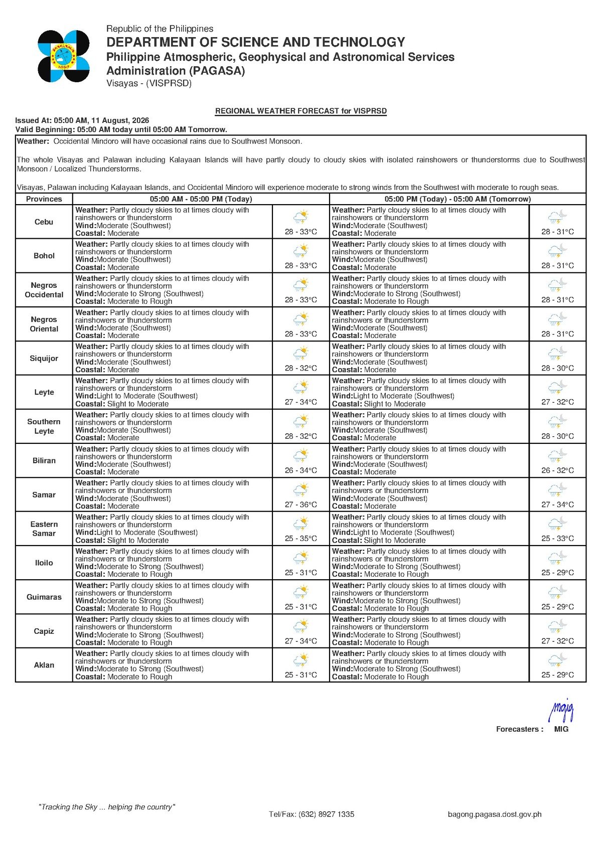
The PAGASA regional forecast for the Visayas, issued at 5:00 AM on Tuesday, August 11, 2026, outlines the following conditions:
- Sky condition: Partly cloudy to at times overcast
- Precipitation: Rainshowers or thunderstorms expected
- Temperature range: Low of 28°C, high of 33°C
- Wind direction: Southwest
- Wind speed: Moderate
- Coastal waters: Moderate sea conditions
Because the forecast covers the entire Visayas region, all areas of Negros Oriental — from provincial capital Dumaguete City in the south to Guihulngan in the north, plus the island of Siquijor — fall within this weather advisory. PAGASA stressed that showers and thunderstorms may occur at any hour of the day, with afternoon conditions typically intensifying due to heat-driven convection.
By the Numbers
- Forecast temperature low: 28°C (Tuesday, August 11)
- Forecast temperature high: 33°C (Tuesday, August 11)
- Extended outlook temperature low on Wednesday, August 12: 27°C
- Extended outlook temperature high on Wednesday, August 12: 33°C
- PAGASA morning forecast release time: 5:00 AM, August 11, 2026
- Extended outlook issued: 9:00 AM, August 10, 2026
Multi-Day Outlook: Conditions Likely to Worsen
The picture beyond Tuesday is worth close attention. PAGASA’s extended weather outlook, issued at 9:00 AM on Monday, August 10, 2026, shows that the unsettled pattern is expected to persist and possibly intensify over the next several days. The agency’s multi-day projection for the Visayas reads as follows:
- Monday, August 10: Temperatures 28°C–32°C; moderate to strong southwest winds; moderate to rough coastal conditions
- Tuesday, August 11: Temperatures 28°C–33°C; moderate to strong southwest winds; moderate to rough coastal conditions
- Wednesday, August 12: Temperatures 27°C–33°C; moderate to strong southwest winds; moderate to rough coastal conditions (partial data)
The critical detail in the extended outlook, according to PAGASA, is the projected strengthening of southwest winds — shifting from moderate to strong — and the accompanying deterioration of sea conditions from moderate to rough. Anyone with plans involving sea travel or open-water fishing operations should factor this trend into their decisions not just for Tuesday but for the remainder of the week.
Understanding Coastal Conditions: What the Ratings Mean
PAGASA classifies Tuesday’s sea state as moderate. In practical terms, moderate seas are generally navigable for larger commercial vessels such as roll-on/roll-off (RORO) ferries and fast crafts, though passengers may experience uncomfortable rolling. For small outrigger fishing boats — known locally as bangka — and other light watercraft, moderate conditions already carry meaningful risk.
The projected shift toward rough conditions in the coming days raises the stakes significantly. Rough seas can make crossings such as the Dumaguete-to-Siquijor route and inter-island passages to Cebu genuinely dangerous for smaller vessels. PAGASA strongly urges small-boat operators and fisherfolk to consult the agency’s latest marine bulletin before setting out, and to remain ashore if conditions appear unsafe.
Guidance Across Key Sectors
Motorists and Daily Commuters
Rain-slicked roads and reduced visibility during thunderstorm bursts will be the main hazards for motorists, particularly along the coastal highway from Dumaguete to Bayawan and on inland routes heading toward Guihulngan. Drivers are advised to slow down when rainfall is heavy, maintain safe following distances, and avoid crossing flooded road sections regardless of how shallow they may appear. Afternoon and evening hours tend to bring the heaviest convective showers during the monsoon season.
Fisherfolk and Marine Workers
Tuesday’s moderate coastal conditions are still manageable for larger vessels, but small outrigger craft should proceed with caution and stay close to shore. Given PAGASA’s warning that winds may strengthen and seas may turn rough by Wednesday, fisherfolk operating out of Dumaguete, Bais, Bayawan, and smaller coastal barangays are advised to coordinate with their local maritime or fisheries office and monitor the latest PAGASA marine forecast before each departure.
Ferry Passengers and Inter-Island Travelers
Passengers booked on services between Dumaguete and Siquijor, or on fast-craft and RORO routes to Cebu — operated by carriers such as OceanJet, Montenegro Lines, and others — should verify departure schedules directly with their vessel operators before proceeding to the port. While Tuesday’s conditions are rated moderate, PAGASA’s extended outlook signals rougher seas ahead. Port authorities retain the authority to suspend or cancel sailings based on actual conditions on the water.
Agricultural Workers and Farmers
Rain during the habagat season can bring beneficial soil moisture for rice, corn, and other crops grown across the province’s flatlands and foothills. However, thunderstorms carry lightning risk for workers in open fields, sugarcane plantations, and orchards. PAGASA advises that workers should seek solid shelter immediately upon hearing thunder — avoiding isolated trees and metal farm equipment — and should monitor low-lying farm plots for waterlogging during extended heavy rainfall.
Schools, Students, and Parents
Parents sending children to school on Tuesday should ensure youngsters carry raincoats or umbrellas, as showers can develop quickly and without advance warning. Should thunderstorms intensify significantly, school administrators are expected to follow existing Disaster Risk Reduction and Management (DRRM) protocols. Local government units typically announce class suspensions through official social media channels, and parents are encouraged to stay tuned to those platforms throughout the day.
Outdoor Workers and Event Organizers
Construction workers, market vendors, and those employed in open or semi-covered environments should anticipate rain interruptions at multiple points during the day. Organizers of outdoor gatherings — community events, sports competitions, or cultural celebrations — should have covered alternative venues or postponement plans ready. During the habagat season, skies can darken and wind can pick up sharply within minutes before a thunderstorm hits; when that happens, shelter should be sought immediately.
Key Reminder from PAGASA
PAGASA emphasizes that the habagat pattern driving Tuesday’s weather is broad in scope and is not dependent on any single storm system. This means that even in the absence of a named typhoon or tropical depression, the region can expect sustained wet conditions throughout the monsoon season. Residents, workers, and travelers across Negros Oriental and the wider Visayas should treat each PAGASA daily bulletin as an active advisory and adjust their plans accordingly.
The weather agency also reminds the public that its forecasts are updated throughout the day and that conditions can shift faster than predicted during the peak of the habagat season. The most reliable source for real-time updates remains the official PAGASA website and its authorized regional offices.
Why This Matters
The sustained southwest monsoon pattern forecast by PAGASA through at least Wednesday, August 12, poses compounding risks for communities across Negros Oriental — particularly for coastal residents, fisherfolk, and inter-island commuters as seas are projected to shift from moderate to rough. Farmers in open fields face lightning hazards during thunderstorm episodes, while motorists must contend with flooded roads and reduced visibility on key provincial routes. The multi-day nature of the unsettled outlook, rather than a single weather event, means that preparedness measures need to be maintained consistently across multiple sectors and not treated as a one-day concern.
Source: Breaking News Negros Oriental (breakingnewsnegrosoriental.com) / PAGASA regional forecast, August 11, 2026