Negros Oriental, August 12, 2026 — The southwest monsoon, locally called habagat, is keeping skies unsettled over Negros Oriental and the rest of the Visayas this Wednesday, with weather authorities warning residents to prepare for intermittent rain and possible afternoon thunderstorms throughout the day.
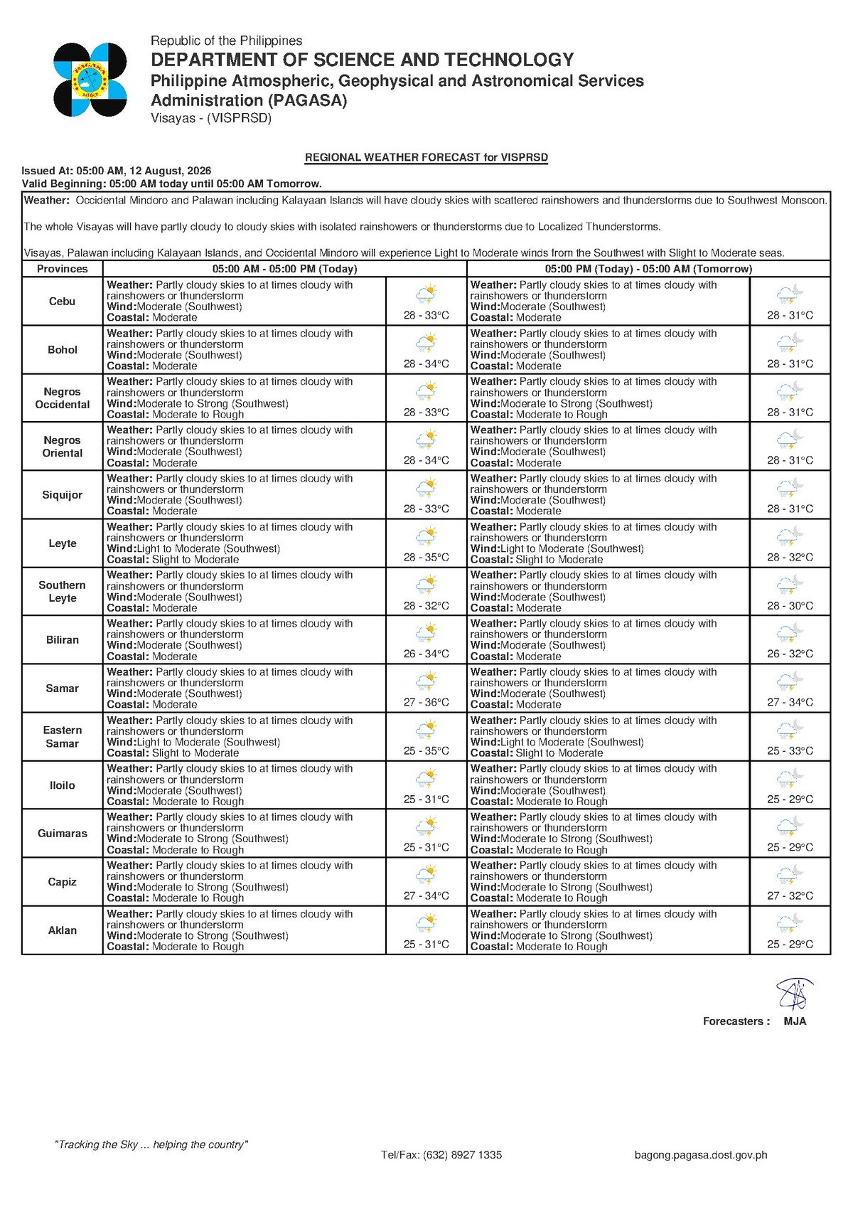
The Philippine Atmospheric, Geophysical and Astronomical Services Administration (PAGASA) released its regional forecast at 5:00 AM on August 12, 2026, covering the entire Visayas — including Negros Oriental cities and towns such as Dumaguete City, Bayawan, Bais, and Guihulngan, as well as the island province of Siquijor and the broader Cebu area.
What PAGASA Is Forecasting Today
According to PAGASA’s 5:00 AM bulletin, the Visayas can expect partly cloudy to at times cloudy skies throughout Wednesday, with rainshowers and the possibility of thunderstorms at various points during the day. The weather agency places the day’s temperature range between a low of 28°C and a high of 33°C — warm conditions tempered somewhat by cloud cover and rainfall.
Winds are blowing from the southwest at moderate speeds, consistent with ongoing habagat influence. Coastal sea conditions are likewise described as moderate, a classification that carries practical implications for fisherfolk, light watercraft operators, and ferry passengers.
PAGASA’s regional forecast for the Visayas reads: “Partly cloudy skies to at times cloudy with rainshowers or thunderstorm” — issued at 5:00 AM, August 12, 2026.
By the Numbers
- Forecast low temperature: 28°C (Wednesday); 27°C (Thursday)
- Forecast high temperature: 33°C (Wednesday and Thursday)
- Wind speed range classified as “moderate” by PAGASA: approximately 20 to 45 km/h
- Forecast coverage period: Wednesday, August 12 through Thursday, August 13, 2026
- 5:00 AM — time of issuance of Wednesday’s regional forecast
- 9:00 AM, August 11, 2026 — time of issuance of the extended weather outlook
The Habagat Explained
The habagat is a seasonal monsoon system that typically dominates Philippine weather from June through September, drawing warm, moisture-heavy air from the open ocean toward the archipelago. Rather than producing a single organized storm, PAGASA explains that the southwest monsoon generates a broad, persistent pattern of unsettled weather — one capable of spawning sudden and localized downpours, particularly during the afternoon and evening hours.
The practical result is that mornings may begin with only partial cloud cover, only for skies to darken rapidly and produce heavy thunderstorms by mid-afternoon. Residents across the Visayas are urged to treat each afternoon during habagat season as a potential rain event, even when mornings appear relatively clear.
Extended Outlook: Unsettled Weather Continues Through Thursday
Based on PAGASA’s extended weather outlook issued at 9:00 AM on August 11, 2026, the current pattern is not expected to ease by the following day. The weather agency projects that Wednesday’s conditions — partly cloudy to cloudy skies, moderate southwest winds, and moderate coastal sea states — will persist into Thursday, August 13.
Thursday’s temperature outlook is nearly identical to Wednesday’s, with the same high of 33°C but a slightly cooler low of 27°C. Coastal sea conditions will remain at the moderate level across both days. This means Negros Oriental residents should plan for at least two consecutive days of wet, variable weather before any improvement may be expected.
Guidance for Fisherfolk and Coastal Communities
PAGASA’s classification of coastal sea conditions as “moderate” is a direct concern for small vessel operators working out of ports along Negros Oriental’s coastline, including Dumaguete, Bais, Bayawan, and coastal barangays. Moderate southwest winds are capable of generating choppy, difficult-to-navigate waters for open bancas and small outrigger boats.
While PAGASA has not issued a formal gale warning as of this bulletin, the agency’s data underscores the need for caution. Fisherfolk are advised to evaluate conditions before departing, stay close to shore, and watch carefully for the rapid weather changes that thunderstorm conditions can bring. A sky that appears manageable in the morning can deteriorate quickly by early afternoon under habagat influence.
Ferry and Inter-Island Travel Advisories
Passengers traveling on inter-island routes — including the Dumaguete–Siquijor crossing and routes connecting Negros Oriental to Cebu — should anticipate some degree of pitching and rolling aboard ferries under moderate sea conditions. Larger vessels are generally capable of operating in these conditions, but PAGASA’s forecast does not rule out the possibility of rapidly worsening weather that could prompt delays or cancellations.
Travelers, including those booked with OceanJet and other Dumaguete-based ferry operators, are advised to confirm the status of their sailings before proceeding to the port. This is particularly important for early-morning and late-evening crossings, when visibility can be reduced and conditions may change quickly.
Advice for Farmers, Commuters, and Outdoor Workers
Agricultural workers across Negros Oriental face a mixed forecast. Moderate habagat rainfall can benefit crops in areas that have seen recent dry spells, but sudden thunderstorms bring flash flooding risks for low-lying fields and erosion hazards on sloped terrain. PAGASA’s forecast conditions are not suitable for field burning or clearing operations, as gusts accompanying thunderstorms can cause fire to spread rapidly and unpredictably. Farmers with recently harvested produce should secure their storage areas before the afternoon rain arrives.
For daily commuters, students, and parents in Dumaguete, Guihulngan, Bais, and other Negros Oriental communities, the highest risk period for thunderstorms typically falls between 2:00 PM and 6:00 PM under southwest monsoon conditions. Rain gear and early departure times are strongly recommended for afternoon travel. Low-lying streets and roads in the province can accumulate water quickly during heavy rain episodes, slowing traffic and creating hazards for both vehicles and pedestrians.
Outdoor workers — including those in construction, port operations, road repair, and market vending — should identify sheltered areas at their work sites where personnel can safely wait out heavy rain. Elevated or exposed work locations should be secured against wind gusts that often accompany afternoon thunderstorms.
What to Watch and Where to Follow
PAGASA updates its regional forecasts multiple times daily. Residents and workers across Negros Oriental are encouraged to check the official PAGASA website at pagasa.dost.gov.ph for the latest bulletins, especially before heading out for afternoon activities or travel. Given that habagat conditions can shift quickly, monitoring updated forecasts throughout the day is more reliable than relying on a single morning bulletin alone.
Why This Matters
The southwest monsoon’s sustained influence over the Visayas through at least Thursday means that residents, workers, and travelers across Negros Oriental face two consecutive days of elevated weather risk — from flash flooding and agricultural disruption inland to hazardous sea conditions along the coast. PAGASA’s classification of coastal waters as “moderate” directly affects the safety of thousands of fisherfolk and inter-island commuters who depend on daily sea crossings. Staying informed through official PAGASA forecasts and adjusting plans accordingly is the most effective way to reduce risk during this period of unsettled habagat weather.
Source: breakingnewsnegrosoriental.com / PAGASA regional forecast, August 12, 2026