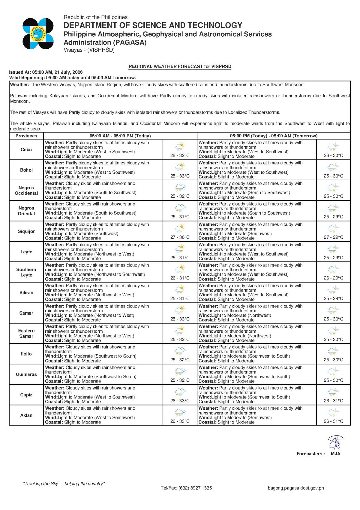
DUMAGUETE CITY, Negros Oriental — The southwest monsoon continues to assert its dominance over the Visayas this Tuesday, July 21, 2026, bringing with it a familiar mix of grey skies, intermittent downpours, and the threat of thunderstorms at virtually any hour of the day. The Philippine Atmospheric, Geophysical and Astronomical Services Administration (PAGASA) has issued a forecast covering the entire Visayas region, warning residents to remain prepared for wet and blustery conditions throughout the day.
PAGASA released its primary weather bulletin at 5:00 AM on July 21, covering Negros Oriental and the broader Visayas area. The agency also issued an extended outlook at 9:00 AM on July 20, 2026, confirming that the rainy pattern would persist from Monday into Tuesday — giving residents ample advance notice to prepare.
Southwest Monsoon at the Wheel
The dominant driver behind today’s weather, according to PAGASA’s extended outlook, is the southwest monsoon — known locally as habagat. Winds across the Visayas are blowing from the southwest to south direction, a hallmark of the monsoon season that typically runs from June through September across the Philippine archipelago.
The mechanics are straightforward: the habagat pushes large volumes of warm, moisture-saturated air from the southwest directly over the Visayas island group. As that humid air encounters elevated terrain and rises, it cools rapidly and releases its moisture as rain. The result is the kind of persistent, on-and-off rainfall punctuated by heavier thunderstorm bursts that communities across Negros Oriental have come to associate with the mid-rainy season. PAGASA notes that this pattern is entirely consistent with normal seasonal conditions for July.
Full Weather Breakdown for July 21
According to PAGASA’s bulletin issued at 5:00 AM, the following conditions are forecast for Negros Oriental and surrounding Visayas areas on Tuesday:
- Sky condition: Partly cloudy to at times cloudy
- Precipitation: Rainshowers or thunderstorms at any time of day
- Temperature (low): 26°C
- Temperature (high): 32°C
- Wind direction: West to southwest
- Wind speed: Light to moderate
- Coastal water state: Slight to moderate
This forecast applies across the full breadth of the Visayas region. Communities in Negros Oriental — including Dumaguete City, Bayawan City, Bais City, Guihulngan City, and Canlaon City — fall under these conditions, as do Siquijor Island and the neighboring province of Cebu, along with areas in Eastern Visayas.
By the Numbers
- Overnight low temperature: 26°C
- Daytime high temperature: 32°C
- Extended outlook high temperature: 33°C
- “Slight” wave height range: approximately 0.5 to 1.25 meters
- “Moderate” wave height ceiling: approximately 2.5 meters
- Primary bulletin release time: 5:00 AM, July 21
- Extended outlook release time: 9:00 AM, July 20, 2026
Understanding “Slight to Moderate” Seas
PAGASA classifies today’s coastal waters around Negros Oriental, Siquijor, and the Cebu Strait as “slight to moderate.” This terminology carries practical significance for anyone whose livelihood or travel plans involve the sea. According to PAGASA’s sea state classifications, “slight” conditions generally correspond to wave heights of roughly 0.5 to 1.25 meters, while the upper end of “moderate” can see waves reaching approximately 2.5 meters.
The “slight to moderate” designation means conditions can shift within this range depending on location, time of day, and whether a passing thunderstorm temporarily amplifies wind speed and chop. While larger vessels are generally not at significant risk under these conditions, small open-hulled fishing boats and outrigger bancas require careful judgment and close attention to changing skies.
Guidance for Specific Sectors
Fisherfolk and Small-Boat Operators
PAGASA advises small-boat operators and fisherfolk to monitor sea and sky conditions closely before departing. Thunderstorms can develop rapidly and intensify winds and waves with minimal warning. Anyone already at sea when a storm cell approaches should head immediately for the nearest safe shoreline. The combination of slight-to-moderate base conditions and the added risk of thunderstorm-driven gusts makes caution especially important for bancas and other low-sided vessels operating near Negros Oriental, Siquijor, and the Cebu Strait.
Ferry and Inter-Island Passengers
Travelers on inter-island routes — including the Dumaguete–Cebu and Dumaguete–Siquijor crossings served by carriers such as OceanJet, Montenegro Lines, and other ferry operators — should confirm their departure status directly with their operator before proceeding to the port. PAGASA notes that while baseline coastal conditions are manageable for larger vessels, sudden thunderstorm activity can prompt schedule adjustments. Passengers should check for updates on the day of travel.
Farmers and Agricultural Workers
Agricultural communities across Negros Oriental — particularly those cultivating sugarcane, rice, and vegetables in the lowlands around Bais and Bayawan and in the upland areas near Guihulngan and Canlaon — should inspect field drainage ahead of today’s expected rains. Repeated daily showers during the rainy season can saturate soil rapidly, placing low-lying fields at risk of waterlogging. PAGASA’s forecast of intermittent rainfall also advises against pesticide or fertilizer application today, as precipitation can wash chemical inputs away before absorption, resulting in both wasted resources and potential contamination of nearby water sources.
Students, Parents, and School Administrators
Because PAGASA warns that rainshowers and thunderstorms may occur at any point during the day — not solely during the typical late-afternoon window — parents should ensure children carry rain protection to school on Tuesday. Downpours are equally likely during morning arrival, midday recess, and afternoon dismissal. School administrators in Dumaguete and across the region are encouraged to have contingency arrangements in place should a heavy, sustained rain event develop during school hours.
Motorcycle Riders and Outdoor Workers
Motorcycle riders, who represent one of the most common forms of transportation across Negros Oriental, should keep rain gear accessible throughout the day. Wet road surfaces — particularly on curves along the coastal highway toward Bayawan and on the mountain interior routes approaching Guihulngan — significantly reduce tyre grip. PAGASA recommends reduced speeds, greater following distances, and the use of headlights during heavy downpours to improve visibility. Outdoor laborers, including construction workers, should suspend work and seek solid shelter immediately upon hearing thunder or observing lightning.
What to Expect in the Days Ahead
PAGASA’s extended weather outlook, released at 9:00 AM on July 20, 2026, projects that the southwest monsoon pattern will sustain itself through Monday and Tuesday, keeping conditions largely unchanged. The extended forecast shows temperatures ranging between 26°C and 33°C over that period, with light-to-moderate southwest-to-south winds and slight-to-moderate coastal states — virtually mirroring the Tuesday primary bulletin.
The agency notes that individual days may differ in rainfall intensity, but the overarching wet, monsoon-driven pattern is expected to persist as July continues. Residents of Negros Oriental and the wider Visayas should accordingly plan their week around the likelihood of daily rain, rather than expecting a significant dry spell in the near term.
Why This Matters
The PAGASA forecast covering July 21, 2026 directly affects the daily safety and livelihood decisions of hundreds of thousands of residents across Negros Oriental, Siquijor, Cebu, and Eastern Visayas — from fisherfolk assessing whether to put their bancas to sea, to farmers protecting standing crops, to commuters navigating rain-slicked roads. The confirmation that the southwest monsoon will continue to drive wet conditions through the extended outlook period means that communities cannot expect relief in the immediate days ahead. Understanding the practical meaning of PAGASA’s sea state and precipitation forecasts empowers residents to make informed, safety-conscious decisions during what the agency identifies as a typical but consequential mid-rainy-season pattern.
Source: Breaking News Negros Oriental (breakingnewsnegrosoriental.com)