DUMAGUETE CITY, Negros Oriental — September 3, 2026 — The southwest monsoon is keeping skies unsettled over Negros Oriental this Thursday, with the Philippine Atmospheric, Geophysical and Astronomical Services Administration (PAGASA) forecasting intermittent rainshowers, possible thunderstorms, and moderate sea conditions that will affect commuters, fisherfolk, farmers, and coastal communities throughout the day.
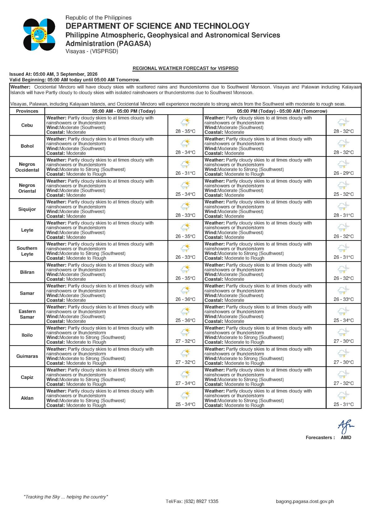
PAGASA released its Visayas Regional Forecast at 5:00 AM on September 3, 2026, while a separate extended weather outlook was issued at 9:00 AM on September 2, 2026 — both painting a consistent picture of persistent monsoon weather that is expected to carry into Friday as well.
The Southwest Monsoon at Work
The weather pattern driving today’s conditions is the habagat, or southwest monsoon — the seasonal wind system that dominates Philippine weather from roughly June through September each year, according to PAGASA. During this period, warm and moisture-heavy air is drawn northeastward from the southwest, blanketing the archipelago in humid, rain-prone conditions.
PAGASA’s extended outlook confirms that southwest winds at moderate speeds are the dominant feature of the regional weather pattern for both Thursday and Friday. When the moisture-laden monsoon air encounters the coastal ranges and mountain interiors of the Visayas — including Negros Oriental’s interior highlands — it rises, cools rapidly, and releases rainfall. This mechanism produces the characteristic pattern of repeated, on-and-off showers and occasional thunderstorms rather than a single sustained downpour across the entire day.
Residents should expect rain to arrive in bursts, sometimes accompanied by lightning, with partial clearing in between. The broad pattern, PAGASA’s data indicates, will not shift significantly within the next 48 hours.
Forecast Details for Negros Oriental and the Visayas
For the province of Negros Oriental, PAGASA’s 5:00 AM forecast on September 3 describes partly cloudy to at times cloudy skies with rainshowers or thunderstorms expected during the day. The agency’s figures for current conditions and the extended outlook are as follows:
- Temperature (Thursday, September 3): Low of 28°C, high of 35°C — warm, humid conditions that heighten discomfort during any dry spells in the midday heat.
- Temperature (Friday, September 4): A slight easing to a low of 27°C and a high of 34°C.
- Wind: Moderate speed, blowing consistently from the southwest on both days.
- Coastal Waters: Moderate sea conditions around Negros Oriental on both Thursday and Friday, indicating elevated wave activity above calm baseline levels.
PAGASA noted that neighboring areas — including Siquijor, the southern coast of Cebu, and other central Visayas provinces — are under the same general regional forecast, with equivalent wind, temperature, and sea condition parameters applying across the area.
The agency’s extended outlook makes clear that no dramatic improvement is expected over the next two days. Moderate monsoon conditions will persist, and residents should plan accordingly rather than waiting for conditions to clear.
By the Numbers
- 5:00 AM — time PAGASA released the September 3 Visayas Regional Forecast
- 9:00 AM, September 2 — time PAGASA issued the extended weather outlook
- 28°C — forecast low temperature for Negros Oriental on Thursday
- 35°C — forecast high temperature for Negros Oriental on Thursday
- 27°C / 34°C — forecast low and high temperatures for Friday, September 4
What the Forecast Terms Actually Mean
Moderate Winds
In PAGASA’s marine and regional forecasting language, “moderate” wind does not mean gentle. The agency uses this classification to describe winds that are sustained and noticeably strong — capable of raising spray on open water, pushing small vessels off course, and dislodging unsecured objects on land. Outdoor signage, tarpaulins, and lightweight structures should be secured. While this wind speed falls well short of gale force, it is far from a light breeze.
Moderate Coastal Conditions
When PAGASA rates coastal sea conditions as “moderate,” it signals that waves and swells are elevated to a level that poses real discomfort and potential hazard for small, low-powered watercraft. According to PAGASA’s classification system, this means fishing bancas, pump boats, and small motorboats must exercise caution and carefully assess conditions before heading out. Larger inter-island ferries can generally operate under moderate conditions, but the agency notes that schedule adjustments remain possible based on operator safety assessments.
Rainshowers or Thunderstorms
This phrasing in PAGASA forecasts signals that rainfall is anticipated but will not necessarily be continuous or province-wide at any given moment. Showers may be brief and scattered. However, the possibility of thunderstorm development is real — and during the southwest monsoon season, thunderstorms can form quickly and deliver locally intense downpours within minutes. Such concentrated rainfall is enough to trigger localized flooding in low-lying barangays or flash flooding near river channels and drainage areas.
Practical Guidance for Residents
Ferry Passengers and Land Commuters
Anyone planning to travel by sea — whether on the Dumaguete-Siquijor route or on inter-island services to Cebu and other Visayas ports — should contact their ferry operator before heading to the port, PAGASA advisories suggest. Moderate coastal conditions can cause schedule delays or cancellations. Inter-island services including OceanJet and other operators will make independent assessments of passenger safety. Land commuters in Dumaguete City and other municipalities should watch for localized road flooding near rivers and low-lying zones, particularly during and immediately after heavy showers.
Fisherfolk and Small-Boat Operators
The combination of moderate southwest winds, moderate coastal conditions, and the risk of sudden thunderstorm development makes today a high-caution day for small fishing vessels. PAGASA’s forecast language specifically warrants that operators of fishing bancas and pump boats — particularly those working open-water fishing grounds off Bayawan, Bais, and Guihulngan — assess sea conditions carefully before departure. If a thunderstorm develops while vessels are at sea, immediate shelter should be sought. Open-water exposure during a thunderstorm on a small vessel carries serious risk.
Farmers and Agricultural Workers
Cloud cover and intermittent rainfall will moderate daytime heat, reducing stress on field crops and cutting irrigation needs. However, PAGASA’s forecast of possible thunderstorms raises the risk of heavier-than-expected rainfall, which can cause waterlogging in rice paddies and vegetable plots in the interior municipalities of Negros Oriental. Clearing drainage channels ahead of incoming showers is advisable. For those planning to harvest mature crops, the agency’s forecasting pattern suggests that early morning or late afternoon — when monsoon showers tend to ease briefly — offers the best windows for harvest activity.
Students, Parents, and School Communities
PAGASA has not issued a severe weather warning that would automatically trigger school suspension protocols. However, parents in flood-prone communities — especially in low-lying barangays of Dumaguete City, Bais, and coastal municipalities — should monitor local government announcements throughout the morning. Children should be sent with rain gear, and households in flood-prone areas should remain alert to rapidly changing conditions if thunderstorms develop during school hours.
Why This Matters
The sustained southwest monsoon pattern forecast by PAGASA for both September 3 and 4 means that Negros Oriental residents, fisherfolk, and agricultural workers face a prolonged period of weather-related disruption — not a single brief storm event. Moderate coastal conditions sustained over multiple days increase cumulative risk for small vessel operators who may feel pressure to head out despite the warnings. At the same time, repeated thunderstorm-driven downpours over interior municipalities raise the risk of localized flooding and crop damage that could affect food production and livelihoods across the province.
Source: PAGASA Visayas Regional Forecast, September 3, 2026 (5:00 AM) and Extended Outlook, September 2, 2026 (9:00 AM), as originally reported by breakingnewsnegrosoriental.com