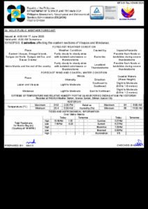
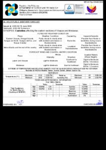
DUMAGUETE CITY — Cloudy skies, intermittent downpours, and the threat of thunderstorms are in store for Negros Oriental on Thursday, June 19, 2026, following a regional weather forecast released by the Philippine Atmospheric, Geophysical and Astronomical Services Administration (PAGASA) at 5:00 AM. The state weather bureau’s advisory covers the entire Visayas region, placing both the island province and neighboring Siquijor under similar conditions for most of the day.
The forecast was not issued in response to any typhoon or major weather disturbance. Rather, PAGASA described current atmospheric conditions as producing “partly cloudy skies to at times cloudy with rainshowers or thunderstorm” — a weather pattern that may begin with relatively calm morning skies before transitioning into heavier afternoon showers and electrical activity.
Coverage Across Negros Oriental
The weather advisory from PAGASA applies across the full length and breadth of Negros Oriental. This includes the provincial capital, Dumaguete City, situated in the southern portion of the province, as well as the cities of Bais and Bayawan further along the western coastline. Northern municipalities such as Guihulngan and Canlaon — both known for their agricultural activity — are equally covered under the forecast, as is the island of Siquijor, which sits just south of Negros Oriental and is reachable by ferry from Dumaguete.
PAGASA noted that temperatures across the affected area will range between a low of 25°C and a high of 33°C throughout Thursday, consistent with the humid, warm character of the Visayas during the June wet season. Winds are expected to blow from the southeast to east direction at light to moderate speeds — not strong enough for a gale advisory, but enough to create noticeable surface chop along open coastlines.
Sea Conditions and Ferry Travel
According to PAGASA, coastal waters in the area will be classified as “slight to moderate,” a rating that indicates manageable wave heights for larger vessels but potentially challenging conditions for smaller watercraft including outrigger bancas and non-motorized fishing boats. Residents in barangays facing the Tañon Strait and the Bohol Sea are advised to stay alert to changing sea conditions throughout the day.
Passengers with scheduled ferry trips between Dumaguete and Cebu, or those taking inter-island routes to Siquijor via the ports of Sibulan or Bontod, should be aware that operators such as OceanJet typically continue services under slight to moderate sea states. However, the Philippine Coast Guard has standing protocols for adjusting or suspending sailings when on-site conditions deteriorate beyond forecast levels. Travelers are strongly encouraged to check directly with their ferry operator and to monitor official Philippine Coast Guard advisories before heading to the port, particularly for early morning departures when weather patterns are still developing.
Fisherfolk and Farmers Urged to Exercise Caution
Fishing communities in coastal towns including Manjuyod, Bindoy, Amlan, and the Bais Bay shoreline area should take note of Thursday’s sea conditions before heading out. PAGASA’s regional forecast classifies coastal waters as slight to moderate, and while this may appear manageable, local sea conditions can deviate significantly from the broader regional picture depending on wind behavior and proximity to open water. Small-scale fisherfolk relying on bangkas and non-motorized vessels are advised to personally assess conditions at their point of departure before setting sail.
For farmers, the threat of rain and thunderstorms carries practical consequences. Sugarcane and rice producers in the lowland areas near Bayawan, as well as those tending upland vegetable plots near Valencia and Canlaon, may need to delay field activities given the risk of sudden heavy downpours. PAGASA warned that intense rain accompanying thunderstorms can trigger brief, localized flooding in low-lying agricultural areas and may damage crops or harvested produce left exposed in the open.
Three-Day Weather Outlook Through the Weekend
PAGASA’s extended forecast, which was issued at 9:00 AM on Tuesday, June 17, 2026, provides residents with a forward-looking summary of conditions expected from Wednesday through Friday. According to the agency’s extended outlook:
- Wednesday, June 18: Temperatures between 26°C and 32°C. Winds: Light to Moderate, Southeast to East. Coastal Condition: Slight to Moderate.
- Thursday, June 19: Temperatures between 25°C and 33°C. Winds: Light to Moderate, Southeast to East. Coastal Condition: Slight to Moderate.
- Friday, June 20: Temperatures between 26°C and 33°C. Winds: Light to Moderate, Southeast to East. Coastal Condition: Slight to Moderate.
The relative consistency of these figures across all three days, as noted in the PAGASA bulletin, suggests that no abrupt weather shift is expected before the week closes out. The prevailing southeasterly to easterly wind pattern is associated with the onset and deepening of the habagat, or southwest monsoon season, which PAGASA has identified as the primary driver of afternoon and evening rain activity across the Visayas from June onward.
Mountain Roads and Flash Flood Risks
Motorists using mountain passes and highland routes across Negros Oriental — including the Dumaguete-Valencia highway and roads traversing the elevated areas of Guihulngan and Bindoy — should anticipate reduced visibility and slippery road surfaces during periods of heavy rainfall. PAGASA’s forecast of intermittent thunderstorms means that road conditions can deteriorate rapidly and without much warning.
Residents in upland and hillside communities in municipalities such as Valencia, Mabinay, and Siaton should monitor for runoff activity in gullies, drainage channels, and stream banks, particularly during prolonged or intense rain episodes. Low-lying areas and communities near creeks are advised not to venture near waterways during active thunderstorm activity.
Safety Precautions During Thunderstorms
Even in the absence of a typhoon signal, PAGASA’s advisory serves as a practical reminder that everyday thunderstorms carry real hazards. Members of the public spending time outdoors — including market vendors, construction workers, students, and commuters — should carry rain protection and remain alert to sudden changes in sky conditions throughout the afternoon.
During active lightning and thunderstorm periods, PAGASA advises the public to avoid sheltering under tall trees, open metal structures, or elevated ground. Parents and guardians arranging school pick-ups should factor in the possibility of afternoon storms when planning travel times.
Stay Updated Through Official Channels
Weather in the Philippines, and the Visayas in particular, can shift significantly within short timeframes. PAGASA strongly encourages the public to treat regional forecasts as a general guide and to observe actual local conditions as the day progresses. Residents should listen to local radio broadcasts and monitor updates on the PAGASA official website at pagasa.dost.gov.ph for any revisions to the advisory as conditions develop.
The Philippine Coast Guard likewise issues real-time advisories on sea conditions and port closures, which ferry passengers and fisherfolk are encouraged to follow alongside PAGASA updates.
Source: Breaking News Negros Oriental (breakingnewsnegrosoriental.com)