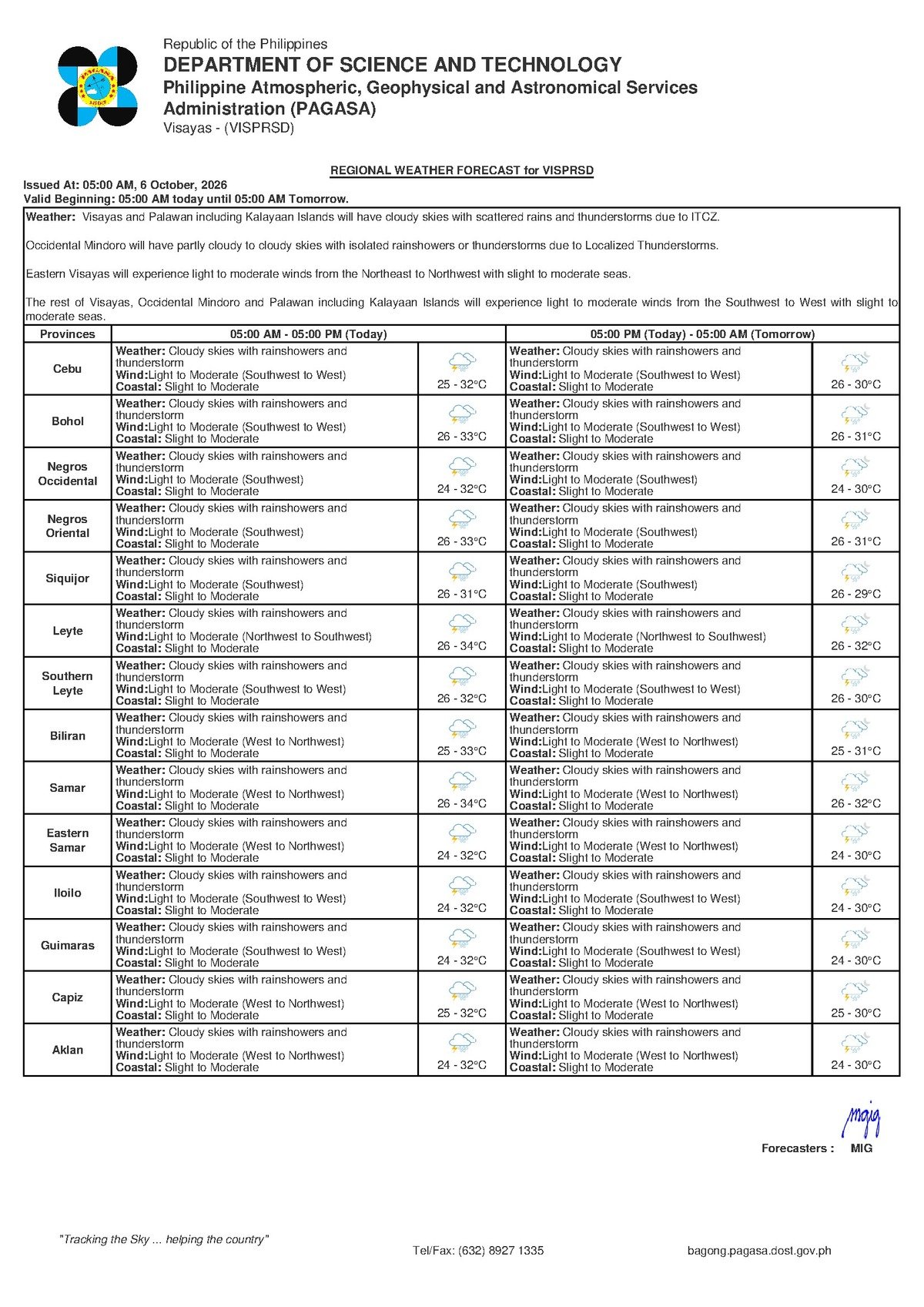
As Tuesday, October 6, 2026, dawns, communities throughout Negros Oriental and the wider Visayas region are advised to brace for prevalent cloudy conditions accompanied by scattered rainshowers and thunderstorms. The Philippine Atmospheric, Geophysical and Astronomical Services Administration (PAGASA) released its updated regional forecast early this morning, at 5:00 AM, urging the public to stay vigilant.
PAGASA projects temperatures in Negros Oriental to fluctuate between a low of 25 degrees Celsius and a high of 32 degrees Celsius today. This combination of warm air and ample moisture creates favorable conditions for convective rainfall to develop across the province, impacting areas from Dumaguete City in the south to Guihulngan in the north, and including southern localities like Bayawan City.
Winds are expected to be light to moderate, primarily originating from the Southwest to West. This prevailing wind direction will contribute to slight to moderate coastal conditions throughout the Visayas. While generally suitable for maritime activities, the presence of thunderstorms always carries the potential for sudden, localized gusts and rougher waters.
Understanding Today’s Weather Drivers
The regional forecast for the Visayas from PAGASA does not identify a specific major weather system, such as a low-pressure area or a monsoon, as the primary influence for today’s conditions. Nevertheless, the light to moderate winds blowing from the Southwest to West are characteristic patterns that frequently transport moisture-laden air, fostering cloud formation and the subsequent development of rainshowers and thunderstorms across the entire region.
This atmospheric setup suggests that localized moisture, potentially amplified by daytime heating, will lead to scattered but possibly intense rainfall. Residents are encouraged to closely monitor local conditions, as these isolated thunderstorms can materialize quickly and deliver varying intensities of rain across different areas.
Specific Conditions for Negros Oriental and Visayas
The entire Visayas region, encompassing neighboring provinces such as Siquijor and Cebu, is expected to encounter similar weather. For Negros Oriental, this translates to coastal communities like Dumaguete City, Bais City, and Bayawan City likely experiencing cloudy skies with intermittent rainshowers. Inland areas and towns situated near mountain ranges, including Guihulngan City and localities along the central mountainous spine of the province, may encounter more frequent or heavier thunderstorms due to orographic lifting, a phenomenon where moist air is forced upward by terrain.
Looking ahead, PAGASA’s extended weather outlook, issued at 9:00 AM on October 5, 2026, offers insight into the coming days. For Tuesday, October 6 (today), temperatures are anticipated to be slightly higher, ranging from 27°C to 33°C, with light to moderate winds from the Southwest, maintaining slight to moderate coastal conditions. This weather trend is expected to persist into Wednesday, October 7, with comparable temperature ranges and light winds.
The consistent forecast for rainshowers and thunderstorms over these days highlights the ongoing need for readiness, particularly for individuals with outdoor plans or those residing in areas susceptible to flooding.
No Active Weather Warnings Issued
As of PAGASA’s latest bulletin for the Visayas, no active severe weather warnings are in effect. This means that no Yellow, Orange, or Red Rainfall Warnings, Tropical Cyclone Wind Signals, Gale Warnings, or specific Heat Index advisories have been issued for the region. While this indicates no widespread severe weather threat, the public should remember that “rainshowers and thunderstorms” can still bring significant localized rainfall and lightning, necessitating caution.
The absence of these warnings does not imply a complete lack of risk; rather, it suggests that the forecasted conditions fall within expected parameters for this period of the year without escalating to official warning levels. Residents are always advised to use personal judgment and implement necessary precautions, especially when thunderstorms are present.
By the Numbers
- Forecast date: October 6, 2026
- Initial forecast release time: 5:00 AM
- Negros Oriental temperature range (Oct 6): 25°C to 32°C
- Extended outlook release date: October 5, 2026
- Extended outlook release time: 9:00 AM
- Projected temperature range (Oct 6): 27°C to 33°C
- Expected similar conditions for Wednesday, October 7
Why This Matters
The forecast of cloudy skies with rainshowers and thunderstorms holds several implications for daily life in Negros Oriental. Commuters and travelers in Dumaguete City and other urban centers should prepare for potentially slippery roads and reduced visibility during downpours, allowing extra travel time. Fisherfolk and small boat operators, despite generally favorable coastal conditions, must monitor local weather closely and be aware of sudden changes due to thunderstorms. Farmers can benefit from the rain but should also assess drainage systems to protect crops from potential waterlogging. Students and parents should prepare for wet weather commutes, while outdoor workers and event organizers should have contingency plans for rain to ensure safety and comfort.
In essence, while no severe weather warnings are currently active for October 6, 2026, a degree of preparedness and vigilance is prudent for all residents of Negros Oriental. Taking simple precautions can help ensure safety and minimize disruptions to daily routines.
Source: wire reports