DUMAGUETE CITY, Negros Oriental — The Philippine Atmospheric, Geophysical and Astronomical Services Administration (PAGASA) has placed the Visayas region, including Negros Oriental, under a forecast of cloudy skies, rainshowers, and thunderstorms for Monday, October 5, 2026. Coastal waters are also elevated, raising caution flags for ferry passengers, fishers, and small-boat operators across the province.
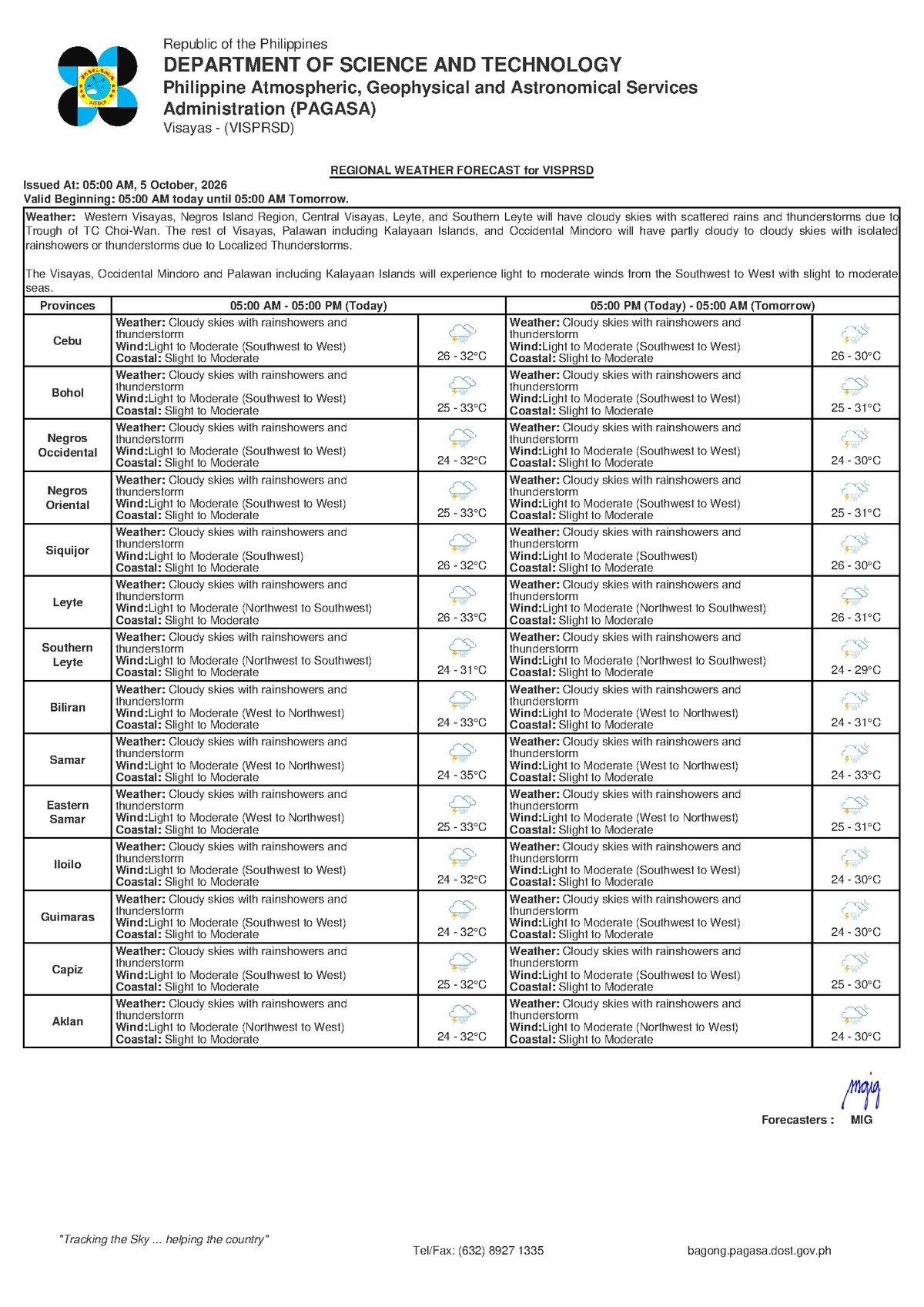
The bulletin was released by PAGASA at 5:00 AM on October 5, 2026, covering the whole Visayas region.
Today’s Forecast at a Glance
According to PAGASA, Monday will bring cloudy skies with rainshowers and thunderstorms across the Visayas, Negros Oriental included. Daytime temperatures will hover between 26°C and 32°C, kept in check by persistent cloud cover and rainfall. Prevailing winds are blowing from the southwest to west at light to moderate speeds.
PAGASA classifies coastal water conditions as slight to moderate — wave heights that larger commercial vessels can generally handle, but that pose real risk for small bancas and outrigger boats. Affected sea lanes include the passage between Dumaguete and Siquijor, the Tanon Strait separating Negros and Cebu, and waters off Bayawan and Bais.
Behind the Weather Pattern
PAGASA’s regional forecast data for this bulletin does not name a specific weather system. However, the state weather bureau notes southwest to westerly winds — a pattern associated with the southwest monsoon, or habagat, which drives moist air across the archipelago and fuels cloud build-up, rain, and thunderstorms in the Visayas. October is a transitional month in the Philippines, when the habagat gradually gives way to the northeast monsoon (amihan), though rain-producing conditions can remain active during this changeover period, PAGASA has noted in past seasonal outlooks.
Note: This article will be updated when PAGASA releases a more detailed advisory identifying the specific driving weather system.
Breaking Down the Forecast Terms
Rainshowers and Thunderstorms
“Rainshowers” refer to intermittent, on-and-off bursts of rain rather than unrelenting downpours. The addition of “thunderstorms,” however, signals more serious conditions: intense rain cells with lightning, strong wind gusts, and the potential for sudden localised flooding. PAGASA’s advisory is a reminder that low-lying areas in Dumaguete, Bayawan, and floodplains near Bais and Guihulngan are particularly susceptible to rapid water accumulation when storm cells move through.
Light to Moderate Winds
On land, light to moderate winds translate to breezy but generally non-destructive conditions. At sea, however, PAGASA’s classification means that even moderate wind speeds can generate uncomfortable swells — especially across open-water passages — putting small fishing boats and bancas at heightened risk.
Slight to Moderate Coastal Waters
PAGASA uses a scale ranging from “slight” (calm, small waves) to “rough” (large, hazardous waves). A “slight to moderate” rating means wave heights are elevated above normal but still within a range navigable for larger ferries. Passengers on inter-island routes should nonetheless prepare for rougher-than-usual crossings and possible schedule disruptions.
What This Means for Negros Oriental
Ferry and Inter-Island Travel
Travellers departing from Dumaguete Port — on routes served by OceanJet, Lite Shipping, and other operators heading to Siquijor, Cebu, and Bohol — are advised to check with their carriers before leaving home. According to PAGASA’s coastal water classification, slight to moderate sea conditions can trigger delays, rerouting, or outright cancellations, particularly for fast-craft vessels, which are more wave-sensitive than conventional roll-on, roll-off (RoRo) ferries. The busy Siquijor-Dumaguete short-hop crossing may experience choppy conditions throughout the day.
Fisherfolk and Small-Boat Operators
PAGASA’s slight-to-moderate coastal rating is a direct caution for small banca operators and fisherfolk. Those intending to work the Tanon Strait, the waters off the Siquijor coast, or coastal barangays near Bayawan and Mabinay should closely monitor sea conditions before heading out. Should thunderstorms develop, PAGASA’s standing guidance is to return to shore immediately — lightning at sea is life-threatening, and gusts from storm cells can intensify with minimal warning.
Farmers in the Province
Sugarcane and rice farmers in the flatlands of Bais, La Libertad, and Guihulngan should expect weather interruptions to fieldwork throughout the day, given the forecast of intermittent rainshowers and thunderstorms. Proper drainage and temporary cover for harvested crops or newly planted seedlings are advisable. While upland barangays in drier areas may benefit from the rainfall, sudden heavy downpours risk waterlogging low-elevation fields.
Students, Parents, and Daily Commuters
Monday is a regular school and work day, and parents in Dumaguete, Bayawan, Bais, and other towns across Negros Oriental should send children out with rain gear. PAGASA’s forecast notes that thunderstorm cells can develop quickly even after stretches of overcast but relatively dry skies. Early commuters may find morning conditions manageable, but afternoon school dismissal could overlap with heavier rainfall episodes. Schools and local government units are encouraged to track PAGASA updates through the morning hours.
Outdoor Workers and Event Organisers
Construction crews, utility workers, and others with outdoor schedules on Monday should factor in weather-related stoppages. Thunderstorms, per PAGASA’s definition, carry lightning risk that can necessitate work halts. Those organising outdoor community activities, markets, or sports events in Dumaguete, Siquijor, and nearby municipalities should have contingency arrangements in place.
By the Numbers
- 5:00 AM, October 5, 2026 — time the PAGASA forecast bulletin was issued
- 26°C – 32°C — forecast temperature range for Monday across Negros Oriental and Visayas
- 27°C – 33°C — slightly warmer projected range for Tuesday
- 9:00 AM, October 4, 2026 — time of the extended outlook bulletin covering Tuesday and Wednesday
Extended Outlook Through Mid-Week
PAGASA’s extended forecast, issued at 9:00 AM on October 4, 2026, projects the following conditions for Negros Oriental and the broader Visayas region:
- Monday (today): Temperatures of 26°C to 32°C; light to moderate southwest-to-west winds; slight to moderate coastal waters.
- Tuesday: Temperatures climbing slightly to 27°C to 33°C; light to moderate southwest winds continuing; coastal conditions remaining slight to moderate.
The multi-day pattern indicates that unsettled, rainy weather is not limited to Monday alone. PAGASA advises residents of Negros Oriental to expect similar conditions to persist into at least the early portion of the work week, with updated forecasts to be issued as the situation evolves.
Key Reminders Before You Head Out
Anyone boarding a ferry from Dumaguete, Siquijor, or Bayawan should confirm sailing status with their operator or the local coastguard before departure, given PAGASA’s slight-to-moderate coastal water advisory. Fisherfolk are urged to stay ashore if thunderstorm cells are visible on the horizon. Residents province-wide should keep rain gear accessible throughout the day, as storm cells can develop rapidly even between dry spells on Monday, October 5.
Why This Matters
PAGASA’s forecast directly affects inter-island ferry schedules out of Dumaguete Port, the safety of small-boat fisherfolk across Negros Oriental’s coastal waters, and outdoor activities and fieldwork across the province — with thunderstorms posing particular risk due to lightning, strong gusts, and the potential for sudden localised flooding in low-lying areas.
Source: Breaking News Negros Oriental (breakingnewsnegrosoriental.com)