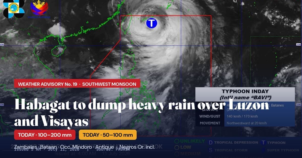
Even as Typhoon Inday tracks away from Philippine territory, the southwest monsoon it leaves supercharged in its wake is expected to dump significant rainfall across a wide arc of the country — including Negros Oriental — starting Saturday, July 11, 2026, according to the Philippine Atmospheric, Geophysical and Astronomical Services Administration (PAGASA).
PAGASA issued Weather Advisory No. 19 at 5 a.m. Saturday, placing Negros Oriental alongside dozens of other provinces under a forecast of 50 to 100 millimeters of rainfall within the day. The state weather bureau attributed the monsoon’s enhanced intensity to the lingering outer circulation of Typhoon Inday, internationally known as Bavi, even as the storm itself moves away from Philippine waters.
Negros Oriental Placed Under 50–100mm Rainfall Band
In its advisory, PAGASA grouped Negros Oriental within a broad rainfall watch zone that spans much of the Philippine archipelago. The list of affected provinces includes Metro Manila, Pangasinan, Benguet, Tarlac, Pampanga, Bulacan, Rizal, Cavite, Laguna, Batangas, Oriental Mindoro, Romblon, Palawan, Aklan, Capiz, Iloilo, Guimaras, and Negros Occidental, among many others.
A 50 to 100 millimeter rainfall accumulation over a 24-hour period is classified as potentially heavy to intense, sufficient to cause flooding in low-lying areas and trigger landslides in mountainous and elevated terrain. PAGASA cautioned that actual rainfall amounts in upland zones could exceed the forecast range, and that the hazard is further aggravated by the substantial rainfall that many communities have already absorbed over the preceding days.
Western Provinces to Take the Worst of the Monsoon
The most intense rainfall on Saturday is expected along the western coast of the country, where the habagat makes direct landfall from the South China Sea. PAGASA’s advisory placed Zambales, Bataan, Occidental Mindoro, and Antique under a heavier forecast band of 100 to 200 millimeters within the day — double the accumulation projected for Negros Oriental and neighboring provinces.
The weather bureau explained that these western-facing provinces absorb the full force of the enhanced monsoon, which continues to draw energy from the outer circulation of Typhoon Inday even as the typhoon itself retreats from Philippine airspace.
Typhoon Inday Moves Toward Taiwan and China
PAGASA’s 2 a.m. Saturday bulletin placed Typhoon Inday approximately 480 kilometers northeast of Itbayat, Batanes. At that time, the typhoon was packing maximum sustained winds of 140 kilometers per hour, with gusts reaching up to 170 km/h, and was advancing northwestward at 20 km/h.
According to PAGASA, Inday is not projected to make landfall anywhere in the Philippines. The typhoon is expected to exit the Philippine Area of Responsibility (PAR) on Saturday, after which it is forecast to move toward Taiwan and southern Japan before making landfall over mainland China on Sunday, July 12.
PAGASA records show that Inday is the ninth tropical cyclone to enter or form within the PAR in 2026 and the second for the month of July.
Multi-Day Rain Outlook: Hazard Extends Through Monday
The heavy rain pattern driven by the enhanced habagat is not limited to Saturday alone. PAGASA’s extended forecast maintains widespread rainfall warnings across multiple regions well into the following days.
On Sunday, July 12, PAGASA said Occidental Mindoro, Zambales, and Bataan will again fall under the 100 to 200 mm rainfall bracket. Areas across Central and Southern Luzon and the western Visayas — a zone that encompasses regions adjacent to Negros — are expected to remain under the 50 to 100 mm forecast through Sunday.
By Monday, July 13, the state weather bureau said the heaviest rainfall corridor narrows primarily to Zambales and Bataan, while the 50 to 100 mm band shifts to cover the Ilocos provinces, the Cordillera Administrative Region, Central Luzon, Metro Manila, the CALABARZON region, and Occidental Mindoro. The gradual narrowing of the heaviest-rain zone does not mean the hazard has passed — PAGASA noted that cumulative rainfall by Monday could still represent a significant threat to communities that have been continuously absorbing monsoon rains for several days.
Flooding and Landslide Risk Remains Elevated
Throughout the forecast period, PAGASA explicitly warned of a sustained threat of flooding and rain-induced landslides in susceptible areas. The weather bureau stressed that communities already saturated by days of antecedent rainfall are at heightened risk — a scenario where even moderate incremental rain can overwhelm drainage infrastructure and destabilize slopes.
Residents living near riverbanks, in low-lying coastal zones, and in communities situated along slopes and hillsides were advised by PAGASA to remain on heightened alert and to follow guidance issued by their respective local authorities. The bureau’s advisory made clear that the combination of ongoing monsoon activity and prior rainfall saturation creates compounding hazard conditions that demand proactive community response.
LDRRMOs on Alert; Public Reminded About Warning Levels
PAGASA directed all local disaster risk reduction and management offices (LDRRMOs) to take the necessary protective measures within their jurisdictions given the forecast hazardous weather conditions. The bureau underscored that local governments must be prepared for a multi-day rainfall event, not just a single-day weather episode.
The state weather bureau also issued an important clarification to the public on how its warning system functions. PAGASA noted that Weather Advisories — such as Advisory No. 19 — provide a broad, provincial-level, 24-hour outlook. Decisions on class suspensions or work cancellations, however, should be guided by the shorter-range, municipal-level Heavy Rainfall Warnings issued separately by PAGASA’s Regional Services Divisions, not solely by the general advisory. This distinction, PAGASA said, is critical to avoid both under-reaction and unnecessary disruption.
The weather bureau said its next advisory would be released at 11 a.m. Saturday, July 11, with an earlier update to be issued only if conditions change significantly in the meantime.
By the Numbers
- 50–100 mm: Rainfall forecast for Negros Oriental and dozens of other provinces on Saturday, July 11
- 100–200 mm: Heavier rainfall forecast for Zambales, Bataan, Occidental Mindoro, and Antique on Saturday, July 11
- 480 km: Distance of Typhoon Inday from Itbayat, Batanes, as of 2 a.m. Saturday
- 140 km/h: Maximum sustained winds of Typhoon Inday at the time of reporting
- 170 km/h: Peak gust speed of Typhoon Inday
- 20 km/h: Northwestward movement speed of Typhoon Inday
- 9th: Typhoon Inday’s count as the ninth tropical cyclone within PAR in 2026
- July 12: Projected date of Typhoon Inday’s landfall over mainland China
Why This Matters
While Typhoon Inday is departing Philippine territory without making direct landfall, its outer circulation is sustaining a powerful habagat that will continue to threaten large portions of the country — Negros Oriental among them — with heavy to intense rainfall through at least Monday, July 13. PAGASA’s explicit warning about compounded risk from days of prior rainfall underscores that flooding and landslides are active hazards, not merely theoretical ones, for many communities. The extended duration of the weather event — spanning at least three days — means that the window of danger is considerably longer than a typical single-storm scenario, making sustained vigilance and timely action by both residents and local governments essential.
Source: breakingnewsnegrosoriental.com / PAGASA Weather Advisory No. 19, July 11, 2026