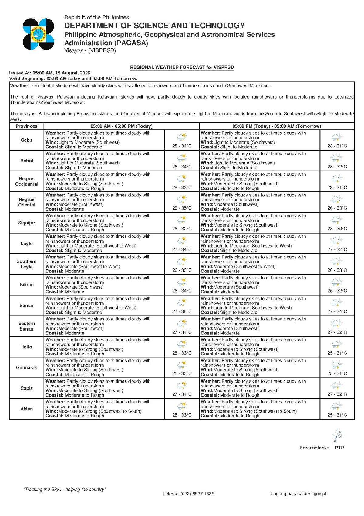
DUMAGUETE CITY, Negros Oriental — August 15, 2026 — The southwest monsoon is keeping the skies unsettled across Negros Oriental this Saturday, with the Philippine Atmospheric, Geophysical and Astronomical Services Administration (PAGASA) warning that rainshowers and thunderstorms could break out at any hour of the day. The 5:00 AM Visayas regional forecast from PAGASA described skies as partly cloudy to at times cloudy, with the possibility of sudden downpours catching residents off guard throughout the province.
The Force Behind Saturday’s Weather
PAGASA’s forecast attributes today’s unsettled conditions to the southwest monsoon, or habagat — the dominant weather driver across the Philippines during the rainy season. Winds are blowing in from the southwest at light to moderate speeds, carrying moisture-laden air from the surrounding ocean and the South China Sea landward across the Visayas.
The mechanics of habagat are straightforward: warm, wet air sweeping in from the southwest feeds cloud formation and triggers rainfall that can range from brief showers to heavy, thunderstorm-accompanied downpours. What makes habagat particularly tricky is that mornings may appear partly sunny before clouds build and showers develop rapidly by midday or afternoon. According to PAGASA, that pattern is exactly what Negros Oriental and the broader Visayas region should anticipate today.
Temperatures, Humidity, and What to Expect on the Ground
PAGASA’s forecast places Saturday’s temperature range between a warm low of 28°C early in the morning and a high of 34°C during the afternoon, if skies thin out enough to allow stronger sunshine. Combined with the elevated humidity that is characteristic of southwest monsoon season, the actual “feels-like” or heat index temperature could climb even higher than the recorded air temperature, making outdoor work and physical activity noticeably draining well before any rain arrives.
For communities across the province — including Dumaguete City, Bais, Bayawan, and Guihulngan — the day will be warm and intermittently cloudy, with no specific time window when showers are more or less likely. PAGASA’s forecast does not confine the threat of rainshowers or thunderstorms to any part of the day, which means residents and workers should stay prepared regardless of morning conditions.
Coastal Conditions: What Fisherfolk and Commuters Need to Know
PAGASA describes coastal conditions in the waters around Negros Oriental — including the Tanon Strait separating Negros from Cebu, and the sea lanes near Siquijor Island — as slight to moderate. In practical terms, this means wave heights are noticeable and the ride on small boats or bancas will be choppy and uncomfortable. For the smallest open watercraft, these conditions carry real risk, particularly if a thunderstorm squall moves through and intensifies wind and wave action suddenly.
When PAGASA labels sea state as “slight to moderate,” the agency is signaling variability: some stretches of water may be calmer while others are rougher, and conditions can deteriorate quickly when a passing shower kicks up localized gusts. The weather bureau has not issued a gale warning for this area, meaning large inter-island vessels are not under a formal travel restriction. However, PAGASA’s general caution to small boat operators remains in effect.
Residents who routinely cross to Siquijor by banca, or who fish along the coastlines of Dumaguete, Dauin, Bacong, and Zamboanguita, are advised to exercise added caution today. Thunderstorms can form rapidly under southwest monsoon conditions, and lightning represents one of the most serious weather hazards for those working on open water. If cloud cover darkens and winds shift or strengthen, getting to shore quickly is the safest course of action.
Passengers booked on ferry routes — such as those connecting Dumaguete to Cebu or to Siquijor via operators like OceanJet and Montenegro Lines — should verify vessel schedules and sailing status directly with their ferry operator before proceeding to the port, as slight to moderate sea conditions may affect comfort levels and, in some cases, departure timing.
Guidance for Farmers and Agricultural Communities
For agricultural workers in the upland barangays of Guihulngan, Tayasan, La Libertad, and other farming communities across Negros Oriental, intermittent monsoon rainfall generally supports crop growth. However, PAGASA’s warning of possible thunderstorms introduces the risk of brief but intense rainfall bursts that can cause localized flooding in low-lying farm plots or damage tender crops. Workers in open fields should keep a close eye on cloud development to the west and southwest, and seek shelter well ahead of any approaching dark cloudbanks.
Advice for Schools, Families, and Outdoor Events
With the school week in progress, parents transporting children to and from school are strongly encouraged to carry rain gear regardless of how calm the morning may appear. Habagat-driven showers are notorious for arriving with minimal advance warning. Local government units may issue class suspension advisories if rainfall becomes particularly heavy, and families should monitor official announcements throughout the day.
Event organizers, construction workers, and market vendors with outdoor activities planned in Dumaguete City or elsewhere in the province should build contingency measures into their Saturday schedules. Tent coverings, early-morning time slots, and clearly communicated shelter plans for attendees are all reasonable precautions under a forecast that PAGASA describes as including thunderstorm risk at any time of day.
Extended Outlook: Monsoon Pattern Persists
According to PAGASA’s extended weather outlook issued at 9:00 AM on Thursday, August 14, 2026, the southwest monsoon pattern is expected to persist beyond Saturday. The preceding Friday was forecast to see temperatures between 28°C and 33°C, with moderate southwest winds and moderate coastal conditions — somewhat rougher at sea than Saturday’s outlook. The following day in the extended window projects temperatures ranging from 27°C to 33°C, with light to moderate southwest winds and a return to slight to moderate coastal conditions.
PAGASA’s multi-day outlook makes clear that there is no immediate break from habagat conditions in the near term. Residents, fisherfolk, farmers, and event organizers across Negros Oriental should treat intermittent showers and the possibility of thunderstorms as the normal baseline for the coming days rather than isolated occurrences.
By the Numbers
- 28°C — forecast morning low temperature for Negros Oriental and the Visayas on Saturday
- 34°C — forecast afternoon high temperature for Saturday
- 27°C–33°C — projected temperature range for the following day in PAGASA’s extended outlook
- 28°C–33°C — projected temperature range for Friday in PAGASA’s extended outlook
- 5:00 AM — time of PAGASA’s regional Visayas forecast cited for Saturday
- 9:00 AM, August 14, 2026 — date and time of PAGASA’s extended weather outlook issuance
Why This Matters
The southwest monsoon’s sustained grip on Negros Oriental means that residents, workers, and travelers face an extended period of weather-related disruption, not a single isolated rainy day. PAGASA’s combined warning of thunderstorm risk and slight to moderate coastal conditions poses genuine safety concerns for fisherfolk, small boat operators, and outdoor workers who may underestimate how rapidly conditions can deteriorate under habagat. Staying informed through official PAGASA forecasts and local government advisories, and making simple preparations such as carrying rain gear and confirming ferry schedules, can meaningfully reduce weather-related risk throughout the monsoon season.
Source: Breaking News Negros Oriental / PAGASA regional forecast, August 15, 2026