DUMAGUETE CITY, Negros Oriental — August 14, 2026. The southwest monsoon continues to assert its grip over the Visayas this Friday, bringing with it the threat of scattered rainshowers, sudden thunderstorms, and choppy coastal waters that will affect fisherfolk, commuters, ferry passengers, and farmers throughout Negros Oriental. PAGASA’s early-morning bulletin, released at 5:00 AM, paints a picture of an unsettled but manageable day — provided residents plan carefully and stay alert to rapidly changing skies.
Here is a breakdown of what the forecast means, who it affects, and what precautions are worth taking before you step outside or head to sea.
The Weather Driver: Southwest Monsoon
PAGASA has identified the southwest monsoon — known locally as the habagat — as the primary force shaping today’s weather across the Visayas, including Negros Oriental. The habagat is a seasonal wind system that typically dominates Philippine weather from June through September, drawing warm, moisture-saturated air from the West Philippine Sea inland across the archipelago.
According to PAGASA, winds across the Visayas are blowing from the southwest at moderate speeds today. That sustained flow of wet air is responsible for the cloudiness, intermittent rain, and the atmospheric instability that can trigger sudden thunderstorm bursts — particularly during the afternoon hours when surface heating adds additional energy to an already moisture-heavy atmosphere. This is a typical mid-August pattern, PAGASA data indicates, but one that carries real risks for those working outdoors or operating vessels at sea.
Friday’s Official Forecast for Negros Oriental and the Visayas
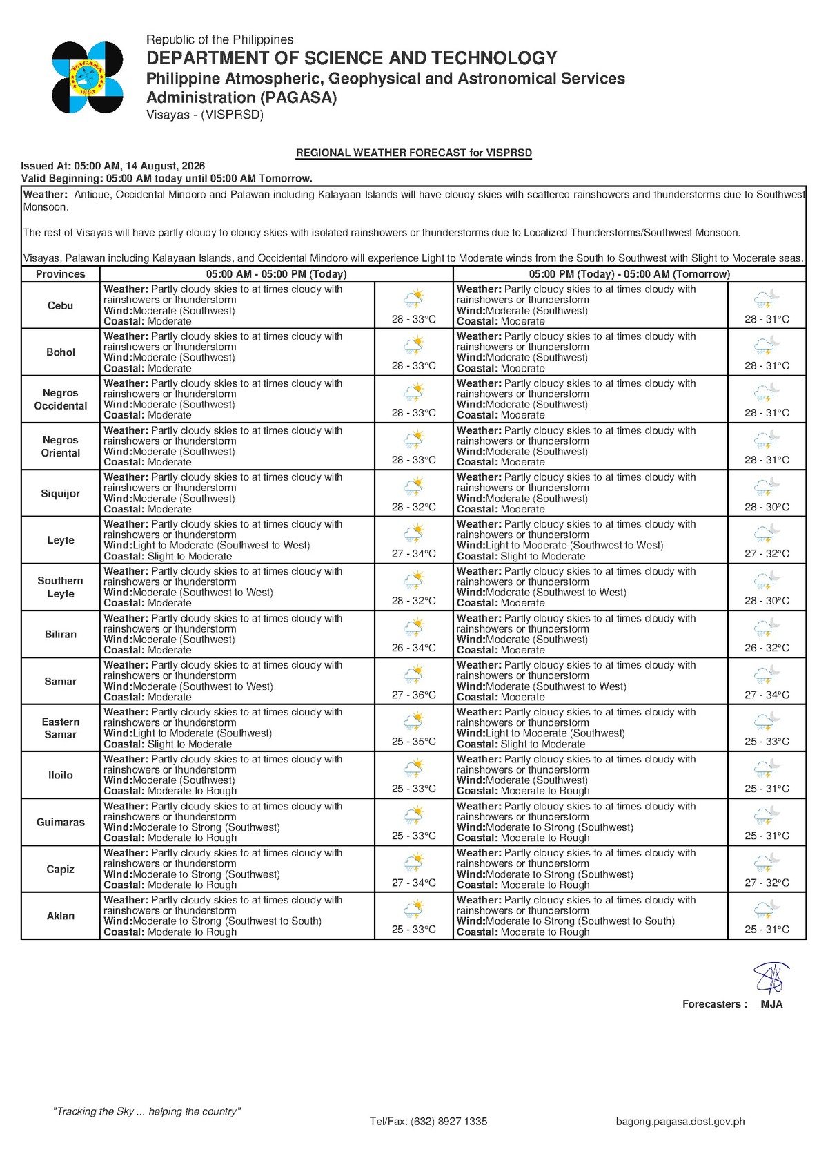
PAGASA’s 5:00 AM bulletin for August 14, 2026 covers the entire Visayas region, with conditions applying directly to Negros Oriental and surrounding areas. The agency’s forecast describes the following:
- Sky condition: Partly cloudy to at times cloudy
- Precipitation: Scattered rainshowers or thunderstorms
- Temperature: Low of 28°C, high of 33°C
- Wind direction and speed: Southwest, moderate
- Coastal waters: Moderate conditions
Rain is not expected to fall continuously throughout the day. PAGASA’s forecast suggests skies may clear temporarily between weather episodes, but isolated heavy downpours with lightning remain possible at any point — and more likely from midday onward. Cities and municipalities across the province, from Dumaguete City in the south to Guihulngan and La Libertad in the north, fall within the forecast area.
By the Numbers
- 5:00 AM — Time of PAGASA’s Friday morning forecast bulletin
- 28°C — Forecast low temperature for Negros Oriental and the Visayas
- 33°C — Forecast high temperature for the region
- 27°C–33°C — Projected temperature range for Saturday and Sunday
- 9:00 AM, August 13, 2026 — Time of PAGASA’s Extended Weather Outlook issuance covering the weekend
Sea Travel and Coastal Conditions
PAGASA has classified coastal waters across the Visayas as moderate for Friday. This rating carries real practical weight: moderate seas are rough enough to pose a genuine hazard to small, non-motorized, and overloaded watercraft, including the small bancas and open fishing boats common along Negros Oriental’s coastline.
Larger inter-island passenger ferries can typically operate under moderate coastal conditions, but the additional threat of thunderstorms — which can rapidly intensify wind gusts and wave heights with little advance warning — elevates the risk profile for today’s sea crossings. PAGASA’s forecast makes clear that conditions could deteriorate quickly if a thunderstorm develops over or near a sailing route.
Key ferry routes that passengers should monitor closely include:
- Dumaguete–Siquijor and the return crossing
- Dumaguete–Cebu routes served by FastCat, OceanJet, and other operators
- Bais–Cebu and inter-island services from northern Negros Oriental ports
Passengers are strongly advised to confirm schedules directly with their ferry operator before proceeding to the port. Operators may implement delays or cancellations if sea conditions worsen beyond what PAGASA’s current forecast projects.
What Fisherfolk and Small-Boat Operators Should Know
The combination PAGASA has flagged — moderate coastal conditions alongside the possibility of thunderstorms — is particularly serious for anyone planning to operate a small vessel today. Thunderstorms can produce sudden squalls: brief but powerful bursts of wind capable of capsizing or swamping a small banca within minutes of onset.
Fisherfolk operating along the shores of Bayawan, Bais, Zamboanguita, Siaton, and other coastal municipalities of Negros Oriental should carefully observe sky conditions before launching. PAGASA weather guidance consistently advises mariners operating small craft to avoid going far from shore during days with a thunderstorm threat. If you are already at sea and observe rapidly building dark clouds, hear distant thunder, or notice a sudden drop in visibility, return to port without delay. Do not wait for a storm to arrive overhead.
Guidance for Farmers
Habagat rains can be a welcome development for crops still in the growing season, but PAGASA’s thunderstorm forecast introduces a hazard that should not be underestimated: lightning. Open agricultural fields offer no natural protection, and isolated trees — a common impromptu shelter — actually attract lightning strikes and should be avoided during electrical storms.
Farmers in Guihulngan, La Libertad, Tayasan, Jimalalud, and other interior agricultural communities of Negros Oriental are advised to watch the sky throughout the workday and move to a sturdy, enclosed structure at the first sign of heavy cloud buildup or distant lightning. Those managing low-lying rice paddies or fields with poor drainage should also assess for localized flooding risk, as concentrated thunderstorm rainfall can overwhelm flat terrain quickly.
For Students, Parents, and Schools
Afternoon hours — typically between noon and early evening — represent the peak period for thunderstorm development on days shaped by habagat conditions, as daytime ground heating amplifies the moisture already present in the air. This timing coincides with school dismissal hours across many parts of Negros Oriental.
Parents of students who walk or ride motorcycles home, and school administrators monitoring dismissal logistics, should keep a close eye on conditions as the afternoon progresses. If a thunderstorm is actively developing at dismissal time, sheltering students on campus until the worst of it passes is the safer course of action. PAGASA’s forecast makes clear that afternoon intensity cannot be ruled out.
Commuters and Outdoor Workers
For residents commuting within Negros Oriental today — whether by motorcycle, tricycle, jeepney, or on foot — carrying rain gear is a practical must. Morning hours may be relatively dry, but the day’s forecast offers no guarantee of a clear afternoon. Construction workers, utility crews, and anyone whose work takes place in open or elevated areas should have a clear plan for finding shelter if lightning is sighted or thunder is audible. PAGASA guidance advises going indoors or into a hard-topped vehicle and avoiding open structures, metal objects, and bodies of water during lightning activity.
Weekend Outlook
According to PAGASA’s Extended Weather Outlook, which the agency issued at 9:00 AM on August 13, 2026, the pattern now affecting Negros Oriental and the Visayas is not expected to break significantly over the coming days. The agency’s projections for the weekend indicate:
- Saturday, August 15: Temperatures of 27°C to 33°C; moderate southwest winds; moderate coastal conditions
- Sunday, August 16: Temperatures of 27°C to 33°C; moderate southwest winds; moderate coastal conditions
PAGASA’s available data shows no forecast for a sharp improvement or a significant deterioration through the weekend. Residents, travelers, and those with outdoor plans or sea-based activities scheduled for Saturday or Sunday should plan with the same level of caution applied to Friday — intermittent rainshowers, possible thunderstorms, and choppy coastal waters remain on the table for all three days.
Why This Matters
The southwest monsoon pattern PAGASA has flagged for August 14–16, 2026 carries meaningful risk for communities across Negros Oriental whose daily livelihoods depend on sea access, open-field agriculture, and road-based commuting. Moderate coastal conditions combined with a thunderstorm threat represent a compounded hazard for small-vessel operators — the population segment most vulnerable to sudden weather changes at sea. For the broader public, PAGASA’s forecast underscores the importance of real-time weather awareness during the height of the habagat season, when rapid-onset thunderstorms can escalate quickly from inconvenience to genuine danger.
Source: Breaking News Negros Oriental (breakingnewsnegrosoriental.com), based on PAGASA forecast data issued August 13–14, 2026.