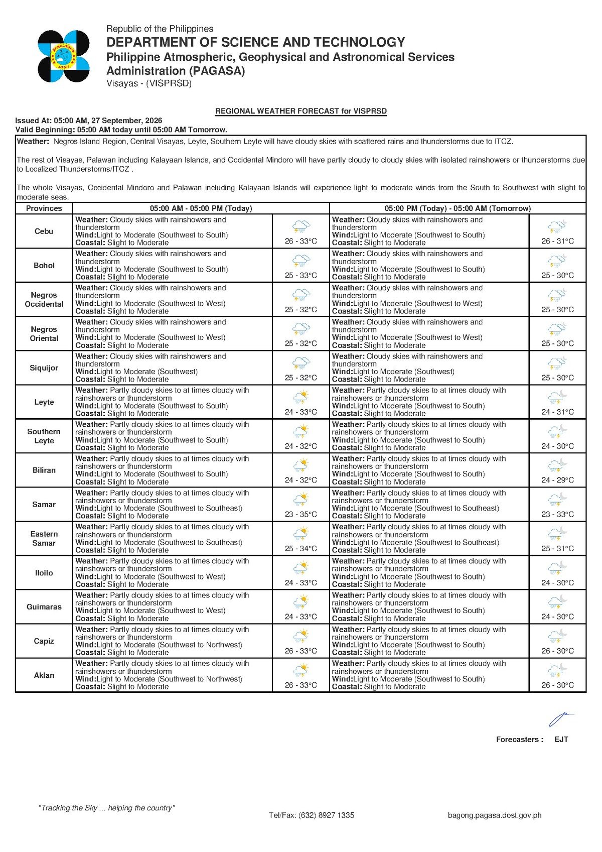
DUMAGUETE CITY, Negros Oriental — September 27, 2026 — A wet and unsettled Sunday is in store for Negros Oriental and the rest of the Visayas region, with the Philippine Atmospheric, Geophysical and Astronomical Services Administration (PAGASA) placing the entire area under a forecast of cloudy skies, rainshowers, and thunderstorms. The official bulletin, released at 5:00 AM on September 27, 2026, covers Negros Oriental, Siquijor, Cebu, and other Visayas provinces, signaling that residents, commuters, fisherfolk, and travelers should prepare for disrupted conditions throughout the day.
By the Numbers
- Forecast bulletin issued at 5:00 AM, September 27, 2026
- Temperature range: 26°C to 33°C
- Coastal wave heights: 0.5 to 1.25 meters (slight) up to 2.5 meters (moderate)
- Extended outlook reference bulletin issued: 9:00 AM, September 26, 2026
Weather Drivers: Habagat at Work
According to PAGASA, winds are blowing from the southwest to south at light to moderate speeds — a pattern strongly associated with the southwest monsoon, known locally as habagat. This large-scale seasonal wind system draws warm, moisture-rich air from the surrounding seas onto the Philippine landmass during the rainy season, generating the cloud cover and atmospheric instability that fuels rainshowers and thunderstorms across the Visayas. PAGASA’s official bulletin does not designate a named tropical weather system in the raw data available for this forecast period, and readers are advised to visit pagasa.dost.gov.ph directly to check for any updated system advisories.
The moisture content in the atmosphere is high enough to produce not just intermittent showers, but genuine thunderstorm activity — events that bring lightning, heavy short-duration rainfall, and sudden gusts of wind. PAGASA cautions that these conditions can shift quickly, and monitoring updated forecasts throughout the day remains important.
Provincial Conditions: From Coast to Interior
Across Negros Oriental — from Dumaguete’s urban center and the coastal communities of Bayawan and Bais in the south, to the upland towns surrounding Guihulngan and Valencia in the interior — PAGASA’s forecast paints a consistent picture of overcast skies with periodic rainshowers and the threat of thunderstorms at any hour of the day. The province’s coastal exposure along the Tañon Strait and the Bohol Sea adds another layer of concern, as wind-driven swells and open-water chop pose genuine hazards for small watercraft.
On the island of Siquijor, the same conditions prevail — cloudy, showery, and thunderstorm-prone — making the inter-island crossing between Siquijor and Dumaguete a trip that should be planned with weather updates in hand. Passengers traveling to or from Cebu should likewise anticipate possible weather-related delays at sea and on the road.
Inland and upland areas, particularly the mountain barangays that border Dumaguete’s neighboring municipalities and the elevated terrain around Valencia, are susceptible to heavier localized downpours when thunderstorm cells develop overhead. PAGASA advises that residents in lower-lying zones near these areas remain alert to rising drainage levels and localized flooding.
What the Forecast Language Really Means
PAGASA describes today’s outlook using standard meteorological terminology that can sometimes be unclear to the general public. Here is a plain-language breakdown of what those terms mean in practice:
Rainshowers are not a steady, all-day downpour. They are intermittent bursts of rain that can last anywhere from a few minutes to over an hour. A break between showers does not mean conditions have improved — another band of rain can follow quickly, and intensity can vary significantly from one shower to the next.
Thunderstorms represent a more serious category of weather event. PAGASA uses this term to describe conditions that include lightning, thunder, stronger wind gusts, and concentrated heavy rainfall within a short window. Lightning is an immediate life safety hazard: if thunder is audible, a person is already within striking range. Taking shelter inside a sturdy structure — away from windows, metal objects, and standing water — is the recommended response.
Slight to moderate coastal conditions, as classified by PAGASA, refer to wave heights ranging from approximately 0.5 to 1.25 meters at the lower end and up to 2.5 meters at the moderate level. For the small wooden bangkas and outrigger fishing boats common to Negros Oriental’s coastal villages, moderate wave heights combined with gusty thunderstorm winds can be genuinely life-threatening.
Light to moderate winds from the southwest to south may appear manageable under normal circumstances, but PAGASA notes that these speeds can intensify rapidly as thunderstorm cells develop and pass through. Travelers on open water should not treat current wind readings as a guarantee of safety for the duration of the day.
Sector-by-Sector Advisory
Ferry Passengers and Sea Travelers
Those planning inter-island travel today — whether aboard OceanJet, Montenegro Lines, or smaller pump boats serving routes between Dumaguete, Siquijor, and Cebu — should verify vessel status directly with their ferry operators before departing for the port. PAGASA’s slight-to-moderate coastal classification can result in schedule delays, early voyage curfews, or cancellations for smaller craft. Carry documents in waterproof pouches, arrive at the terminal early, and always follow the safety instructions of vessel crew. If a captain decides conditions are unsafe for departure, that judgment should be respected without question.
Fisherfolk and Coastal Boat Operators
For fishing communities in Dumaguete, Bayawan, Bais, Manjuyod, and other coastal municipalities of Negros Oriental, today’s combination of moderate sea conditions and active thunderstorm risk makes this a high-caution day on the water, according to the PAGASA forecast. If going out is unavoidable, staying close to shore and monitoring sky and wind conditions continuously is essential. Open water during a thunderstorm — particularly in a metal-hulled or electrically conducting vessel — carries a serious lightning strike risk that no catch can justify.
Farmers and Agricultural Workers
Sugar cane planters, rice farmers, and vegetable growers across Negros Oriental’s lowlands and hillside farms should expect wet field conditions throughout the day. Thunderstorm episodes can bring bursts of heavy rain that may cause localized flooding in low-elevation agricultural land. PAGASA advises avoiding open field work during active lightning — elevated and exposed terrain amplifies the risk significantly. Field operations or harvests that can reasonably be deferred should be scheduled for a day with a clearer outlook.
Students, Families, and Outdoor Events
Any Sunday outdoor gatherings — sports events, school fairs, or community functions — should have covered-venue contingency plans in place. Thunderstorms can develop with little advance warning, and open venues offer no protection from lightning. Parents are urged to keep children indoors during active thunder and lightning episodes, even when rainfall at a given moment appears light.
Commuters and Pedestrians
Those moving through Dumaguete and other Negros Oriental towns today — whether by habal-habal, tricycle, jeepney, or on foot — should carry a reliable rain covering. Roads become slippery rapidly during heavy showers, and low-lying streets and underpasses are vulnerable to flash flooding during thunderstorm-associated downpours. PAGASA urges the public to avoid walking through flooded sections of road, as even shallow standing water can conceal open drainage channels or carry enough current to knock a person off balance.
Looking Ahead
PAGASA’s Extended Weather Outlook, issued at 9:00 AM on September 26, 2026, provides additional guidance on conditions expected in the days following Sunday. Residents and planning offices are encouraged to consult the agency’s official channels — including the PAGASA website at pagasa.dost.gov.ph and its verified social media pages — for the most current multi-day forecasts, as conditions may evolve beyond the scope of this bulletin.
Why This Matters
Negros Oriental is a province with extensive coastlines, active fishing communities, and significant inter-island ferry traffic — all of which are directly affected when PAGASA issues a forecast combining thunderstorms with slight-to-moderate coastal wave conditions. The simultaneous risk to sea travel, agricultural operations, and public safety on land makes this forecast relevant to a wide cross-section of the provincial population. Timely awareness of PAGASA’s advisories allows residents, ferry operators, fisherfolk, and local government units to make informed decisions that can prevent weather-related injuries and economic losses.
Source: breakingnewsnegrosoriental.com / PAGASA official forecast bulletin, September 27, 2026