The Philippine Atmospheric, Geophysical and Astronomical Services Administration (PAGASA) has placed the entire Philippine archipelago on alert for scattered to isolated thunderstorms on Sunday, June 14, 2026, with conditions expected to be harshest over the western portions of Mindanao. The state weather agency released its 24-hour public weather forecast at 4:00 AM Sunday, covering the period through 4:00 AM on Monday, June 15.
According to PAGASA, two weather drivers are at work simultaneously: the easterlies — seasonal winds originating from the Pacific Ocean — which are pushing wet conditions across Mindanao, Eastern Visayas, and parts of Southern Luzon; and localized thunderstorm development, which will extend rain chances to Metro Manila and nearly every other corner of the country throughout the day.
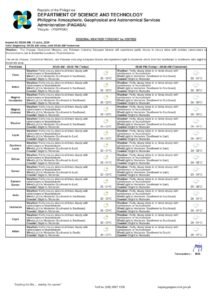
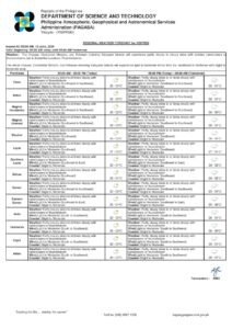
Western Mindanao Faces the Most Severe Conditions
PAGASA singled out Zamboanga Peninsula, Basilan, and Tawi-Tawi as the areas most likely to bear the brunt of Sunday’s weather. The agency forecasts cloudy skies with scattered rains and thunderstorms for these provinces, with the easterlies cited as the primary forcing mechanism behind the persistent wet weather in the southern Philippines.
Of particular concern, PAGASA warned of the potential for flash floods and landslides resulting from moderate to occasionally heavy rainfall. Communities situated along riverbanks, low-lying coastal strips, and sloped or mountainous terrain — specifically in Zamboanga del Norte, Zamboanga del Sur, Zamboanga Sibugay, Basilan, and the Tawi-Tawi island group — were urged to keep a close watch on developing conditions and to remain in contact with their respective local disaster risk reduction and management offices for the latest advisories.
Elsewhere in Mindanao, including the Davao Region, Soccsksargen, Caraga, Northern Mindanao, and most of the Bangsamoro Autonomous Region in Muslim Mindanao (BARMM), PAGASA projects partly cloudy to cloudy skies with isolated rainshowers or thunderstorms. Although rainfall frequency is expected to be lower compared to western Mindanao, the state weather bureau cautioned that flash floods and landslides could still occur in areas that experience intense thunderstorm episodes.
Visayas: Eastern Provinces Directly Under Easterly Influence
The Eastern Visayas sub-region — comprising Leyte, Southern Leyte, Samar, Eastern Samar, Northern Samar, and Biliran — is forecast by PAGASA to have partly cloudy to cloudy skies with isolated rainshowers or thunderstorms on Sunday, driven directly by the easterlies. As in Mindanao, the agency flagged flash floods and landslides as potential hazards should any thunderstorm system intensify.
The remainder of the Visayas — covering Western Visayas provinces such as Iloilo, Capiz, Aklan, Antique, and Guimaras, as well as Central Visayas including Cebu, Bohol, Negros Oriental, and Siquijor — will see partly cloudy to cloudy skies with isolated rainshowers or thunderstorms linked to localized thunderstorm development. PAGASA reminded all Visayas residents to stay alert to rapidly deteriorating weather, especially during the afternoon and early evening hours when convective activity typically peaks.
Luzon: Isolated Storms to Affect Metro Manila and Most Provinces
For Metro Manila and the broader Luzon island group, PAGASA’s forecast calls for partly cloudy to cloudy skies with isolated rainshowers or thunderstorms on Sunday, June 14. The weather bureau attributed this activity primarily to localized thunderstorm development rather than any large-scale weather disturbance, meaning rainfall distribution will be patchy — certain areas may receive short but intense downpours while neighboring communities stay mostly dry.
The easterlies also reach into eastern Southern Luzon, affecting Quezon province, Aurora, and the Pacific-facing portions of the Bicol Region. The entire Bicol Region — spanning Camarines Norte, Camarines Sur, Albay, Sorsogon, Catanduanes, and Masbate — is placed under a similar outlook of partly cloudy to cloudy skies with isolated rainshowers or thunderstorms, along with flash flood and landslide advisories during severe thunderstorm periods, according to PAGASA.
In Northern Luzon, areas under the Ilocos Region, Cagayan Valley, the Cordillera Administrative Region, and Central Luzon will likewise experience isolated rainshowers and thunderstorms fueled by localized atmospheric activity. PAGASA noted that afternoon thunderstorms are a seasonal norm at this time of year, and stressed that even isolated storms are capable of producing sudden, intense flooding in urban centers and low-lying communities.
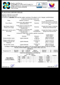
Temperature Readings and Humidity Levels
PAGASA’s weather instruments at Science Garden in Diliman, Quezon City logged a peak temperature of 32.5 degrees Celsius at 11:00 AM on Saturday, June 13, while the overnight low dipped to 26.2 degrees Celsius at 5:00 AM the same morning. Relative humidity swung between 92 percent at 5:00 AM and 62 percent at 11:00 AM, reflecting the characteristically warm and muggy atmospheric conditions that Metro Manila experiences during June.
Across the country, residents can expect humid and uncomfortable conditions during dry spells between rain events, with temperatures and heat index values likely climbing through the late morning before the arrival of afternoon thunderstorms offers brief respite.
Wind Patterns and Sea Conditions
PAGASA reported that winds over the Philippines on Sunday will be light to moderate in intensity. Northern Luzon and the western sections of Central and Southern Luzon will be under south to southwest wind flow, while the rest of the archipelago will experience southwest to southeast winds.
At sea, coastal waters will range from slight to moderate. Wave heights of 0.6 to 1.8 meters are forecast for the waters off Northern Luzon and the western coastlines of Central and Southern Luzon — conditions that may still be hazardous for smaller watercraft. The remaining coastal zones of the country will see wave heights between 0.6 and 1.2 meters. PAGASA advised fisherfolk and operators of small boats to exercise caution throughout the day, particularly near Mindanao where thunderstorm frequency is higher.
Sunrise, Moonrise, and Tidal Data for Metro Manila
According to PAGASA, Sunday’s sunrise over Metro Manila will occur at 5:27 AM, with sunset at 6:26 PM, providing residents with close to 13 hours of natural daylight. The moon will rise at 4:05 AM and set at 5:39 PM, with only one percent illumination — effectively a new moon phase — making Sunday night especially dark.
Tidal predictions for Manila Bay, as provided by PAGASA with data courtesy of the National Mapping and Resource Information Authority (NAMRIA), indicate a high tide of 1.35 meters at 8:23 AM and a significant low tide of -0.2 meters at 5:01 PM on Sunday. Those with activities near or along Manila Bay are advised to take these tidal swings into account, especially the notably low afternoon tide.
Key Safety Reminders from PAGASA
PAGASA identified flash floods and landslides as the primary weather-related hazards facing the public on Sunday. While the risks are most acute in Zamboanga Peninsula, Basilan, and Tawi-Tawi, the agency emphasized that severe thunderstorm episodes anywhere in the country can produce similar dangers without much warning.
Residents living in flood-prone zones or near slopes, hillsides, and elevated terrain are strongly encouraged to stay informed through official channels and to comply immediately with any evacuation directives from local authorities. Motorists are reminded to avoid flooded roadways and underpasses, and families are urged to monitor the weather closely before allowing children to engage in any planned outdoor activities.
For continuous updates, PAGASA directs the public to its official website at pagasa.dost.gov.ph and to its official social media platforms for real-time weather bulletins and warnings throughout the day.
Source: Originally reported by BreakingNewsEnglish / wire reports