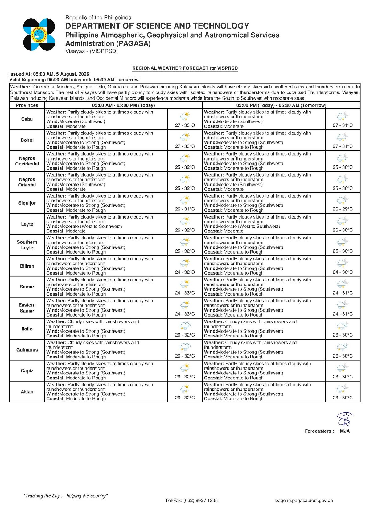
DUMAGUETE CITY, Negros Oriental — An unsettled day is in store for communities across Negros Oriental on Wednesday, August 5, 2026. The Philippine Atmospheric, Geophysical and Astronomical Services Administration (PAGASA) issued its 5:00 AM regional forecast for the Visayas signaling partly cloudy to at times cloudy skies, with rain showers and thunderstorms likely to develop at various points throughout the day. Southwest monsoon winds are currently pushing warm, moisture-heavy air over the archipelago, setting the stage for intermittent downpours that could affect everything from morning commutes to inter-island sea travel.
No tropical cyclone or low-pressure area is mentioned in PAGASA’s Visayas regional forecast for this date. All rain and storm activity is being driven entirely by the prevailing habagat, or southwest monsoon — the dominant seasonal wind pattern over the Philippines between June and September.
By the Numbers
- Forecast issued at 5:00 AM, August 5, 2026 by PAGASA
- Extended outlook issued at 9:00 AM, August 4, 2026
- Wednesday temperature range: 27°C (low) to 33°C (high)
- Thursday temperature range: 26°C (low) to 30°C (high), with moderate-to-strong southwest winds
- Further outlook for Thursday: 26°C to 32°C, continued southwest wind influence
- Coastal waters today: rated moderate; trending toward moderate-to-rough in coming days
What Is Behind Today’s Weather
According to PAGASA, the wind flow across the Visayas is coming from the southwest — a hallmark signature of the habagat season. This monsoon system draws warm, moisture-laden air from the surrounding seas and pushes it inland over the Philippine islands, where it encounters elevated terrain and triggers cloud formation. For Negros Oriental — a province defined by a mountainous interior and a long coastline — this type of atmospheric setup consistently produces bouts of localized, heavy rainfall even when the sky does not appear fully overcast.
The PAGASA forecast notes that winds across the region are blowing at moderate speed from the southwest. Coastal waters are currently rated moderate, which is manageable for larger vessels but still warrants vigilance for small boat operators. The weather agency advises small craft operators to exercise caution under these conditions.
Full Forecast Picture for the Visayas
PAGASA’s regional bulletin, released at 5:00 AM on August 5, covers the Visayas as a whole, with the following conditions expected today:
- Sky: Partly cloudy to at times cloudy
- Rain: Showers or thunderstorms likely
- Temperature: 27°C to 33°C
- Wind direction and speed: Southwest, moderate
- Coastal waters: Moderate
Across the major urban centers of Negros Oriental — Dumaguete City, Bayawan City, Bais City, and Guihulngan City — residents should be prepared for sudden heavy downpours that can strike at any time of the day. Siquijor Island, which lies just across a narrow channel from southern Negros Oriental, is under the same forecast conditions, and those planning sea crossings between the two provinces should check current wave and wind reports before departing.
Cebu province, on the opposite side of the Tañon Strait, falls under the same regional forecast umbrella. Travelers bound for Cebu aboard inter-island ferries departing from Dumaguete should factor today’s weather into their travel planning.
Short-Range Outlook: Days Ahead
According to PAGASA’s extended weather outlook, which was issued at 9:00 AM on August 4, 2026, conditions over the Visayas are expected to shift in the next 48 hours:
- Wednesday, August 5 (today): 27°C to 33°C; moderate southwest winds; moderate coastal waters
- Following day: Temperatures easing to 26°C to 30°C; winds increasing to moderate-to-strong from the southwest; coastal conditions deteriorating to moderate-to-rough
- Thursday: 26°C to 32°C; continued southwest monsoon influence on winds and weather
The anticipated strengthening of winds and worsening of sea conditions in the short term is a trend that fisherfolk, shipping operators, and regular inter-island commuters should begin tracking closely. While the sea remains at a moderate rating today, PAGASA’s extended outlook signals a deteriorating pattern in the days that follow.
Practical Guidance by Sector
Commuters and Road Users
Motorcycles and tricycles — the most common forms of daily transport in Negros Oriental — become significantly more hazardous on rain-slicked roads. Residents commuting in Dumaguete City or traveling along mountain routes between Dumaguete and Bayawan or Guihulngan should carry rain gear and allow extra travel time. Low-lying barangays in Dumaguete are prone to rapid surface flooding during intense thunderstorm bursts, so motorists should be alert to sudden changes in road conditions. Leaving earlier than usual is strongly advised.
Fisherfolk and Small Vessel Operators
Coastal waters off Negros Oriental — encompassing the Tañon Strait, areas off Bayawan and Bais, and the Siquijor Channel — are presently rated at a moderate level. Small motorized fishing bancas can generally operate in these conditions, but PAGASA cautions all small craft operators to remain watchful, particularly when thunderstorms begin to develop, as conditions can shift rapidly. Fisherfolk planning overnight or multi-day trips should take note of the forecast shift toward moderate-to-strong winds and rougher seas beginning Thursday.
Inter-Island Ferry Passengers
Ferry routes departing from Dumaguete Port — including vessels bound for Siquijor, Cebu, and Dapitan — are operating under moderate coastal conditions today, according to the PAGASA bulletin. Passengers are encouraged to coordinate directly with their shipping lines or ferry operators, including carriers such as OceanJet and other services based at Dumaguete Port, to confirm schedules and check for weather-related adjustments. Crossings are currently feasible, but travelers should allow buffer time in case of weather-related holdups. The projected deterioration to moderate-to-rough seas in coming days may affect Thursday schedules.
Farmers
Agricultural communities in Negros Oriental’s inland valleys and foothills — particularly in areas like Guihulngan, Tayasan, and Manjuyod — will experience the intermittent rains typical of southwest monsoon weather. While regular soil moisture at this stage of the rainy season generally benefits rice, sugarcane, and vegetable crops, prolonged heavy rainfall in mountainous catchment zones can cause flash flooding in low-lying farm fields. Farmers who have recently transplanted seedlings should check field drainage, and any scheduled fertilizer or pesticide applications should be postponed on days when thunderstorms are in the forecast, as rainfall will wash the chemicals away before they take effect.
Students, Parents, and Schools
Parents preparing children for school today should ensure they are equipped with rain gear. In communities where school routes cross rivers or pass through flood-prone low-lying areas, parents are encouraged to monitor local conditions closely throughout the morning hours. School administrators in vulnerable communities should follow advisories from local government units and PAGASA. No class suspensions have been issued based on the current forecast, but the likelihood of afternoon thunderstorms means the weather situation could evolve quickly.
Outdoor Workers and Event Organizers
Construction workers, outdoor market vendors, and organizers of community activities in Dumaguete, Bais, or any other part of Negros Oriental should make contingency plans for the possibility of rain and thunderstorms disrupting operations at any point during the day. Lightning that accompanies thunderstorm activity poses a direct safety hazard to anyone working outdoors or sheltering in open structures. All individuals in exposed areas are strongly advised to move to sturdy covered shelter immediately upon observing lightning or hearing thunder.
Why This Matters
The southwest monsoon consistently brings some of the most active weather of the year to the Visayas, and Negros Oriental’s combination of mountainous terrain and extensive coastline makes it especially vulnerable to localized flooding, rough seas, and disrupted transportation. PAGASA’s forecast of strengthening winds and worsening coastal conditions over the next 48 hours signals that the risk to fisherfolk, ferry passengers, and agricultural communities is set to increase, not decrease, in the short term. Residents, operators, and local authorities should stay current with PAGASA updates and act on advisories promptly to reduce risk to life and livelihood.
Source: breakingnewsnegrosoriental.com