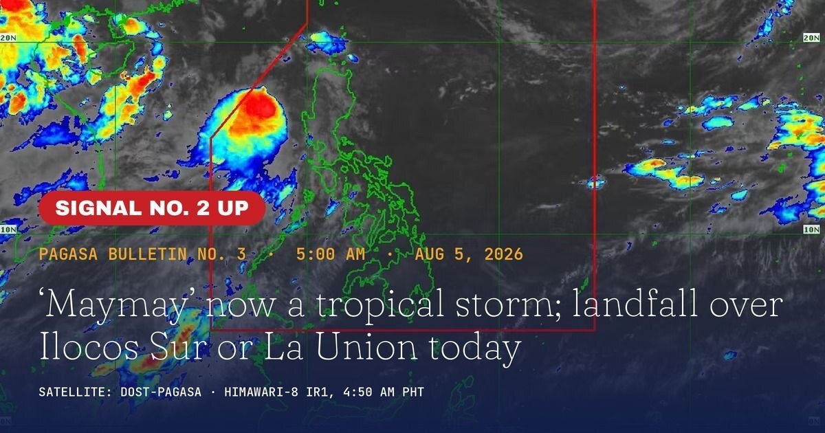
Northern Luzon braced for a direct hit Wednesday, August 5, 2026, as Tropical Storm Maymay — carrying the international name Kujira — gained strength over the West Philippine Sea and hurtled toward the coastlines of Ilocos Sur and La Union. The Philippine Atmospheric, Geophysical and Astronomical Services Administration (PAGASA) warned that landfall was expected sometime in the afternoon or evening hours of the same day.
The storm’s arrival marks a significant weather event for the region, with gale-force winds, dangerous surf, and monsoon-amplified rainfall threatening lives and properties across a wide swath of Northern and Central Luzon.
Where Maymay Was at Dawn
In its early-morning advisory, PAGASA placed Maymay’s center at 170 kilometers west northwest of Bacnotan, La Union, as of 5:00 a.m. Wednesday. The storm was tracking slowly in a southeastward direction at the time, with its strong wind field extending up to 180 kilometers outward from the center — a radius wide enough to bring damaging conditions to multiple provinces even before the eye makes contact with land.
PAGASA traced Maymay’s origins to a low pressure area that developed off La Union at 8:00 p.m. on Tuesday, August 4. It is the second tropical cyclone to form inside the Philippine Area of Responsibility this month and the 13th of the year overall.
Signal No. 2 Areas: Where Gale Winds Are Expected
PAGASA hoisted Wind Signal No. 2 over several localities, where sustained gale-force winds of 62 to 88 kilometers per hour are forecast to hit within 24 hours of the bulletin. The weather bureau identified the following areas under this signal level:
- Central and southern Ilocos Sur, including Vigan and Candon cities
- Northern and central La Union, including San Fernando City
- Northwestern Pangasinan towns — Anda, Bolinao, and Bani
- Southwestern Abra, including Bangued
- Western Mountain Province towns of Besao and Tadian
- Northwestern Benguet, including Mankayan
These areas face a minor to moderate threat to life and property, according to the PAGASA wind signal classification system.
Broad Signal No. 1 Coverage Stretches Across Luzon
Wind Signal No. 1 — representing a minimal to minor threat — was extended over a substantially larger territory. According to PAGASA, the full list includes Ilocos Norte, the remaining portions of Ilocos Sur not already under Signal No. 2, the rest of La Union, and the entirety of Pangasinan, Abra, Mountain Province, and Benguet. Cordillera provinces including Apayao, Kalinga, and Ifugao also fall under Signal No. 1, along with Cagayan, Isabela, Quirino, and Nueva Vizcaya in the Cagayan Valley region.
Signal No. 1 coverage further extends southward into Central Luzon, with portions of Zambales, Tarlac, Nueva Ecija, and Aurora also placed on alert, PAGASA confirmed.
Landfall Projected Wednesday; Storm to Weaken by Thursday
The state weather bureau forecast that Maymay would cross the Northern Luzon coastline — most likely along Ilocos Sur or La Union — during Wednesday afternoon or evening. Following landfall, the storm is expected to move across the landmass of Northern and Central Luzon throughout the day on Thursday, August 6.
PAGASA projected that Maymay would downgrade to a tropical depression by Thursday morning, then further deteriorate into a low pressure area by Thursday afternoon or evening as it continues its inland track and loses its organized structure. Gusty and wet weather, however, is expected to linger across much of the country through Thursday and Friday.
Dangerous Seas Off the Western Luzon Seaboard
A gale warning is currently in force over the western coastal waters of Northern Luzon, PAGASA announced. Waves off Ilocos Sur, La Union, and Pangasinan could swell to as high as 4.5 meters — conditions that render sea travel extremely hazardous regardless of vessel type or tonnage.
The weather bureau issued a categorical directive for all mariners to stay in port or secure shelter in safe harbor and to refrain from venturing out until conditions have substantially improved. Fishing and passenger vessels operating along these coastal routes were specifically cautioned.
Southwest Monsoon to Spread Storm Effects Widely
PAGASA noted that Maymay’s interaction with the Southwest Monsoon will substantially broaden the storm’s weather footprint. Strong to gale-force gusts are expected to sweep across most of Luzon and extend into the Visayas on Wednesday as the monsoon draws energy from the cyclone’s outer circulation.
Several Mindanao provinces are also expected to experience these enhanced conditions, including Surigao del Norte, Dinagat Islands, Misamis Occidental, Camiguin, Lanao del Norte, Sarangani, Davao Occidental, and Davao Oriental, according to the weather agency. The monsoon’s influence is expected to keep conditions rough across a large portion of the archipelago through the latter part of the week.
Residents in Flood- and Landslide-Prone Areas Urged to Stay Alert
PAGASA called on residents living in localities highly vulnerable to flooding and landslides to closely monitor official weather updates and to heed all evacuation directives issued by their respective local government units. The weather bureau scheduled its next public storm bulletin for 8:00 a.m. Wednesday, with updates to follow at regular intervals.
By the Numbers
- 170 km — distance of Maymay’s center west northwest of Bacnotan, La Union, at 5:00 a.m. Wednesday
- 180 km — radius of strong winds extending outward from the storm’s center
- 62–88 kph — gale-force wind speeds forecast for areas under Wind Signal No. 2
- 4.5 meters — maximum projected wave height off Ilocos Sur, La Union, and Pangasinan
- 13th — Maymay’s count as the 13th tropical cyclone to enter or form inside the Philippine Area of Responsibility in 2026
- August 6 — projected date for the storm’s further degradation into a low pressure area
Why This Matters
With landfall imminent over heavily populated coastal provinces, Tropical Storm Maymay poses an immediate danger to communities across Northern Luzon, including the urban centers of Vigan, Candon, and San Fernando City — all of which are under Wind Signal No. 2. Seas surging up to 4.5 meters make maritime routes along the western Luzon seaboard extremely perilous, cutting off a key mode of transportation and supply for affected communities. The storm’s amplification of the Southwest Monsoon pushes hazardous weather conditions well beyond its direct track, placing millions across Luzon, the Visayas, and parts of Mindanao under heightened risk of flooding, landslides, and storm-related accidents simultaneously.
Source: PAGASA / wire reports