QUEZON CITY, June 13, 2026 — The Philippine Atmospheric, Geophysical and Astronomical Services Administration (PAGASA) has placed communities in several eastern regions of the country on alert for possible flash floods and landslides as easterly winds channel moisture-laden rains and thunderstorms across key parts of Luzon, Visayas, and Mindanao. The state weather agency released its 24-hour public forecast at 4:00 AM on June 13, 2026, covering the period through 4:00 AM on June 14.
While the majority of the archipelago can expect only scattered or isolated showers, PAGASA emphasized that areas directly in the path of the easterlies — notably the Bicol Region, Eastern Visayas, the Davao Region, and Caraga — face a more pronounced threat from moderate to occasionally heavy downpours that could trigger dangerous flooding and soil movement in low-lying and mountainous communities.
What Is Driving the Weather
According to PAGASA, the dominant weather system at play on this date is the easterlies — eastward-originating winds that are pushing significant moisture into the eastern sections of Southern Luzon, the Visayas island group, and Mindanao. This wind pattern is characteristic of the wet season and has the effect of concentrating rainfall activity along the eastern seaboard of the country.
For areas outside the direct influence of the easterlies — including Metro Manila and most of western Luzon — PAGASA said localized convective activity, or thunderstorm development driven by heat and humidity, will account for any rain expected during the day. This is a common pattern during the Philippine summer-to-wet-season transition.
Luzon Weather Breakdown
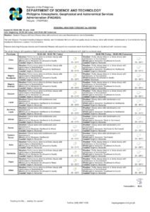
Bicol Peninsula
PAGASA forecasts cloudy skies with scattered rains and thunderstorms for the entire Bicol Region on Sunday. The weather bureau warned that moderate to at times heavy rainfall could set off flash floods and landslides across the peninsula. Residents in the provinces of Albay, Camarines Sur, Camarines Norte, Sorsogon, Catanduanes, and Masbate — especially those living along riverbanks, coastal areas, and hilly terrain — are strongly urged to remain alert and stay away from flood-prone and landslide-susceptible zones.
Far Northern Luzon
Communities in the northernmost reaches of Luzon, including those in the Ilocos Region, Cagayan Valley, and the Cordillera Administrative Region, can expect partly cloudy to cloudy skies with isolated rainshowers or thunderstorms brought about by the easterlies, PAGASA said. Although the intensity is milder compared to Bicol or Mindanao, the weather agency cautioned that flash floods and landslides remain a risk during severe thunderstorm episodes. Residents in highland and riverine communities are advised to keep a close watch on rainfall conditions.
Metro Manila and Remaining Luzon Areas
The national capital region and surrounding provinces will experience partly cloudy to cloudy skies with isolated rainshowers or thunderstorms, according to PAGASA, largely driven by localized thunderstorm development. While the probability of significant rainfall is lower than in the eastern regions, the agency reminded the public that flash floods and landslides are still possible during severe thunderstorm episodes. Urban flooding in Metro Manila — a persistent concern given its drainage challenges — remains a hazard during intense, concentrated downpours.
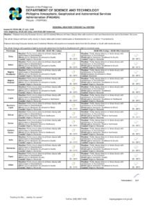
Visayas Weather Breakdown
Eastern Visayas
Among the regions most directly exposed to the easterlies, Eastern Visayas — covering Leyte, Southern Leyte, Samar, Eastern Samar, Northern Samar, and Biliran — will see cloudy skies with scattered rains and thunderstorms on Sunday. PAGASA flagged the threat of flash floods and landslides stemming from moderate to at times heavy rainfall in the region, which has a well-documented history of rainfall-related disasters. Local government units and residents are urged to heed all official advisories and be prepared to evacuate if conditions worsen.
Western Visayas
The western portions of the Visayas will be under somewhat lighter conditions, with PAGASA projecting partly cloudy to cloudy skies and isolated rainshowers or thunderstorms tied to the easterlies. The agency noted that flash floods and landslides are still possible during intense thunderstorm activity in these western coastal areas.
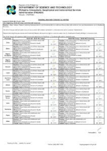
Mindanao Weather Breakdown
Davao Region
PAGASA identified the Davao Region as one of the most weather-affected areas in Mindanao on Sunday, forecasting cloudy skies with scattered rains and thunderstorms. The risk of flash floods and landslides from moderate to at times heavy rains has been explicitly flagged by the weather bureau. Upland communities and settlements along major river basins across Davao City, Davao del Norte, Davao del Sur, Davao Oriental, Davao Occidental, and Davao de Oro are placed on heightened alert status.
Caraga Region
Northeastern Mindanao’s Caraga region is similarly under threat, with cloudy skies and scattered rains and thunderstorms in the forecast. PAGASA warned that flash floods and landslides are a concern due to moderate to at times heavy rainfall across the region. The provinces of Agusan del Norte, Agusan del Sur, Surigao del Norte, Surigao del Sur, and Dinagat Islands — particularly communities situated in flood-prone valleys and along steep hillsides — are urged to remain on high alert throughout the day.
Western Mindanao and Palawan
The western sections of Mindanao, as well as Palawan, will experience partly cloudy to cloudy skies with isolated rainshowers or thunderstorms linked to the easterlies, according to PAGASA. Flash floods and landslides during heavy thunderstorm episodes remain a possibility in these areas as well, though the overall weather threat is less pronounced compared to the eastern portions of Mindanao.
Temperature and Humidity Readings
PAGASA’s Science Garden weather station in Diliman, Quezon City recorded data for the 24-hour period ending at 8:00 PM on June 12. The station logged a peak temperature of 32.9°C at 11:00 AM and a low of 26.0°C at 5:00 AM. Relative humidity over the same period swung between a high of 94 percent and a low of 62 percent, underscoring the humid and muggy conditions typical of the country’s wet season.
Wind Speed and Direction
Winds nationwide are expected to remain light to moderate for most of Sunday, PAGASA said. The northernmost areas of Luzon will see winds blowing from the south to southwest, while Palawan and the western sections of both Visayas and Mindanao will experience winds coming in from the southwest to south. The remainder of the country, including the eastern regions most affected by the weather system, will have winds from the southeast to south.
Sea Conditions and Wave Heights
Coastal waters around the archipelago are forecast to remain generally safe, with slight to moderate wave heights expected across most sea areas, according to PAGASA. Extreme Northern Luzon’s offshore waters may experience wave heights ranging from 0.6 to 1.5 meters. The coastal waters off Palawan, western Visayas, and western Mindanao, as well as the rest of the country, are expected to see wave heights of 0.6 to 1.2 meters. Fisherfolk and operators of small watercraft are advised to observe standard safety precautions given prevailing sea conditions.
Astronomical Data and Tidal Forecasts for Metro Manila
For Metro Manila on June 13, 2026, PAGASA reports that sunrise will occur at 5:27 AM, with sunset at 6:26 PM. The moon will rise at 3:07 AM and set at 4:30 PM, with a lunar illumination of only 4 percent, indicating the moon is approaching its new phase. According to tidal predictions from the National Mapping and Resource Information Authority (NAMRIA), Manila Bay will reach a high tide of 1.2 meters at 7:43 AM and a low tide of -0.05 meters at 4:01 PM.
Public Safety Advisory
PAGASA urged all residents — especially those in flood-prone and landslide-susceptible areas across the Davao Region, Caraga, Eastern Visayas, and Bicol — to remain vigilant, monitor updates from local government units, and avoid unnecessary travel to areas known to be at risk during periods of heavy rainfall. The public is encouraged to follow instructions from local disaster risk reduction and management offices should conditions deteriorate.
The weather agency will continue to issue updated forecasts as the situation develops throughout the day.
Originally reported by: PAGASA / wire reports