Residents across several provinces in Mindanao were jolted awake early Tuesday, July 28, 2026, when a tectonic earthquake measuring magnitude 5.1 struck near Baganga in Davao Oriental. The tremor was registered just after 7 AM and was perceptible across a broad swath of the island, though authorities say no damage is anticipated.
Earthquake Details
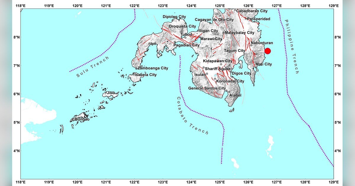
According to the Philippine Institute of Volcanology and Seismology (PHIVOLCS-DOST), the earthquake occurred at exactly 7:06:32 in the morning, Philippine Standard Time. The epicenter was pinpointed 15 kilometers south-southeast of Baganga, Davao Oriental, at geographic coordinates 7.51°N, 126.68°E. PHIVOLCS-DOST classified the event as tectonic in origin, with a magnitude of Mw 5.1 and a focal depth of 28 kilometers beneath the surface.
The agency released its official earthquake bulletin at 8:23 AM on the same day, providing the public with a detailed breakdown of felt intensities and instrumental readings across affected areas.
Affected Areas and Reported Intensities
The tremor registered varying degrees of shaking across a wide geographic area of Mindanao. Intensity levels are measured using the PHIVOLCS Earthquake Intensity Scale (PEIS), which ranges from barely perceptible movements to catastrophic ground motion. PHIVOLCS-DOST reported both public-submitted felt observations and instrument-recorded readings.
Intensity III — Noticeable Shaking
Intensity III on the PEIS describes shaking that is felt by many persons indoors, with hanging objects swinging visibly. Communities that reported this level of shaking include:
- Taragona, Davao Oriental
- Nabunturan, Davao de Oro
- City of Digos, Davao del Sur
- City of Bislig, Surigao del Sur
- Talacogon, Agusan del Sur
Intensity II — Slight Shaking
Intensity II shaking, described as felt by only a few people — especially those who are resting or in upper floors — was reported in several localities within Davao de Oro:
- Maco
- Compostela
- Montevista
- Mawab
Intensity I — Scarcely Felt
At the lower end of the felt scale, Intensity I — typically detectable only by instruments or by very few individuals under favorable conditions — was reported in the City of Tandag, Surigao del Sur.
Instrument-Recorded Intensities
Beyond the reports submitted by residents, PHIVOLCS-DOST’s network of seismic sensors captured the following instrumental intensity readings across a wider area of Mindanao:
- Intensity III (Instrumental): Nabunturan, Davao de Oro
- Intensity II (Instrumental): City of Digos, Davao del Sur
- Intensity I (Instrumental): City of Davao; Santa Maria, Davao Occidental; Matanao and Magsaysay, Davao del Sur; Malungon, Sarangani; Tupi, South Cotabato; San Fernando, Bukidnon; City of Kidapawan and Magpet, Cotabato
The instrumental data confirms that the effects of the quake extended well beyond Davao Oriental into neighboring provinces, reaching as far as Bukidnon and Cotabato.
Damage Assessment and Aftershock Warning
Despite the earthquake’s reach, PHIVOLCS-DOST has assessed that the event is not expected to produce structural damage in any of the affected communities. The magnitude, depth, and ground conditions all factor into this evaluation. However, the agency cautioned that aftershocks may still occur following the main event, and urged the public to remain alert and take precautionary measures.
PHIVOLCS-DOST advised the public to stay calm but prepared — securing heavy or fragile objects, identifying safe spots inside buildings, and being ready to evacuate if stronger subsequent tremors are felt.
Bulletin and Monitoring Protocol
In line with its standard operating procedure, PHIVOLCS-DOST indicated that this initial bulletin will be the only official release for this seismic event, unless new or updated information warrants a follow-up. An epicentral map was also included as part of the official bulletin documentation.
The public is encouraged to monitor updates directly through the PHIVOLCS-DOST official website at phivolcs.dost.gov.ph for the latest advisories and earthquake information.
By the Numbers
- Mw 5.1 — Magnitude of the earthquake as recorded by PHIVOLCS-DOST
- 28 kilometers — Depth of the earthquake’s focus below the surface
- 15 kilometers — Distance of the epicenter south-southeast of Baganga, Davao Oriental
- 7:06:32 AM PHT — Exact time the earthquake struck on July 28, 2026
- 8:23 AM PHT — Time PHIVOLCS-DOST released its official bulletin
- 5 provinces — Number of Mindanao provinces where felt shaking was reported
Why This Matters
A magnitude 5.1 earthquake is strong enough to be widely felt across a region, and the fact that it reached multiple provinces in Mindanao — including populated urban centers like Digos City and Bislig City — underscores the importance of active seismic monitoring in the area. While PHIVOLCS-DOST has assessed that no structural damage is anticipated from this particular event, the possibility of aftershocks means communities should remain vigilant. The earthquake serves as a reminder of Mindanao’s location within the seismically active Pacific Ring of Fire, where tectonic activity is a persistent reality for millions of Filipinos.
Source: PHIVOLCS-DOST Official Earthquake Bulletin, July 28, 2026
Related stories