QUEZON CITY, June 15, 2026 — The state weather bureau has placed the entire Philippine archipelago on alert for wet and potentially dangerous weather conditions on Monday, with the Philippine Atmospheric, Geophysical and Astronomical Services Administration (PAGASA) warning that a combination of easterly winds and localized thunderstorm development will bring rainshowers to every major island group — from the northernmost tip of Luzon down to the southernmost provinces of Mindanao.
PAGASA released its 24-hour public weather forecast at 4:00 AM on June 15, 2026, with the bulletin’s validity extending through 4:00 AM on June 16. The agency explicitly cautions all residents, regardless of region, to stay alert for the risk of flash floods and landslides in the event that any thunderstorm episode intensifies.
What Is Driving Monday’s Unsettled Weather
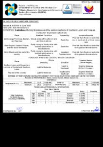
According to PAGASA, two main atmospheric factors are responsible for the widespread wet conditions on June 15. First, easterlies — prevailing winds blowing in from the eastern Pacific — are directly affecting the eastern portions of Visayas and Mindanao, generating cloudy skies and triggering isolated rain. Second, localized thunderstorm activity is responsible for the wet weather expected over Metro Manila and the rest of the country.
The agency confirmed that no tropical cyclone is currently active within or near the Philippine Area of Responsibility. The unsettled conditions are therefore entirely the product of seasonal atmospheric patterns typical of the Philippine wet season in June, where daytime heating combines with high humidity to generate afternoon thunderstorm clusters almost daily.
PAGASA described the general nationwide forecast as “partly cloudy to cloudy skies with isolated rainshowers or thunderstorms” — a characterization that applies broadly from northern Luzon to southern Mindanao. Despite the seemingly standard language, the bureau stresses that isolated thunderstorms during the wet season are capable of producing dangerous rainfall intensities within a very short span of time.
Luzon: Afternoon Downpours Expected in Metro Manila and Provinces
Residents and commuters in Metro Manila and across the wider Luzon region should prepare for partly cloudy to cloudy conditions on Monday, with isolated rainshowers or thunderstorms likely to develop, PAGASA said. The agency attributes these conditions to localized thunderstorm formation rather than any organized weather disturbance.
Weather patterns driven by daytime heating typically mean mornings will be relatively manageable, while the afternoon to early evening period carries the highest likelihood of heavy, short-duration downpours. Motorists navigating mountain roads in Benguet, Ifugao, and other highland provinces of Luzon should exercise particular caution during these peak thunderstorm hours, as sudden heavy rain can rapidly alter road surface conditions.
PAGASA forecasts winds over Luzon to blow from the southeast to southwest at light to moderate intensity throughout the day. Coastal and offshore waters adjacent to Luzon are expected to experience wave heights ranging from 0.6 to 1.8 meters, classified as slight to moderate — conditions that operators of small watercraft should factor carefully into any planned sea travel.
Visayas: Eastern Provinces Bear Brunt of Easterly Winds
Within the Visayas island group, Monday’s weather picture is shaped by two overlapping influences, according to PAGASA. Eastern Visayas — which includes Samar and Leyte — is under the more concentrated effect of the easterlies and can expect partly cloudy to cloudy skies with isolated rainshowers or thunderstorms directly tied to that wind pattern.
The remainder of the Visayas, spanning Western and Central Visayas provinces including Iloilo, Cebu, and Negros, falls under the nationwide localized thunderstorm pattern. PAGASA’s bulletin makes clear that the flash flood and landslide hazard applies uniformly across the entire region, not solely to those areas most directly influenced by the easterlies. Residents in river valley communities and hillside barangays throughout the Visayas are urged to remain on guard.
Wind direction over the Visayas mirrors that of Luzon, coming from the southeast to southwest at light to moderate speeds. Coastal waters surrounding the Visayas are forecast to have wave heights of 0.6 to 1.8 meters, a slight to moderate sea state.
Mindanao: Pacific-Facing Provinces Flagged as Priority Areas
PAGASA’s June 15 bulletin specifically identifies several Mindanao provinces as facing the direct impact of the easterlies: Dinagat Islands, Surigao del Norte, Surigao del Sur, and Davao Oriental. These areas face the Pacific Ocean without significant landmass buffer, making them the first territories to receive weather systems carried by easterly winds.
Local government units in these four provinces — many of which encompass communities built along river corridors and on sloping terrain — are advised to maintain heightened readiness for flash floods and landslides for the duration of Monday. According to PAGASA, the same partly cloudy to cloudy sky conditions with isolated rainshowers or thunderstorms apply here, with the added context of direct easterly influence.
Elsewhere across Mindanao, including major population centers such as Davao City, Cagayan de Oro, General Santos City, and Zamboanga City, the expected weather follows the national pattern of localized thunderstorm activity. PAGASA notes that winds over Mindanao will blow from the south to southeast — a slightly different orientation compared to the other island groups, reflecting the region’s proximity to the equatorial wind belt. Coastal waters around Mindanao are forecast at a somewhat calmer 0.6 to 1.2 meters in wave height.
Temperature, Humidity, and Why Storms Form in the Afternoon
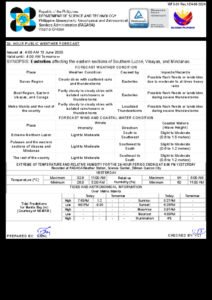
PAGASA’s weather station at Science Garden in Diliman, Quezon City recorded data for the 24-hour period ending at 8:00 PM on Sunday, June 14, giving a clearer picture of the atmospheric conditions feeding into Monday’s forecast. The highest temperature logged was 32.6°C at 5:00 PM, while the overnight low reached 24.5°C at 2:00 AM.
Relative humidity over the same period swung between a peak of 96% at 5:00 AM and a daytime low of 60% at 2:00 PM. These figures are significant: the combination of high surface temperatures and near-saturated humidity during the early morning hours creates precisely the kind of atmospheric instability that causes localized thunderstorms to build rapidly during the afternoon, particularly over urban heat islands such as Metro Manila. The agency notes that the “feels like” temperature during peak afternoon hours will likely be considerably higher than the actual thermometer reading.
Sunrise, Sunset, Moon Phase, and Tidal Data for June 15
For Metro Manila, PAGASA reports that the sun will rise at 5:27 AM and set at 6:26 PM on Monday, yielding roughly 13 hours of daylight. The moon rises at 5:09 AM and sets at 6:48 PM. Lunar illumination stands at 0%, indicating that June 15 falls on a new moon — a detail relevant for coastal communities navigating tidal behavior after dark.
Tidal data sourced from the National Mapping and Resource Information Authority (NAMRIA) shows a high tide of 1.47 meters for Manila Bay at 9:07 AM, with a low tide of -0.29 meters at 5:58 PM. Coastal barangays in Manila Bay and elsewhere should factor these tidal swings into flood-risk assessments, particularly if intense afternoon rain coincides with an incoming tide.
Key Safety Reminders for the Public
PAGASA’s bulletin explicitly flags flash floods and landslides as the primary hazards associated with Monday’s forecast — risks that extend nationwide, not just to the specific provinces named in the advisory. The following precautions apply across all regions:
Upland and mountainous communities should avoid unnecessary travel through ravines, riverbanks, and mountain passes whenever dark, towering clouds and thunder are present. Landslides triggered by intense but short-duration rainfall can occur with little warning.
Urban and flood-prone barangays — particularly those in Metro Manila known for rapid inundation — should closely monitor local drainage conditions and be prepared to move to elevated areas if floodwaters begin rising quickly following a downpour.
Coastal and maritime travelers should verify the latest PAGASA and Philippine Coast Guard advisories before departing, as wave conditions can deteriorate rapidly when thunderstorms pass over coastal waters. Small vessel operators are especially advised to exercise caution.
Residents may access updated weather bulletins at any time through the official PAGASA website or through local radio and television broadcasts, the agency reminded the public.
Originally reported by: PAGASA / wire reports