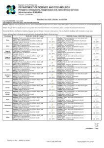
DUMAGUETE CITY, Negros Oriental — Thursday, July 3, 2026 will bring unsettled skies to Negros Oriental and much of the Visayas, with scattered downpours and lightning activity expected to interrupt what would otherwise be a partly cloudy day. The Philippine Atmospheric, Geophysical and Astronomical Services Administration (PAGASA) released its regional weather forecast at 5:00 AM, alerting residents in the province and neighboring areas to prepare for on-and-off rain throughout the day.
PAGASA’s bulletin covers Negros Oriental’s provincial capital, Dumaguete City, as well as interior and southern municipalities including Bayawan, Bais, and Guihulngan. The island province of Siquijor — visible from the Dumaguete waterfront — falls within the same forecast zone and faces identical conditions.
What PAGASA Is Forecasting
According to PAGASA, skies over the Visayas will be partly to at times fully cloudy throughout the day. While there will be brief dry spells, the agency warns that cloud cover can intensify rapidly, producing sudden and heavy downpours accompanied by thunder and lightning. The forecast is consistent with the kind of convective weather that is common across the central Philippines during the early weeks of July, when warm, moisture-heavy air periodically generates afternoon and evening thunderstorms.
PAGASA has not attributed Thursday’s weather to any specific named system — no tropical cyclone, low-pressure area, or named monsoon has been cited in the available forecast data as the driving force behind today’s conditions. The agency’s bulletin simply reflects a broad regional pattern of scattered thunderstorm activity typical of early July in the Visayas.
Temperatures, as reported by PAGASA, will remain within a warm and humid range — a low of 26°C overnight and a high of 32°C during the day. Winds will come from the northeast to east at light to moderate speeds. Coastal waters are rated slight to moderate, meaning conditions are manageable for larger vessels but potentially hazardous for smaller craft, particularly when a squall moves through.
By the Numbers
- Forecast temperature low: 26°C
- Forecast temperature high: 32°C
- Coastal wave heights (slight to moderate): roughly 0.5 to 2.5 metres
- Extended outlook covers through Saturday, July 5, 2026
- PAGASA extended outlook issued: 9:00 AM, July 2, 2026
- Primary forecast issued: 5:00 AM, July 3, 2026
Conditions for Sea Travel
PAGASA’s slight-to-moderate coastal water rating carries practical implications for the busy sea lanes around Negros Oriental. For large passenger ferries operated by companies such as OceanJet, SuperCat, and Lite Ferries on routes linking Dumaguete to Cebu and Siquijor, wave heights within this range are generally within normal operating parameters, the agency noted. However, PAGASA cautions that smaller outrigger boats and motorized pump boats — commonly used by fisherfolk and island-hopping tourists — face real danger at the upper end of this wave range, especially when gusty winds from a developing thunderstorm are added to the equation.
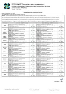
Cebu City and the Central Visayas corridor, which serve as key hubs for inter-island ferry traffic connecting to Dumaguete, will also experience partly cloudy to cloudy skies with rain and thunderstorms, according to PAGASA. Cargo operators and travelers using Visayas sea routes are advised to check the latest bulletins before departure. Small craft operators should consider waiting out any active storm before setting out, in keeping with PAGASA’s standard guidance for such conditions.
Advisories for Specific Groups
Fisherfolk and Coastal Communities
Fishermen operating out of Dumaguete port, the Malatapay fish landing in Zamboanguita, and coastal barangays in Bayawan and Bindoy are urged by forecasters to watch sea conditions closely before heading out. The slight-to-moderate coastal rating does not prohibit fishing, but the unpredictable nature of thunderstorm-driven squalls — which can produce strong gusts with minimal warning — demands heightened vigilance. PAGASA advises seafarers to watch for rapidly building cumulonimbus clouds, which grow tall and dark quickly in tropical conditions and are reliable indicators of approaching storms. Keeping trips short and staying near shore where possible is strongly recommended.
Commuters and Road Travelers
Motorists and commuters along the Negros Oriental coastal highway — whether traveling between Dumaguete and Bayawan, passing through Bais, or connecting at Guihulngan — should expect wet roads and reduced visibility during heavy rain episodes. Thunderstorm intensity typically peaks during the afternoon and early evening hours, PAGASA noted, so those with flexible schedules may wish to plan travel outside those windows. Anyone caught outdoors during lightning should seek solid shelter immediately, avoiding trees and metal-roofed structures.
Farmers and Agricultural Workers
Agricultural workers in Negros Oriental’s farming municipalities face interrupted fieldwork on Thursday. While seasonal rainfall generally benefits crops at this time of year, PAGASA’s forecast of lightning activity presents a serious hazard for workers in open fields, particularly those operating tractors or working near tall trees. Standard safety protocol requires moving to a solid, enclosed structure at the first sound of thunder and waiting at least 30 minutes after the final thunderclap before returning to work. Farmers who have recently harvested palay or corn and are currently sun-drying their produce should act now to cover or shelter their grain before afternoon showers arrive.
Students, Parents, and School Administrators
Parents sending children to school in Dumaguete, Siquijor, and across Negros Oriental are advised to pack rain gear and allow extra time for travel, particularly during dismissal hours. School administrators and local government units should monitor PAGASA’s updated forecasts throughout the day, as thunderstorm activity can intensify quickly and without extended warning. The current PAGASA bulletin carries no class suspension advisories, but conditions warrant continuous monitoring.
Outdoor Workers and Event Organizers
Construction crews, market vendors, and organizers of outdoor community or sports events should build contingency plans into their Thursday schedules. PAGASA’s “partly cloudy to at times cloudy” characterization means dry windows will exist, but these can be cut short by sudden, heavy showers. Having access to shelter at all times is essential for any outdoor activity today.
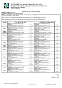
Extended Outlook: Friday Through Saturday
PAGASA’s extended weather outlook, which was issued at 9:00 AM on July 2, 2026, projects similar conditions through Saturday, July 5. Temperatures are expected to hold steady at a low of 26°C and a high of 32°C across all three days, and coastal waters are forecast to remain at slight to moderate throughout the period.
One notable development in the extended forecast, according to PAGASA, is a shift in wind direction. Thursday’s northeast-to-east winds are projected to transition to southwest-to-southeast by Friday, and then southwest-to-south by Saturday. The agency’s data suggests this directional change is worth monitoring because shifting winds across Visayas sea lanes can alter wave patterns and potentially affect ferry schedules even when wind speeds themselves remain light to moderate.
Residents and travelers with weekend plans — including excursions to Apo Island, Siquijor, or other popular destinations in the region — are encouraged to check PAGASA’s updated bulletins closer to their planned departure dates. Conditions may evolve, and the agency’s latest advisories will reflect any significant changes to the regional outlook.
Why This Matters
Negros Oriental’s communities depend heavily on sea travel, agriculture, and outdoor livelihoods, making accurate and timely weather forecasts from PAGASA a critical public safety resource. Thursday’s combination of thunderstorms and even moderate coastal wave conditions creates compounding risks for fisherfolk aboard small vessels, farm workers in open fields, and commuters on mountain and coastal roads. The three-day extended outlook through Saturday further underscores the need for continuous monitoring, as the forecast wind shift from northeast to southwest could affect conditions across vital inter-island sea routes throughout the weekend.
Source: PAGASA regional weather forecast, as published by breakingnewsnegrosoriental.com