DUMAGUETE CITY, Negros Oriental — July 4, 2026: A regional weather forecast released by the Philippine Atmospheric, Geophysical and Astronomical Services Administration (PAGASA) at 5:00 AM this Saturday places the entire Visayas region — including Negros Oriental and Siquijor — under an outlook of scattered rainshowers and thunderstorms for the day, urging residents, fisherfolk, commuters, and outdoor workers to take precautions before heading out.
From the port district of Dumaguete City to the southern coastal town of Bayawan, and from the northern cities of Bais and Guihulngan to the island province of Siquijor across the strait, overcast skies and periods of heavy rain are expected at various points throughout the day. Anyone with outdoor plans this weekend — whether work-related or recreational — should factor today’s unsettled weather into their schedules.
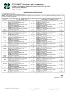
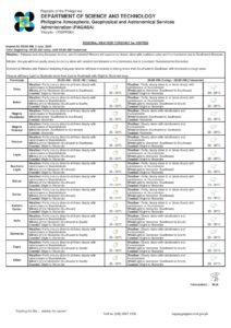
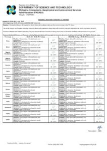
What PAGASA Is Forecasting Today
According to PAGASA’s 5:00 AM forecast bulletin for July 4, 2026, the Visayas region should expect partly cloudy to at times cloudy skies, with rainshowers or thunderstorms possible at any hour. The weather agency reported that winds are blowing from the northeast to northwest direction at light to moderate speeds. Coastal conditions have been classified as slight to moderate across Visayas waters, including the Tañon Strait and the sea lanes between Dumaguete and Siquijor.
PAGASA’s bulletin does not attribute today’s weather to a specific named system — no southwest monsoon, northeast monsoon, or low-pressure area has been cited as the primary driver. The agency noted that conditions are consistent with what is typically observed in the Visayas during the month of July, when abundant atmospheric moisture and warm sea surface temperatures make scattered thunderstorm development a routine occurrence.
The weather agency will issue updated bulletins as conditions evolve throughout the day.
Temperature, Wind, and Coastal Conditions at a Glance
The specific parameters detailed in PAGASA’s Visayas regional forecast for this Saturday are as follows:
- Sky condition: Partly cloudy to at times cloudy; rainshowers or thunderstorms expected
- Temperature: Low of 26°C, high of 32°C
- Wind speed: Light to moderate
- Wind direction: Northeast to Northwest
- Coastal condition: Slight to moderate
In practical terms, mornings may begin with some sunshine, but cloud build-up is expected as the day progresses. PAGASA noted that thunderstorm activity tends to peak in the afternoon during this kind of weather pattern, though evening storms cannot be ruled out.
By the Numbers
- 5:00 AM — Time the primary PAGASA forecast was issued on July 4, 2026
- 9:00 AM, July 3, 2026 — Time and date of PAGASA’s extended weekend outlook bulletin
- 26°C — Forecast low temperature for Negros Oriental and the Visayas
- 32°C — Forecast high temperature for Negros Oriental and the Visayas
- 30 minutes — Recommended wait time after thunder ceases before resuming outdoor work, per safety guidelines cited in the forecast advisory
Weekend Outlook: No Improvement Expected
PAGASA’s extended weather outlook, issued at 9:00 AM on Thursday, July 3, 2026, projects that weather conditions similar to those of Saturday will persist through Sunday. Both weekend days are expected to see temperatures between 26°C and 32°C, with light to moderate winds blowing from the northeast to east, and slight to moderate coastal conditions continuing across Visayas waters.
The weather agency’s bulletin offers no indication of a significant clearing trend before the weekend ends. Residents and workers planning outdoor activities for Sunday should maintain the same level of weather awareness they are advised to observe on Saturday.
Sea Travel Advisory
The “slight to moderate” coastal condition rating issued by PAGASA for Visayas waters this Saturday is significant for anyone planning to travel by sea. This classification indicates that wave heights are elevated enough to make sea travel uncomfortable and potentially hazardous for small, low-riding watercraft such as bangka outriggers and small fishing vessels.
Operators of small boats and outrigger bancas departing from coastal communities in Dumaguete, Bayawan, Bais, and other Negros Oriental port areas are advised to consult the latest marine bulletin before setting out. Passengers booked on inter-island ferry services — including routes between Dumaguete and Cebu or between Siquijor and Dumaguete — should confirm departure schedules directly with their shipping lines, as rough sea conditions could affect travel times.
Importantly, PAGASA’s forecast for this Saturday does not include any active gale warning, tropical cyclone wind signal, or rainfall advisory (yellow, orange, or red) for Negros Oriental or the broader Visayas region. The weather agency emphasized that today’s conditions are the result of ordinary thunderstorm activity, not a named storm — a distinction that calls for alertness, not alarm.
Sector-by-Sector Safety Reminders
Fisherfolk and Coastal Communities
For fishing communities along the coasts of Negros Oriental — including those in Bagacay, Tambobo, and the barangays of Bayawan and Bais — the combination of moderate swells and the possibility of sudden thunderstorms demands heightened caution at sea. PAGASA and maritime safety guidelines consistently advise mariners to return to port at the first sign of thunderstorm development on the horizon, without waiting for rain to begin. Lightning, sudden squalls, and rapidly building waves are among the most dangerous conditions small-boat operators can encounter.
Commuters and Inter-Island Passengers
Those commuting within Negros Oriental via motorcycle, tricycle, or public utility vehicles should bring rain gear and be prepared for sudden downpours. Low-lying streets and creek crossings in Dumaguete City and surrounding areas may be prone to flash flooding during intense thunderstorms. Passengers travelling by sea to Cebu, Siquijor, or other destinations are advised to contact their shipping line on the morning of departure and allow extra time for possible weather-related delays.
Farmers and Agricultural Workers
Farming communities in upland barangays such as those in Guihulngan, Vallehermoso, and Tayasan, as well as the lowland agricultural areas of Bais and Manjuyod, should expect intermittent rainfall throughout the day. While moderate rain is generally beneficial to crops during the growing season, PAGASA’s forecast of thunderstorms raises the possibility of intense, localized downpours that may cause soil erosion on sloped terrain or brief flooding in low-lying fields. Agricultural activities requiring dry conditions are better scheduled for the early morning hours.
Students, Parents, and School Activities
Parents sending children to school or extracurricular activities should ensure they are equipped with waterproof bags and rain gear. Any outdoor school events or sports activities planned for the weekend should have backup arrangements, given that PAGASA’s extended outlook shows no substantial weather improvement through Sunday.
Outdoor Workers and Construction Personnel
Workers engaged in construction, road projects, or other outdoor operations are advised to follow a clear lightning safety protocol. PAGASA-aligned safety guidelines specify that outdoor work should be suspended immediately upon hearing thunder or seeing lightning, with workers moving to an enclosed, sturdy structure. Work may resume only after at least 30 minutes have passed since the last thunder was heard.
No Storm Warning in Effect
As of the issuance of this report, PAGASA’s Visayas regional forecast carries no active tropical cyclone wind signals, gale warnings, or color-coded rainfall advisories for Negros Oriental or any other Visayas province. The weather agency clarified that the day’s unsettled conditions are driven by typical mid-year thunderstorm activity rather than a named or organized weather system. While residents are urged to remain cautious and weather-aware, there is no basis for heightened alarm at this time. PAGASA will continue to monitor atmospheric conditions and issue updated bulletins as necessary.
“Partly cloudy skies to at times cloudy with rainshowers or thunderstorm… Wind Speed: Light to Moderate, Direction: Northeast to Northwest, Coastal Condition: Slight to Moderate.”
Why This Matters
Weather forecasts of this nature carry direct, practical consequences for a province like Negros Oriental, where significant portions of the population depend on daily sea travel, coastal fishing, and rain-sensitive agricultural work. PAGASA’s advisory of slight to moderate coastal conditions affects the safety of fisherfolk and inter-island commuters on routes connecting Negros Oriental, Siquijor, and Cebu — any deterioration in sea conditions without advance awareness raises the risk of maritime incidents. The forecast also signals a continuation of unsettled weekend weather with no clearing in sight through Sunday, meaning residents, workers, and outdoor event organizers must plan around two full days of potential thunderstorm disruption rather than a single-day event.
Source: Breaking News Negros Oriental (breakingnewsnegrosoriental.com), based on PAGASA Visayas Regional Forecast issued July 4, 2026.