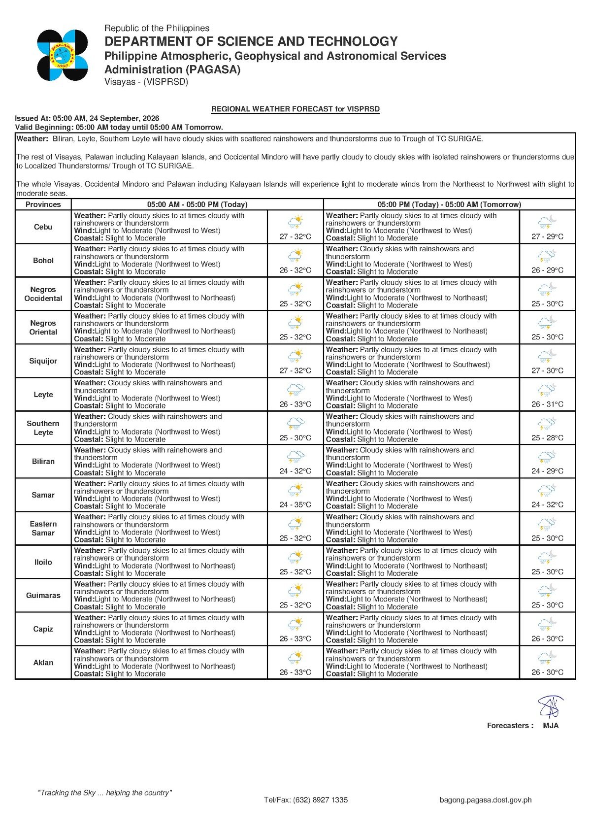
DUMAGUETE CITY, Negros Oriental — The Philippine Atmospheric, Geophysical and Astronomical Services Administration (PAGASA) has issued a regional weather forecast for Thursday, September 24, 2026, signaling a day of unsettled skies for communities across Negros Oriental, Siquijor, and the wider Visayas. Temperatures will hover between warm and humid levels, but the more pressing concern is the likelihood of sudden downpours and thunderstorms that could disrupt travel, fishing, farming, and daily commutes throughout the day.
Overview of Thursday’s Forecast
According to PAGASA’s bulletin released at 5:00 AM on September 24, 2026, sky conditions across the Visayas will be partly cloudy to at times cloudy, with rainshowers and thunderstorms likely at various points during the day. The agency’s forecast does not attribute these conditions to a specific named weather system — such as a tropical cyclone, monsoon surge, or low-pressure area. Instead, PAGASA describes a wind pattern blowing from the northwest to west at light to moderate speeds as the prevailing atmospheric feature.
This northwest-to-west wind orientation is consistent with late-September transitional weather in the Philippines — a period when the country’s atmosphere begins shifting between dominant weather regimes. PAGASA’s forecast data, as issued, points to moisture-laden winds driving cloudy spells and triggering convective showers: the kind that form quickly under daytime heat, deliver brief but intense rainfall and lightning, and then dissipate. This article does not speculate beyond what PAGASA has formally stated.
Temperature and Atmospheric Conditions
PAGASA projects a temperature range of 27°C on the low end and 32°C at the high end for the affected area on Thursday. While these figures are not extreme by Philippine standards, the combination of warmth, elevated humidity, and intermittent cloud cover will make the day feel heavy and uncomfortable — particularly during breaks between rain episodes when sun exposure intensifies.
The heat buildup during morning hours is also what fuels convective activity later in the day. Afternoon thunderstorms in the Visayas at this time of year typically develop between late morning and early evening, when surface heating is strongest. Residents across Negros Oriental — including those in Dumaguete City, Bais, Bayawan, Guihulngan, Tanjay, and La Libertad — are advised to be especially vigilant during this window.
By the Numbers
- Forecast bulletin issued: 5:00 AM, September 24, 2026
- Extended outlook issued: 9:00 AM, September 23, 2026
- Temperature low: 27°C
- Temperature high: 32°C
- Extended forecast high: 33°C (Wednesday and Thursday of the coming period)
- Moderate sea wave heights: up to approximately 2.5 meters
- Slight sea wave heights: approximately 0.5 to 1.25 meters
Coastal Waters: What “Slight to Moderate” Means in Practice
PAGASA classifies coastal sea conditions for Thursday as slight to moderate. The agency’s standard definitions place slight seas at wave heights of roughly 0.5 to 1.25 meters — generally navigable for larger ferries but already noticeable for small outrigger bancas. Moderate seas push wave heights toward 2.5 meters, a level that can make crossings genuinely hazardous for smaller watercraft and uncomfortable even for medium-sized vessels.
The sea state on any given day can fluctuate within this slight-to-moderate range depending on the exact location, the time of day, and whether a nearby thunderstorm intensifies local wind and chop. PAGASA’s advisory effectively means mariners and passengers cannot assume the calmer end of the range will hold throughout the day.
Those planning to travel on inter-island routes — including the Dumaguete–Siquijor, Dumaguete–Cebu, and other ferry corridors served by operators such as OceanJet and Montenegro Lines — should confirm sailing status directly with their carrier before proceeding to the pier. Ferry companies routinely adjust schedules or suspend operations when sea conditions deteriorate or when thunderstorms develop over crossing routes.
Guidance for Different Sectors
Fisherfolk and Small-Boat Operators
Fishermen taking bancas and small outrigger craft into the waters off Dumaguete, Bayawan, Bais, Tanjay, and around Siquijor face elevated risk on Thursday. PAGASA’s slight-to-moderate sea rating, layered on top of the threat of sudden thunderstorms, can create rapidly deteriorating conditions with very little warning. The agency’s bulletin strongly implies caution for small vessel operators: if dark clouds begin building, the prudent course is to return to shore immediately. A single day’s catch is not worth the hazard of being caught at sea in a thunderstorm.
Ferry Passengers and Inter-Island Travelers
Beyond fisherfolk, ordinary passengers crossing between islands should factor in the possibility of schedule disruptions. Even if a trip departs on time, conditions can worsen mid-crossing when a convective storm fires up. PAGASA’s forecast, as reported in the agency’s bulletin, recommends that travelers on smaller passenger vessels verify departure status before heading to the port and allow extra time for potential delays or reroutings.
Farmers and Agricultural Workers
For farming communities in the interior areas of Negros Oriental — including those cultivating sugarcane in the Guihulngan corridor, vegetables on the Canlaon foothills, and rice in the lowland municipalities — Thursday’s on-and-off showers present a mixed picture. Some rainfall may benefit crops, but sudden heavy downpours raise the risk of soil erosion on sloped terrain and can render farm roads impassable. PAGASA’s forecast suggests planning field tasks for the morning hours, before convective activity peaks, and ensuring harvested produce is moved under cover before afternoon showers develop.
Commuters, Motorists, and Motorcyclists
Drivers along the national highway network — connecting Dumaguete southward to Bayawan, and northward through Bais to Guihulngan — should anticipate slippery road surfaces and reduced visibility during rain events. Motorcyclists, who make up a significant portion of daily transport in Negros Oriental towns, are especially vulnerable during sudden showers. PAGASA’s broader weather advisory implies keeping rain gear accessible and pulling over to a safe location — away from trees — when lightning is present. Under no circumstances should anyone seek shelter under a tree during a thunderstorm, as tall trees are frequent lightning strike points.
Students, Parents, and Schools
With PAGASA warning of possible thunderstorms at any hour, parents preparing children for school on Thursday should include an umbrella or raincoat in their child’s bag. School officials and local government units are encouraged to monitor weather developments in the afternoon — the peak thunderstorm window — to plan dismissal procedures that keep students safe. According to PAGASA’s forecast, there is no guarantee of a clear afternoon, and the agency’s data suggests conditions can shift quickly.
Short-Term Outlook: No Dramatic Change Expected
PAGASA’s extended weather outlook, issued at 9:00 AM on September 23, 2026, projects that similar conditions will carry over into the following days. The agency’s forecast for Wednesday and Thursday of the coming period shows temperatures between 27°C and 33°C, with light to moderate northwest-to-west winds and slight to moderate coastal sea states remaining in place. This means neither a dramatic improvement nor a significant worsening is anticipated in the near term, based on the data PAGASA has publicly released.
Residents and local government officials in Negros Oriental, Siquijor, and across the broader Visayas region should continue monitoring PAGASA bulletins for any updates, particularly if a named weather system or new low-pressure area develops and begins to influence conditions over the coming days.
Why This Matters
PAGASA’s Thursday forecast carries practical consequences for a wide cross-section of Visayas communities — from fisherfolk and ferry passengers navigating slight-to-moderate coastal seas to farmers, commuters, and schoolchildren coping with sudden afternoon thunderstorms. The combination of warm, humid temperatures and moisture-laden northwest-to-west winds creates conditions where convective storms can develop and intensify rapidly, leaving little time for preparation if people are caught outdoors or at sea. With similar weather projected to persist through the coming days according to PAGASA’s extended outlook, communities across Negros Oriental and the broader region must remain alert and plan daily activities with the forecast in mind.
Source: PAGASA Regional Weather Forecast, breakingnewsnegrosoriental.com