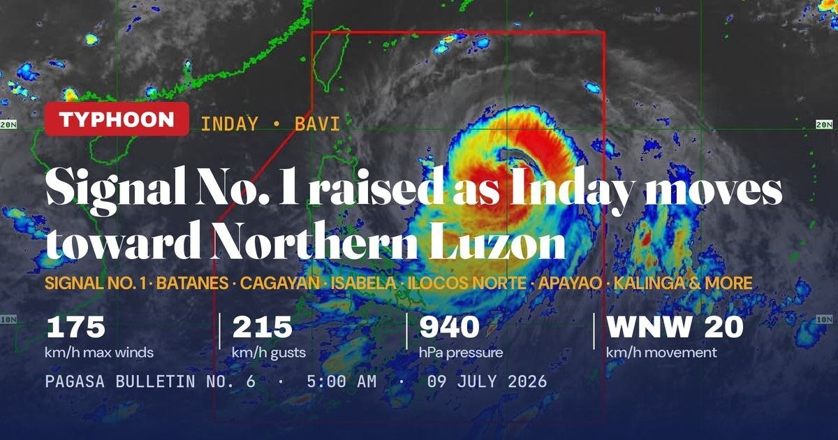
A powerful typhoon bearing down on the northern tip of the Philippines is now close enough to place several Luzon provinces under wind signal warnings, with the state weather service tracking its projected path toward Taiwan and mainland China over the coming days.
Typhoon Inday — carrying the international name Bavi — was still a formidable storm as of the early morning hours of Thursday, July 9, 2026, despite having shed some of its peak intensity. The Philippine Atmospheric, Geophysical and Astronomical Services Administration (PAGASA) placed it at 925 kilometers east of Northern Luzon as of 4:00 AM, with maximum sustained winds of 175 kilometers per hour and gusts reaching 215 km/h. Its central pressure stood at 940 hPa, PAGASA reported in its 5:00 AM bulletin.
The typhoon was moving west-northwestward at 20 km/h, PAGASA said, keeping it on a trajectory that forecasters expect will bring it to its closest point to Extreme Northern Luzon between the evening of Friday, July 10, and the early morning of Saturday, July 11.
Wind Signals Now in Effect Across Northern and Central Luzon
As Inday’s outer rain bands began influencing weather across the archipelago, PAGASA hoisted Tropical Cyclone Wind Signal (TCWS) No. 1 over a broad swath of northern and central Luzon. The provinces under Signal No. 1 include Batanes, Cagayan (encompassing the Babuyan Islands), Isabela, Apayao, Kalinga, and Ilocos Norte, along with portions of Quirino, Abra, Mountain Province, Ifugao, Aurora, and Catanduanes.
Under Signal No. 1 conditions, PAGASA said residents should expect strong winds of 39 to 61 km/h within the next 36 hours — a range that poses a minimal to minor threat to life and property. The weather bureau further noted that Signal No. 2 is the highest wind signal it expects to raise during Inday’s passage through the Philippine Area of Responsibility (PAR).
Projected Path: Taiwan and Eastern China After PAR Exit
After passing closest to Extreme Northern Luzon this weekend, Typhoon Inday is forecast to continue on a northwestward course toward the southern islands of Japan before potentially making landfall or skirting the northern coast of Taiwan. PAGASA said the typhoon is expected to exit PAR on Saturday, July 11, and to make landfall along the eastern coast of mainland China the following day, Sunday, July 12.
The weather bureau said Inday will undergo gradual weakening as it tracks away from the Philippine landmass, but it is not expected to drop below typhoon strength before leaving Philippine territory. Despite the slight decline in intensity observed in Thursday’s bulletin, PAGASA emphasized that the storm remains a powerful and well-organized system capable of causing serious damage near its path.
Southwest Monsoon Amplified by Typhoon’s Circulation
One of the wider concerns flagged by PAGASA is the intensification of the southwest monsoon — locally known as the habagat — by Inday’s expansive circulation. The weather bureau warned that the enhanced monsoon will drive strong to gale-force gusts across much of the country from Thursday through Saturday, July 11, affecting areas that are not directly in the typhoon’s forecast track.
PAGASA cautioned that heavy rainfall and damaging winds may be experienced in provinces far removed from the storm’s center, and it urged both residents and local disaster risk reduction and management offices nationwide to take all necessary precautionary measures. The agency’s warning underscores that the typhoon’s indirect effects can be just as hazardous as those near its core.
Gale Warning Issued; Batanes Faces Waves Up to Six Meters
Maritime conditions across several seaboards are already deteriorating. PAGASA issued a Gale Warning covering the northern and eastern seaboards of Luzon as well as the eastern seaboard of Visayas. The most extreme sea conditions are forecast along the Batanes seaboard, where wave heights could climb as high as 6.0 meters — conditions classified as extremely hazardous for all vessel types, the weather bureau said.
PAGASA explicitly advised mariners, particularly those operating small watercraft, to stay in port or proceed immediately to safe harbor. The agency said sea travel in all Gale Warning-affected areas carries significant risk for the duration of the warning period and should be avoided entirely until conditions improve.
Storm Structure Remains Compact Despite Slight Weakening
At 940 hPa, the central pressure of Typhoon Inday reflects a still-compact and organized storm structure, PAGASA said in its bulletin. That level of organization means the system retains the capacity to produce destructive wind and storm surge conditions in areas along or near its path. The 175 km/h sustained winds and 215 km/h gusts firmly keep Inday within the severe typhoon category by Philippine classification standards.
PAGASA said it will continue to issue updated bulletins as Inday progresses, and it reminded the public to monitor official advisories from the agency rather than rely on unverified social media reports during the typhoon’s approach.
By the Numbers
- 175 km/h — Maximum sustained winds of Typhoon Inday as of 4:00 AM, July 9, 2026
- 215 km/h — Peak gusts within the typhoon system
- 940 hPa — Central pressure of Typhoon Inday, indicating a compact storm structure
- 925 km — Distance of the typhoon’s center east of Northern Luzon at 4:00 AM
- 20 km/h — Westward-northwestward forward speed of the typhoon
- 39–61 km/h — Wind speed range expected in Signal No. 1 areas over the next 36 hours
- 6.0 meters — Forecast maximum wave height off the Batanes seaboard
- July 11 — Projected date of the typhoon’s exit from PAR
- July 12 — Forecast date of landfall along the eastern coast of mainland China
Why This Matters
Typhoon Inday represents the most consequential weather system to affect the Philippines this week, with TCWS No. 1 already active across multiple Luzon provinces and a Gale Warning in place along critical sea lanes. The amplified southwest monsoon means hazardous weather will extend far beyond the typhoon’s direct path, putting communities across the entire country at risk of heavy rainfall and dangerous wind conditions through the weekend. PAGASA’s explicit warnings to mariners and disaster response offices signal that preparations must be made at every level before Inday reaches its closest point to Philippine territory.
Source: PAGASA bulletin, July 9, 2026, as reported by breakingnewsnegrosoriental.com wire reports