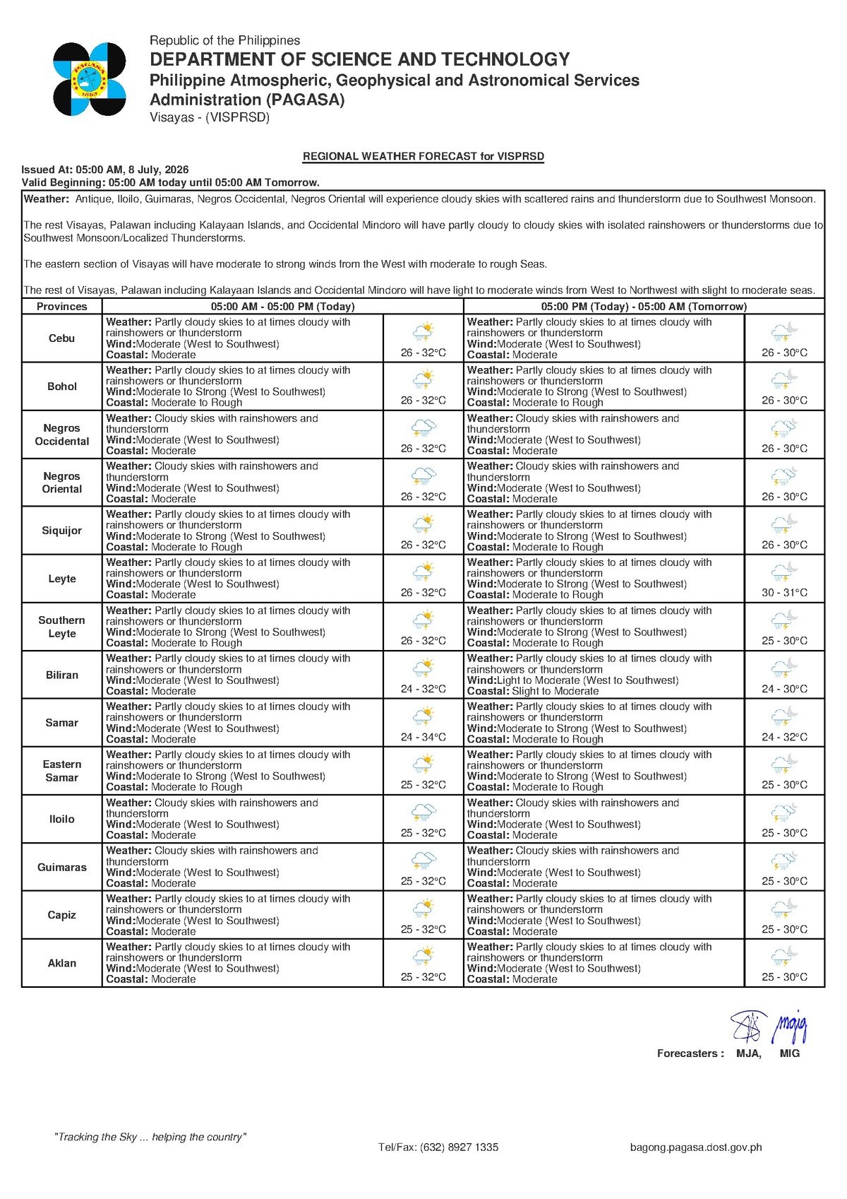
DUMAGUETE CITY — A monsoon-driven wet pattern will settle over Negros Oriental on Wednesday, July 8, 2026, with the Philippine Atmospheric, Geophysical and Astronomical Services Administration (PAGASA) warning that rainshowers and thunderstorms are possible throughout the day under partly cloudy to occasionally overcast skies. The forecast covers the broader Central Visayas region, including the island province of Siquijor and the province of Cebu.
PAGASA issued its regional outlook for the Visayas at 5:00 AM on July 8, projecting temperatures ranging from 26°C in the early morning to a midday peak of 32°C. Winds are blowing from the west to southwest at moderate speeds, and coastal waters across the area are currently classified as moderate.
The Force Behind the Wet Weather
The weather system responsible for today’s conditions is the habagat, or southwest monsoon — a large-scale seasonal wind pattern that draws warm, moisture-heavy air from the South China Sea and the Indian Ocean into the Philippine archipelago every year, generally between June and September. When the habagat is active over the Visayas, it sustains prolonged cloudiness, recurring showers, and periodic thunderstorms.
According to PAGASA’s extended weather outlook issued at 9:00 AM on July 7, 2026, southwest to westerly winds are expected to persist over the coming days. The agency noted that while no tropical cyclone wind signal is in effect for Negros Oriental, the sustained monsoon flow is strong enough to gradually roughen coastal seas and increase the likelihood of convective thunderstorm activity — especially during the warmer afternoon hours when daytime heating intensifies moisture in the lower atmosphere.
It is important to understand that the habagat is not a storm or typhoon. It is a persistent seasonal pattern, but one that can sustain multiple days of unsettled weather and progressively worsen sea conditions without a single named weather system being involved.
Local Conditions Across the Province and Visayas
For communities in Dumaguete City, Bayawan, Bais, Guihulngan, and the municipalities scattered along both the coastline and interior of Negros Oriental, today’s forecast translates into an on-and-off pattern of cloud cover and showers rather than relentless, continuous rainfall. Intense but brief downpours remain possible — particularly during the afternoon — as convective energy builds under the monsoon influence.
Siquijor, positioned in open water between Negros Oriental and Cebu, will experience comparable conditions: partly cloudy to overcast skies, intermittent rainshowers, and possible thunderstorms, with the same moderate wind and coastal water classification.
In Cebu and surrounding Central Visayas provinces, PAGASA projects a slightly cooler temperature band of 26°C to 30°C — a few degrees lower than the 26°C to 32°C range forecast for eastern Negros Oriental — under identical sky and wind conditions. The uniform nature of the forecast across the sub-region reflects how broadly the southwest monsoon is currently influencing Central Visayas weather.
By the Numbers
- 26°C — Forecast low temperature for Negros Oriental on July 8, 2026
- 32°C — Forecast high temperature for Negros Oriental on July 8, 2026
- 26°C to 30°C — Forecast temperature range for Cebu on the same day
- 26°C to 31°C — Forecast temperature range for Thursday, July 9
- 5:00 AM, July 8 — Time of PAGASA’s regional Visayas forecast issuance
- 9:00 AM, July 7 — Time of PAGASA’s extended weather outlook issuance
The Week Ahead: Conditions Deteriorate by Thursday
PAGASA’s multi-day extended outlook, released on July 7, 2026, outlines a progressively wetter and windier trajectory for the Visayas through the remainder of the week:
- Wednesday, July 8 (today): Moderate winds from the west to southwest; moderate coastal waters; temperatures of 26°C to 32°C.
- Thursday, July 9: Winds strengthen to moderate-to-strong, consistently from the southwest. Coastal waters deteriorate to moderate-to-rough. Temperatures expected between 26°C and 31°C.
- Friday, July 10: Partial outlook data available; temperatures starting at 26°C, with further details pending PAGASA’s latest updates.
The worsening conditions on Thursday represent the most significant shift in the near-term outlook. PAGASA’s forecast indicates that both wind speeds and wave heights will intensify, with direct implications for inter-island ferry services, fishing operations, and coastal communities across Negros Oriental and the wider Visayas.
Understanding the Forecast Terms
PAGASA’s current Visayas forecast carries no active tropical cyclone wind signal and no rainfall advisory specifically for Negros Oriental. The terminology used in the bulletin, however, carries practical meaning that residents should be aware of.
Moderate coastal conditions indicate wave heights at a level where small motorized outrigger boats (bangkas) can still operate, but with caution. Conditions can deteriorate rapidly when thunderstorms develop, and operators of non-motorized or very small craft are advised to remain close to shore.
Thunderstorm in a PAGASA bulletin means the possibility — not the certainty — of a storm event with lightning, gusty winds, and locally heavy rainfall. These typically form in the afternoon. Even a brief thunderstorm can trigger flash flooding in low-lying barangays and cause rivers and streams to rise quickly.
Moderate-to-rough coastal conditions, which PAGASA projects for Thursday, mean wave heights high enough to warrant caution even for larger motorized vessels. Small craft and non-motorized boats are strongly advised not to venture out under these conditions.
Practical Guidance for Key Sectors
Inter-Island Ferry Passengers
Travelers on routes between Dumaguete City and Siquijor, or on Dumaguete–Dapitan and Dumaguete–Cebu services, should find that today’s moderate coastal classification allows most fast-craft and ferry services to operate as scheduled. However, given that conditions are forecast to worsen on Thursday, passengers with flexible travel plans may want to complete inter-island trips today. PAGASA advises checking directly with ferry operators — including OceanJet, Lite Ferries, and Montenegro Lines — for real-time vessel status, as weather conditions can shift quickly when thunderstorms develop.
Fisherfolk and Coastal Boat Operators
Fishing communities in Dumaguete, Dauin, Siaton, Zamboanguita, and the coastal barangays of Bayawan and Bais face manageable but watchful conditions today. West-to-southwest moderate winds mean seas are workable, but the afternoon thunderstorm risk demands early departures and a return to port well before midday skies begin to darken. According to PAGASA’s extended outlook, Thursday’s stronger winds and rougher seas make it inadvisable for small-boat operators to set out at all on that day.
Farmers
Agricultural areas across Guihulngan, La Libertad, Vallehermoso, and inland Bayawan stand to benefit from today’s rain as supplemental irrigation — but face risks from sudden intense downpours associated with thunderstorms, which can cause soil erosion, flatten standing crops, and waterlog low-lying fields. Harvested produce left drying outdoors should be moved under shelter before noon. Workers in open fields should suspend outdoor activity during active thunderstorms due to lightning hazard.
Students, Parents, and School Administrators
PAGASA’s current forecast for Negros Oriental includes no storm signal or active evacuation advisory. Class suspensions are not automatically triggered by today’s conditions alone. That said, the agency’s bulletin underscores the unpredictability of afternoon thunderstorms — parents should equip children with rain gear, and administrators in flood-prone barangays are encouraged to monitor conditions during afternoon dismissal hours. If a thunderstorm develops during dismissal, the prudent course is to shelter in place and wait for the worst to pass before allowing students to move outdoors.
Why This Matters
The PAGASA forecast signals that the southwest monsoon is actively intensifying over the Visayas, with conditions expected to worsen measurably by Thursday — posing direct risks to maritime operations, coastal livelihoods, and low-lying communities across Negros Oriental and neighboring provinces. The combination of possible afternoon thunderstorms today and projected moderate-to-rough seas on July 9 means that fisherfolk, ferry passengers, and agricultural workers face a narrow window to act before conditions deteriorate further. Staying informed through PAGASA’s updated bulletins is essential for safety and operational planning throughout the remainder of the week.
Source: Breaking News Negros Oriental (breakingnewsnegrosoriental.com), based on PAGASA regional weather forecasts issued July 7–8, 2026.