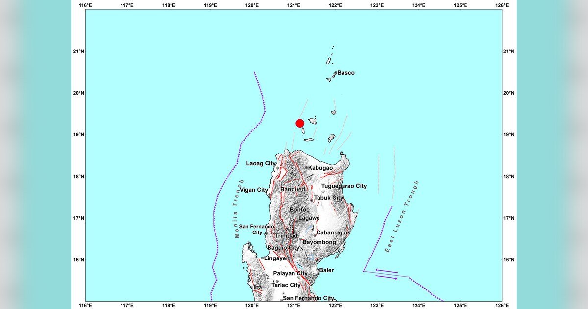
Philippine seismology authorities recorded a tectonic earthquake of magnitude 4.8 near Dalupiri Island in Cagayan on the afternoon of Wednesday, August 19, 2026 — an event that caused no felt shaking among residents and is not expected to produce aftershocks or structural damage, according to the Philippine Institute of Volcanology and Seismology (PHIVOLCS-DOST).
Location and Technical Details
PHIVOLCS-DOST reported that the earthquake struck at exactly 12:22:57 PM Philippine Standard Time (PHT). The epicenter was pinpointed 19 kilometers North 20° West of Dalupiri Island, also known as Calayan, within the province of Cagayan, at geographic coordinates 19.27°N latitude and 121.15°E longitude.
According to PHIVOLCS-DOST, the earthquake originated at a depth of 26 kilometers beneath the surface and was classified as tectonic in origin — meaning it was caused by the movement and interaction of tectonic plates rather than volcanic activity.
Intensity Readings at Monitoring Stations
The agency recorded instrumental shaking intensities at two monitoring stations within the region. Both stations registered Intensity I on the PHIVOLCS Earthquake Intensity Scale, which is the lowest possible classification on that measurement scale.
At Intensity I, ground motion is imperceptible to people going about their normal activities. PHIVOLCS explains that shaking at this level can only be detected by sensitive seismic instruments — not by human senses. The two stations that captured these readings were situated in Claveria, Cagayan, and Bacarra, Ilocos Norte.
No felt reports from members of the public were included in the PHIVOLCS bulletin for this event, which is consistent with the Intensity I readings recorded by instruments.
Assessment: No Damage, No Aftershocks
PHIVOLCS-DOST assessed that the earthquake is not expected to produce any damage to structures or infrastructure. The agency likewise stated that no aftershocks are anticipated following this seismic event — an assessment it included directly in the official bulletin released to the public.
This classification places the August 19 earthquake among relatively routine low-intensity seismic events in Philippine territory, where tectonic activity is common given the country’s position along the Pacific Ring of Fire.
Bulletin Release and Monitoring Advice
PHIVOLCS-DOST issued its official bulletin — designated as Earthquake Information No. 2 — at 12:57 PM PHT on August 19, 2026, which was approximately 34 minutes after the earthquake was recorded. An epicentral map was made available alongside the bulletin for reference.
The agency indicated that this bulletin will serve as the only official release for this particular event, unless new or additional information becomes available that warrants a follow-up notice. PHIVOLCS-DOST advises the public to always refer to the latest earthquake information posted on the agency’s official website at phivolcs.dost.gov.ph for accurate and timely updates.
By the Numbers
- Magnitude: 4.8 (tectonic)
- Time of occurrence: 12:22:57 PM PHT, August 19, 2026
- Epicenter distance: 19 kilometers North 20° West of Dalupiri Island (Calayan), Cagayan
- Coordinates: 19.27°N, 121.15°E
- Focal depth: 26 kilometers
- Instrumental intensity recorded: Intensity I at 2 monitoring stations (Claveria, Cagayan and Bacarra, Ilocos Norte)
- Bulletin issued: 12:57 PM PHT — approximately 34 minutes after the quake
Why This Matters
While this particular earthquake posed no threat to lives or property, its documentation by PHIVOLCS-DOST is part of the continuous seismic monitoring that keeps Philippine communities informed about ground activity across the archipelago. The Philippines sits along the Pacific Ring of Fire, making it one of the most seismically active countries in the world, and even low-magnitude events contribute to the scientific record used in hazard assessment. Timely bulletins such as this one help local government units and residents make informed decisions and reduce unnecessary alarm during seismic events.
Source: PHIVOLCS-DOST / wire reports