DUMAGUETE CITY, Negros Oriental — November 6, 2026: From the northern towns of Dumaguete and Bais down to Bayawan in the south — and across the sea to Siquijor — no part of Negros Oriental is expected to escape unsettled weather on Friday. The Philippine Atmospheric, Geophysical and Astronomical Services Administration (PAGASA) has placed the entire province under a forecast of partly cloudy to occasionally cloudy skies with rainshowers or thunderstorms, a pattern that persists through the night and into early Saturday morning.
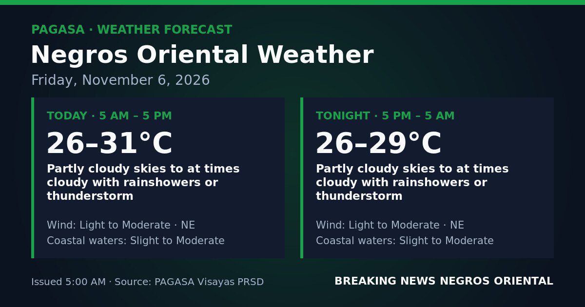
PAGASA released the forecast at 5:00 AM on Friday, November 6, 2026. It covers a continuous 24-hour window running from 5 AM Friday to 5 AM Saturday, meaning the threat of showers and thunderstorms remains active well after sunset.
Weather Driver
PAGASA’s forecast does not name a specific weather system — such as the northeast monsoon, a low-pressure area, or the Inter-Tropical Convergence Zone — as the cause of Friday’s conditions over Negros Oriental. What the agency has stated is that sufficient cloud build-up and atmospheric moisture exist to produce rainshowers and thunderstorms at any point during the 24-hour period. Winds are described as light to moderate, blowing from the northeast, consistent with the province’s northeastern exposure within the Visayas region.
Detailed Forecast for Negros Oriental
5 AM to 5 PM (Daytime)
Skies will be partly cloudy to at times cloudy, with rainshowers or thunderstorms possible at various hours. According to PAGASA, daytime temperatures will range from a low of 26°C to a high of 31°C. Winds will blow from the northeast at light to moderate strength. Coastal waters off Dumaguete, through the Tañon Strait between Negros and Cebu, toward Siquijor, and along the Bayawan coastline will be slight to moderate.
5 PM to 5 AM Saturday (Overnight)
Conditions after dark offer little improvement. PAGASA indicates that skies will remain partly cloudy to at times cloudy overnight, with rainshowers or thunderstorms still possible. Temperatures will range from 26°C to 29°C. Northeast winds stay light to moderate, and coastal waters remain slight to moderate. Those with early Saturday sea travel should factor this overnight forecast into their departure decisions.
Understanding the Forecast Terms
“Partly cloudy to at times cloudy with rainshowers or thunderstorms” does not mean continuous rain. There will be breaks of partial sunshine, but rain can develop and arrive at unpredictable times throughout the day or night. Thunderstorms specifically carry the risk of sudden heavy downpours, lightning, and brief gusts — typically without extended warning, and most likely to form during the afternoon when daytime heat builds up.
“Light to moderate” northeast winds are generally manageable on land, but on open water — particularly during a thunderstorm — gusts can momentarily spike well above prevailing wind speed, creating hazardous conditions for small vessels.
“Slight to moderate” coastal waters follow PAGASA’s official sea-state classification. Slight seas are passable for larger inter-island ferries but uncomfortable for small outrigger bancas. Moderate seas present genuine risk for small-boat operations, especially when thunderstorm gusts hit simultaneously. The forecast indicates waters may be at either end of this range at different times. PAGASA has issued no active tropical cyclone wind signals and no gale warning for Negros Oriental waters as of the time of issuance.
Guidance by Sector
Ferry Passengers and Inter-Island Travelers
Passengers on routes linking Dumaguete to Cebu, Siquijor, Bohol, and other Visayas ports — including those booked with OceanJet, Montenegro Lines, and other carriers — should confirm departure statuses directly with their operators before proceeding to the port. Although no gale warning is in effect, slight-to-moderate seas combined with thunderstorm risk can cause scheduling disruptions, particularly for smaller fast-craft vessels on the Dumaguete–Siquijor and Dumaguete–Cebu corridors. Allow additional time and check with your operator.
Fisherfolk and Small-Boat Operators
Given PAGASA’s slight-to-moderate sea-state rating and the persistent thunderstorm threat across both daytime and overnight periods, small banca and outrigger operators are advised to exercise caution throughout Friday and into Saturday morning. Thunderstorm development can quickly roughen seas and produce sudden gusts dangerous to small vessels far from shore. Those who must go out are encouraged to stay close to the coast and return to port at the first sign of dark cloud build-up on the horizon. Night fishing on open water carries the same risk and requires heightened vigilance.
Farmers
Agricultural areas in Guihulngan, Bais, Manjuyod, and the highland barangays along the Cuernos de Negros range should expect variable conditions throughout the day. Fieldwork requiring extended dry spells — including fertiliser or pesticide application, harvesting, and crop drying — may be interrupted by sudden rain at any hour. Early morning hours, when skies are more likely to be partly cloudy, offer the better window for outdoor farm tasks. Drying crops should be secured before midday, when thunderstorm development becomes increasingly likely.
Students, Parents, and School Administrators
PAGASA’s forecast for Friday does not carry weather warnings of a level that typically triggers automatic class suspensions. However, parents of students in low-lying or flood-prone barangays — particularly near river systems in Dumaguete, Bayawan, and surrounding municipalities — should monitor conditions during the afternoon when thunderstorms are most probable. Maintain open communication with school administrations and ensure children have an umbrella or rain gear for travel to and from school.
Outdoor Workers and Event Organisers
Construction crews, infrastructure workers, and public service personnel working outdoors in Dumaguete or elsewhere in Negros Oriental on Friday should include rain contingency plans in their schedules. The thunderstorm risk extends through the overnight hours, which also affects evening outdoor events. Lightning poses a genuine hazard during thunderstorms; individuals should seek solid shelter at the first sound of thunder and wait until the storm has fully passed before resuming outdoor activity.
Siquijor Island
According to PAGASA’s forecast, the same general conditions — partly cloudy to at times cloudy skies, rainshowers or thunderstorms possible, light to moderate northeast winds, and slight to moderate coastal waters — will also affect sea lanes between Negros Oriental and Siquijor. Travellers heading to or from the island should anticipate possible disruptions and confirm conditions with their vessel operators before departure.
Source: PAGASA