Monday, September 7, 2026, opens under the broad influence of the Southwest Monsoon, with the Philippine Atmospheric, Geophysical and Astronomical Services Administration (PAGASA) warning that large portions of Luzon and the Visayas could see anything from scattered showers to occasional heavy downpours throughout the day — and that coastal waters in both island groups are expected to turn moderate to rough.
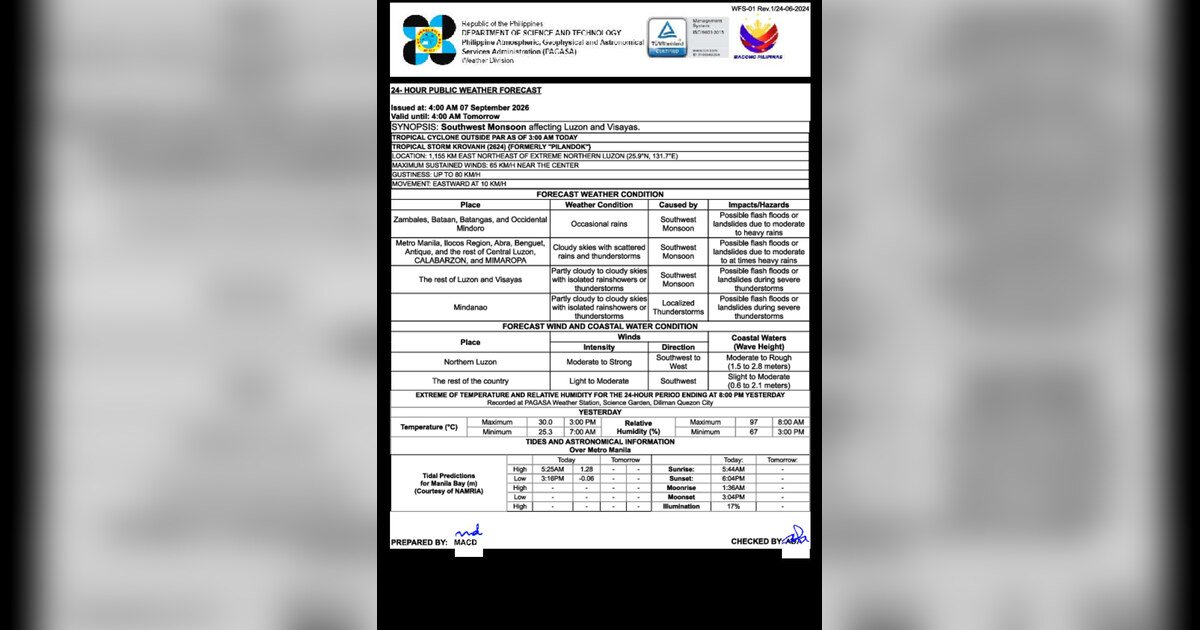
PAGASA released its 24-hour public weather bulletin as of 5:00 AM on Monday, noting that a tropical cyclone located outside the Philippine Area of Responsibility (PAR) is compounding the monsoon’s effects on the country’s weather systems. While the cyclone remains beyond PAR, its interaction with the Southwest Monsoon is intensifying rainfall and wind conditions across several regions.
Areas Under the Monsoon’s Direct Influence
According to PAGASA’s official weather bulletin, the Northeast portion of the country is bearing the strongest direct effects of the Southwest Monsoon. However, the agency stressed that conditions are far from uniform, with risk levels and precipitation amounts varying considerably from one region to the next.
The hardest-hit provinces in the forecast are Zambales, Bataan, Batangas, and Occidental Mindoro, which are expected to receive occasional to heavy rain under Southwest winds. PAGASA specifically identified these areas as at risk for flooding and landslides during the forecast period.
A broader swath of areas — including Metro Manila, the Ilocos Region, Abra, Benguet, Antique, Aklan, Capiz, Iloilo, CALABARZON, and MIMAROPA — is expected to see mostly cloudy skies with scattered to isolated rain showers, also under Southwest winds. PAGASA cautioned that flash floods or landslides remain possible in these localities.
For the rest of Luzon and the Visayas, isolated rain showers or thunderstorms are forecast, with flash floods or landslides a possibility specifically during episodes of severe thunderstorms. In Mindanao, winds are tracking from the Southeast rather than the Southwest, though isolated rain showers or thunderstorms are similarly expected, and flash floods or landslides could occur during thunderstorms.
Maritime and Coastal Water Advisories
Mariners, fisherfolk, and other sea travelers should exercise particular caution on Monday, as PAGASA has flagged elevated sea state conditions for most of the country’s major maritime zones.
Luzon seas are forecast to have moderate to rough coastal waters driven by Southwest winds at moderate to strong intensity. The Visayas sea areas face a similar outlook, with moderate to rough coastal waters also under Southwest winds. Elsewhere in the country, slight to moderate sea conditions are expected, with Southwest winds of up to moderate strength. The weather agency’s advisory effectively discourages unnecessary sea travel in the more affected zones.
Metro Manila Temperature and Humidity Readings
Based on data from the PAGASA Weather Station located at Science Garden in Diliman, Quezon City, temperature extremes recorded the previous day showed a high of 30.0°C at 3:00 PM and a low of 25.3°C at 7:00 AM. Relative humidity hit its peak of 97 percent at 8:00 AM before easing somewhat by mid-afternoon — a pattern consistent with monsoon-season mornings when moisture-laden air keeps humidity levels elevated well into the day.
Tidal Information and Astronomical Data
PAGASA, drawing on tidal data sourced from the National Mapping and Resource Information Authority (NAMRIA), reported that Metro Manila’s high tide is expected to occur at 5:24 AM on Monday. Sunrise over Metro Manila is set for 5:44 AM, with sunset to follow later in the evening. Coastal communities, particularly those in low-lying areas, are advised to be mindful of the high tide timing in combination with the rain-driven runoff that the monsoon may bring.
By the Numbers
- 30.0°C — peak temperature logged the previous day at 3:00 PM (PAGASA Science Garden station, Diliman)
- 25.3°C — overnight low temperature recorded at 7:00 AM the previous day
- 97% — highest relative humidity reading, recorded at 8:00 AM the previous day
- 5:24 AM — projected high tide time for Metro Manila on Monday
- 5:44 AM — scheduled sunrise time for Metro Manila on Monday
Why This Matters
A Southwest Monsoon reinforced by an external tropical cyclone creates compounded hazard conditions — heavier rainfall totals, stronger winds, and elevated seas that together raise the danger of flooding, landslides, and maritime accidents well above what either weather system would produce alone. PAGASA’s bulletin covers an extensive geographic area spanning multiple provinces in Luzon and the Visayas, meaning a large share of the country’s population could be exposed to these risks simultaneously. Residents in flood- and landslide-prone barangays, as well as those who rely on coastal or offshore livelihoods, are urged by the weather agency to monitor updates closely and act on official advisories without delay.
Source: PAGASA / DOST official weather bulletin, September 7, 2026