DUMAGUETE CITY, Negros Oriental — October 22, 2026: The Philippine Atmospheric, Geophysical and Astronomical Services Administration (PAGASA) has issued a weather forecast placing Negros Oriental under a full day of rainshowers and thunderstorms, sustained southwesterly winds, and unsettled coastal waters — conditions that will affect ferry travelers, fisherfolk, farmers, students, and outdoor workers across the province from Thursday morning through early Friday.
The Weather Driver: Southwest Monsoon
PAGASA’s data identifies the southwest monsoon — known locally as habagat — as the system behind Thursday’s weather. The monsoon draws warm, moisture-laden air from the direction of the South China Sea and Sulu Sea across the archipelago. As this airflow meets the terrain of the Visayas, it is pushed upward, cools rapidly, and generates the persistent cloud cover, rainshowers, and thunderstorms affecting the province. The agency notes that moderate to strong winds and an elevated sea state are direct consequences of this sustained monsoon pattern.
Hour-by-Hour Forecast for Negros Oriental
Daytime Period: 5:00 AM to 5:00 PM
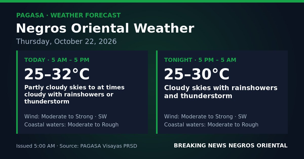
According to PAGASA’s 5:00 AM bulletin, skies over Negros Oriental will be partly cloudy to at times cloudy during daylight hours, with rainshowers or thunderstorms possible at any point. Breaks in cloud cover are expected, but the agency cautions that thunderstorms can develop quickly under these conditions. Daytime temperatures will range between 25°C and 32°C. Winds are classified as moderate to strong, blowing from the southwest, with coastal waters rated moderate to rough.
Overnight Period: 5:00 PM to 5:00 AM (Friday)
PAGASA’s overnight forecast shows a deterioration in conditions after dusk. The bulletin describes cloudy skies with rainshowers and thunderstorms — a shift from the daytime’s “at times cloudy” language to simply “cloudy,” indicating a more continuous and less intermittent rain pattern through the night. Overnight temperatures will fall within a range of 25°C to 30°C. Southwesterly winds remain moderate to strong, and coastal waters stay in the moderate to rough range through the overnight hours.
Understanding the Forecast Terms
Moderate to Strong Winds
Within PAGASA’s wind classification scale, moderate winds are already clearly perceptible — strong enough to sway small tree branches and make walking into the wind uncomfortable. Strong winds represent a step up, capable of making outdoor activity difficult, posing hazards to light structures, and significantly affecting the handling of small watercraft. PAGASA’s bulletin holds this wind range across the full 24-hour period, with no forecast lull expected either during the day or overnight.
Moderate to Rough Coastal Waters
PAGASA’s sea-state classification progresses from calm through smooth, slight, moderate, rough, and beyond. Moderate seas already present genuine difficulty for small bancas and fishing boats. Rough seas carry hazard even for larger inter-island vessels, with wave heights that can complicate deck operations on ferries and pose a direct capsize risk to smaller craft. Thursday’s forecast spans the moderate-to-rough range, meaning sea conditions may shift within that band throughout the day and night.
Thunderstorms
PAGASA’s forecast includes thunderstorms in both the daytime and overnight windows. The agency notes that a thunderstorm is not simply heavy rainfall — it brings lightning, which is an immediate danger to anyone in open areas, on water, or working in fields; sudden strong gusts; intense downpours over short periods; and the potential for flash flooding in low-lying and flood-prone areas. The overnight thunderstorm forecast is of particular note for those outdoors, traveling, or at sea after dark.
Sector-by-Sector Guidance
Ferry Passengers and Inter-Island Travelers
Dumaguete port serves as the primary inter-island gateway to Cebu, Siquijor, Dapitan, and other destinations via OceanJet and other ferry operators. With PAGASA rating coastal waters as moderate to rough and maintaining that classification overnight, trip cancellations, delays, or rerouting remain a real possibility throughout Thursday. The agency advises passengers to contact their ferry operator directly before heading to the port and not to assume a scheduled departure will proceed on time. Those facing overnight crossings will encounter the more severe combination of rough seas and simultaneous thunderstorms.
Fisherfolk and Small-Boat Operators
PAGASA’s moderate-to-rough coastal water forecast covers the waters surrounding Negros Oriental, including the Visayan Sea and the Tañon Strait. Fisherfolk in Bayawan, Bais, Tanjay, and communities along the northern coast toward Guihulngan face a high-caution day, the agency indicates. Small bancas and fishing boats are advised to remain in port. Those already at sea should monitor conditions and return to shore well ahead of the overnight period, when strong winds, rough seas, and the possibility of sudden thunderstorm gusts will combine to create serious risk for small watercraft.
Farmers
Agricultural communities in the interior of Negros Oriental — including farming areas in Guihulngan, La Libertad, Zamboanguita, and the upland barangays of Bayawan — face a day of persistent rain and thunderstorms, according to the PAGASA bulletin. Primary concerns include standing water in low-lying fields, soil erosion on slopes, and the lightning hazard for anyone working in open fields. Farmers are advised to complete urgent fieldwork during early morning breaks in cloud cover and to seek enclosed shelter before any thunderstorm develops. Shelter under tall trees during lightning is unsafe.
Students, Parents, and School Administrators
With PAGASA forecasting rainshowers and thunderstorms from early morning, parents are advised to equip children with appropriate rain gear. School administrators in flood-prone areas should monitor local government advisories, as intense rainfall bursts from thunderstorms can cause rapid localised flooding near drainage channels and low-lying school grounds. PAGASA’s forecast does not itself trigger automatic class suspension — that authority rests with local government units — but the potentially intense and intermittent nature of Thursday’s thunderstorms warrants close monitoring throughout the day.
Outdoor Workers and Commuters
Construction workers, utility crews, market vendors, and others working outdoors across Dumaguete City and the wider province should keep rain gear on hand at all times, as PAGASA notes that thunderstorms can develop with little warning even during partly cloudy intervals. Motorcycle riders and passengers on open-air vehicles should prepare for sudden heavy downpours and reduced visibility. The agency advises that anyone caught outside during a thunderstorm should move immediately to a sturdy, enclosed structure away from windows and open areas.
Source: Breaking News Negros Oriental (breakingnewsnegrosoriental.com), citing PAGASA weather bulletins.