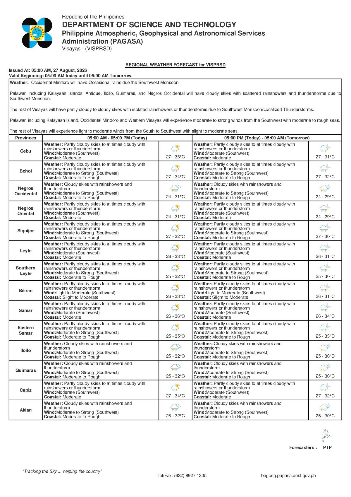
DUMAGUETE CITY — The southwest monsoon is making its presence felt across Negros Oriental and the broader Visayas on Thursday, August 27, 2026, bringing with it a day of unsettled weather that includes scattered rainshowers, periods of cloudiness, and thunderstorms. The state weather agency, PAGASA, released its regional forecast for the Visayas at 5:00 AM Thursday, flagging communities from Dumaguete to Siquijor — and across the wider Visayas — for wet and potentially stormy conditions throughout the day.
The Weather Driver: What Is Habagat?
The primary force shaping Thursday’s conditions is the habagat, or southwest monsoon — a seasonal wind system that draws warm, moisture-heavy air from the southwest across the Philippine archipelago. According to PAGASA, this pattern typically dominates from June through September each year. When the moist air carried by the habagat rises over land and warm coastal waters, it condenses into cloud formations that produce rainshowers and, frequently, afternoon thunderstorms. While the habagat is a routine feature of the Philippine wet season, it is capable of generating intense, localised downpours and can raise sea conditions enough to affect inter-island ferry operations and small watercraft.
PAGASA’s extended outlook, issued at 9:00 AM on Wednesday, August 26, noted that southwest winds are forecast to intensify from moderate to moderate-to-strong by Friday, August 29. This suggests that conditions across Negros Oriental and the Visayas may become more difficult as the week closes out.
Thursday’s Forecast Across Negros Oriental and the Visayas
For August 27, PAGASA’s 5:00 AM bulletin describes the sky condition as partly cloudy to at times cloudy, with scattered rainshowers and thunderstorms expected throughout the day for the Visayas region. This forecast covers all major areas of Negros Oriental — including Dumaguete City, Bayawan City, Bais City, and Guihulngan City — as well as the island province of Siquijor and surrounding Visayas provinces such as Cebu.
Temperature-wise, PAGASA forecasts a low of 27°C and a high of 33°C for Thursday. Mornings will feel warm and humid, while the afternoon heat is expected to feel more oppressive ahead of incoming rain. Southwest winds are classified as moderate — meaning wind speeds are perceptible but generally not disruptive on land. At sea, however, those same winds translate into moderate coastal conditions, which carry practical consequences for boat travel and fishing operations along Negros Oriental’s coastlines and inter-island routes.
The weather bureau’s extended outlook also indicates that temperatures will remain at 27°C (low) and rise to 34°C (high) on the extended forecast days of Wednesday and Thursday, with winds holding steady from the southwest at moderate strength. By Friday, August 29, PAGASA projects a wind speed increase to moderate-to-strong from the southwest, with coastal conditions escalating to moderate-to-rough — a notable development for anyone planning sea travel into the weekend.
By the Numbers
- 27°C — Forecast low temperature for Thursday, August 27, 2026
- 33°C — Forecast high temperature for Thursday, August 27, 2026
- 34°C — Forecast high temperature in the extended outlook period
- 5:00 AM — Time of PAGASA’s Thursday Visayas regional forecast bulletin
- 9:00 AM, August 26 — Time of PAGASA’s extended weather outlook issuance
- Friday, August 29 — Date when winds are projected to escalate to moderate-to-strong
Understanding “Moderate Coastal Conditions”
PAGASA classifies Thursday’s coastal conditions as moderate. In practical terms, this means wave heights are elevated to a level that makes small boat operations uncomfortable and potentially hazardous — particularly for bancas, outrigger fishing vessels, and other small watercraft without enclosed hulls. Passengers aboard larger inter-island commercial ferries may experience noticeable movement and rolling, though scheduled commercial vessels are generally designed to operate under moderate sea conditions.
As of the 5:00 AM Thursday bulletin, PAGASA had not raised a gale warning for the region, meaning wind speeds at sea had not yet crossed the threshold that would require small craft to remain in port. That said, the weather bureau’s moderate coastal condition classification is still a caution-level advisory — one that operators of small vessels should take seriously. Conditions can shift rapidly when afternoon thunderstorms develop, producing sudden wind gusts not captured in morning forecasts.
“Partly cloudy skies to at times cloudy with rainshowers or thunderstorm.” — PAGASA Visayas Regional Forecast, 5:00 AM, August 27, 2026
Guidance for Different Sectors
Commuters and Land Travellers
Rain-soaked roads, reduced visibility, and potential flooding in low-lying barangays are all possibilities during heavy spells or thunderstorm episodes on Thursday. Commuters and motorists are advised to bring rain gear and allow extra travel time, particularly during peak afternoon hours when thunderstorm activity typically intensifies. Drivers along coastal highways should be alert to reduced visibility caused by sea spray under moderate wind conditions.
Fisherfolk and Small-Boat Operators
The waters around Negros Oriental — including the Tañon Strait and the sea approaches to Siquijor — are under moderate coastal conditions Thursday. PAGASA’s data makes clear that small banca and outrigger operators should stay close to shore and continuously monitor developing weather. The appearance of towering, dark cumulonimbus clouds is a warning sign of imminent thunderstorm activity; vessels should return to port immediately upon sighting such formations. Given Friday’s projected deterioration to moderate-to-rough seas, overnight fishing runs during this period should be avoided or carefully planned.
Ferry Passengers on Dumaguete Routes
Those travelling on inter-island routes departing from Dumaguete Port — including crossings to Siquijor, Cebu, and other destinations served by operators such as OceanJet and Montenegro Lines — should verify schedules with their respective ferry companies ahead of travel. Moderate sea conditions may produce choppy crossings Thursday, and the outlook turning moderate-to-rough by Friday means weekend travellers should monitor PAGASA updates closely and opt for flexible booking arrangements where available.
Farmers and Agricultural Workers
The combination of habagat moisture, warm temperatures, and intermittent heavy showers presents mixed conditions for farming communities across Negros Oriental. Farmers in areas such as Guihulngan and Bayawan are advised to watch soil saturation in low-lying fields, where waterlogging risks damage to root crops and vegetables. Morning windows — typically drier before afternoon convective activity builds — are the best periods for harvesting or field applications that cannot be carried out in wet conditions.
Schools and Outdoor Activities
No tropical cyclone wind signal has been raised for the region, according to PAGASA, but thunderstorms remain a real and fast-moving hazard. Schools scheduling outdoor events or flag ceremonies should have contingency plans in place. The standard safety guideline applies: at the first sound of thunder or sight of lightning, move everyone indoors immediately and wait at least 30 minutes after the last observed lightning strike before resuming any outdoor activity.
Construction and Outdoor Workers
Outdoor workers across Negros Oriental — including those on construction sites and road maintenance crews — should expect weather-related disruptions during afternoon thunderstorm periods. Lightning poses a direct and serious risk to workers at elevation or in open areas. Site supervisors are urged to establish clear weather-watch protocols and identify designated safe shelter areas near all active work sites before the day begins.
The Week Ahead: Extended Outlook Summary
PAGASA’s extended weather outlook, released at 9:00 AM on August 26, 2026, paints a picture of gradually worsening conditions moving into the weekend. While Thursday’s winds remain moderate from the southwest, Friday, August 29 is expected to see an escalation to moderate-to-strong winds, with coastal conditions shifting from moderate to moderate-to-rough. Residents and travellers planning activities near the coast or at sea should factor this progression into their decisions over the coming days and monitor PAGASA’s twice-daily bulletins for the latest updates.
Why This Matters
The southwest monsoon is a recurring seasonal system, but its day-to-day intensity directly affects the safety of thousands of fisherfolk, commuters, ferry passengers, and agricultural workers across Negros Oriental and the Visayas. Thursday’s combination of moderate coastal conditions and afternoon thunderstorm risk creates real hazards for small watercraft operations and outdoor activities — particularly given that conditions are forecast to deteriorate further into rough seas by Friday. Timely awareness of PAGASA’s forecasts allows communities to take concrete protective steps that reduce risk to lives and livelihoods.
Source: Breaking News Negros Oriental (breakingnewsnegrosoriental.com)