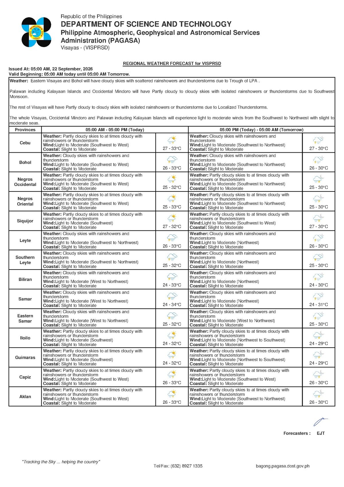
Dumaguete City, Negros Oriental — September 22, 2026: The southwest monsoon is asserting itself once more over the Visayas, with the Philippine Atmospheric, Geophysical and Astronomical Services Administration (PAGASA) issuing a forecast of rainshowers and thunderstorms for the region throughout Tuesday. Communities from Dumaguete to Guihulngan, and across the waters to Siquijor, can expect unsettled skies, choppy coastal conditions, and the kind of unpredictable, fast-moving storm activity typical of late-season habagat weather.
PAGASA released its Visayas regional weather forecast at 5:00 AM on September 22, 2026, supplemented by an extended outlook issued at 9:00 AM the previous day, September 21, 2026. Together, these bulletins paint a consistent picture of wet and breezy conditions persisting through the early part of the coming week.
Daytime and Overnight Conditions
Tuesday’s daytime hours will bring partly cloudy to at times cloudy skies, with rainshowers and thunderstorms possible at any point, according to PAGASA. The temperature range for the day spans from a low of 27°C to a high of 33°C. While that upper figure signals genuine heat during any brief dry spells, the combination of high humidity and frequent cloud cover will keep conditions feeling sticky and oppressive for outdoor workers, students, and commuters alike.
The overnight picture, as described in PAGASA’s forecast, is arguably less comfortable than the daytime. Cloud cover is expected to thicken into Tuesday evening, with the agency describing cloudy skies with rainshowers and thunderstorms continuing through the night. Overnight temperatures are forecast to hold between 27°C and 30°C — offering little relief from the day’s warmth. This nocturnal rainfall pattern is a familiar characteristic of southwest monsoon conditions, where moist air continues to destabilize and produce convective activity well past sunset.
The Weather Driver: Late-Season Habagat
PAGASA’s forecast attributes today’s conditions to winds blowing from the southwest to west across the Visayas region — the unmistakable signature of the habagat, or southwest monsoon. This seasonal wind system draws warm, moisture-saturated air from the South China Sea and the Philippine Sea across the archipelago, typically from June through September. As that moist air mass encounters the elevated terrain of Negros, Cebu, and neighboring islands, it is forced upward, cools rapidly, and releases its moisture in the form of the rainshowers and thunderstorms now being forecast.
Late September occupies a transitional window in the Philippine weather calendar. PAGASA has noted that this period marks the gradual retreat of the habagat and the early stirrings of the northeast monsoon, or amihan. That shift between dominant wind regimes tends to produce exactly the kind of variable, unsettled weather the agency is describing for today — conditions that can fluctuate quickly and catch residents off guard.
Coastal Waters and Sea Conditions
Across the Visayas, PAGASA describes coastal waters as slight to moderate for Tuesday. In practical terms, this means wave heights ranging from roughly 0.5 to 1.25 meters on the lower end, climbing toward 1.25 to 2.5 meters in moderate conditions. For major fast-craft operators such as OceanJet and SuperCat, these sea states fall within normal operating parameters, though passengers on routes like Dumaguete–Cebu or Dumaguete–Siquijor may experience noticeable rocking. For smaller wooden fishing vessels and outrigger bangka, however, moderate wave conditions present a genuine hazard — especially if a thunderstorm develops suddenly and produces gusting winds above the baseline forecast.
PAGASA’s data confirms that no gale warning is currently in effect for Negros Oriental or the broader Visayas, and no tropical cyclone warning signals are active as of the time of the forecast. The disruption being forecast is the product of prevailing monsoon winds, not an acute storm system. That said, the agency’s own forecast acknowledges that thunderstorms can generate sudden, localized wind gusts that exceed what a general forecast can accurately capture — making situational awareness on the water especially important today.
Provincial Breakdown: What to Expect Across Negros Oriental
Fisherfolk and Coastal Communities
Small boat operators and fisherfolk working out of coastal barangays in Dumaguete, Dauin, Zamboanguita, Bayawan, and other shoreline communities along the province should treat today with extra caution. While PAGASA has not issued a gale warning, the agency’s forecast makes clear that thunderstorms are possible throughout the day and into the night. Thunderstorms can produce rapid wind speed increases with little advance notice. Operators of small outriggers are advised to keep fishing runs closer to shore than usual, maintain constant visual monitoring of cloud formations to the west and northwest, and return to port promptly at any sign of darkening skies — rather than waiting for rain to begin.
Inter-Island Ferry Passengers
Travelers using sea routes connecting Dumaguete to Cebu, or Siquijor to Dumaguete, should anticipate a somewhat rougher crossing than usual during moderate wave periods. According to PAGASA, no widespread service disruptions are indicated by current conditions, but localized thunderstorms can temporarily worsen sea states and prompt ferry operators to delay or adjust departures. Passengers, particularly those booked on early morning or late afternoon crossings when convective storm activity tends to peak, are advised to confirm schedules directly with their ferry operators before heading to the terminal.
Farmers and Agricultural Workers
Agricultural communities across Negros Oriental — including sugarcane growers in the lowlands around Bais and Guihulngan, and vegetable farmers in upland areas — face a mixed forecast. The expected rainfall may reduce the need for supplemental irrigation, providing some benefit during a period when soil moisture can fluctuate. However, PAGASA’s forecast also includes the risk of gusty winds accompanying thunderstorms, which can damage standing crops, flatten sugarcane, and disturb nursery seedlings. Farmers are advised to secure loose materials and postpone any scheduled pesticide or fertiliser application, as wet and windy conditions reduce efficacy and increase the risk of chemical drift.
Students, Parents, and School Administrators
With afternoon thunderstorms in the forecast, families in Negros Oriental should ensure children are equipped with raincoats or umbrellas before heading to school on Tuesday. PAGASA’s forecast indicates the possibility of heavy, localized downpours during the afternoon hours — precisely when most students are dismissing and commuting home. School administrators are encouraged to monitor conditions from midday onward and prepare contingency plans for outdoor events, physical education classes, and after-school activities, which may need to be relocated indoors or rescheduled.
Outdoor and Construction Workers
Those engaged in outdoor labour — including road construction crews, building site workers, and infrastructure project teams across the province — should front-load heavy or precision-dependent tasks to the morning hours, before convective activity is likely to intensify. PAGASA’s forecast of afternoon and evening thunderstorms means that working conditions during the second half of the day could deteriorate quickly. Site supervisors should have rain protocols in place and ensure that workers have safe shelter readily accessible.
By the Numbers
- 5:00 AM, September 22, 2026 — Time PAGASA released its Visayas regional forecast
- 9:00 AM, September 21, 2026 — Time PAGASA released its extended weather outlook
- 27°C – 33°C — Daytime temperature range for Negros Oriental on Tuesday
- 27°C – 30°C — Overnight temperature range for Tuesday evening into Wednesday
- 0.5 – 2.5 meters — Wave height range under “slight to moderate” coastal conditions as defined by PAGASA
Why This Matters
PAGASA’s forecast of sustained rainshowers and thunderstorms across Negros Oriental on September 22 poses practical risks for a broad cross-section of the province’s population — from fisherfolk navigating slight-to-moderate coastal seas without gale warning coverage, to farmers contending with potential crop damage from gusty convective winds. The absence of a formal gale warning does not eliminate hazard; PAGASA itself acknowledges that localised thunderstorms can produce sudden wind gusts beyond what general forecasts reflect. For a province with extensive coastlines, active fishing communities, agricultural lowlands, and regular inter-island ferry traffic, a day-long threat of scattered thunderstorms demands preparedness across multiple sectors simultaneously.
Source: PAGASA / breakingnewsnegrosoriental.com