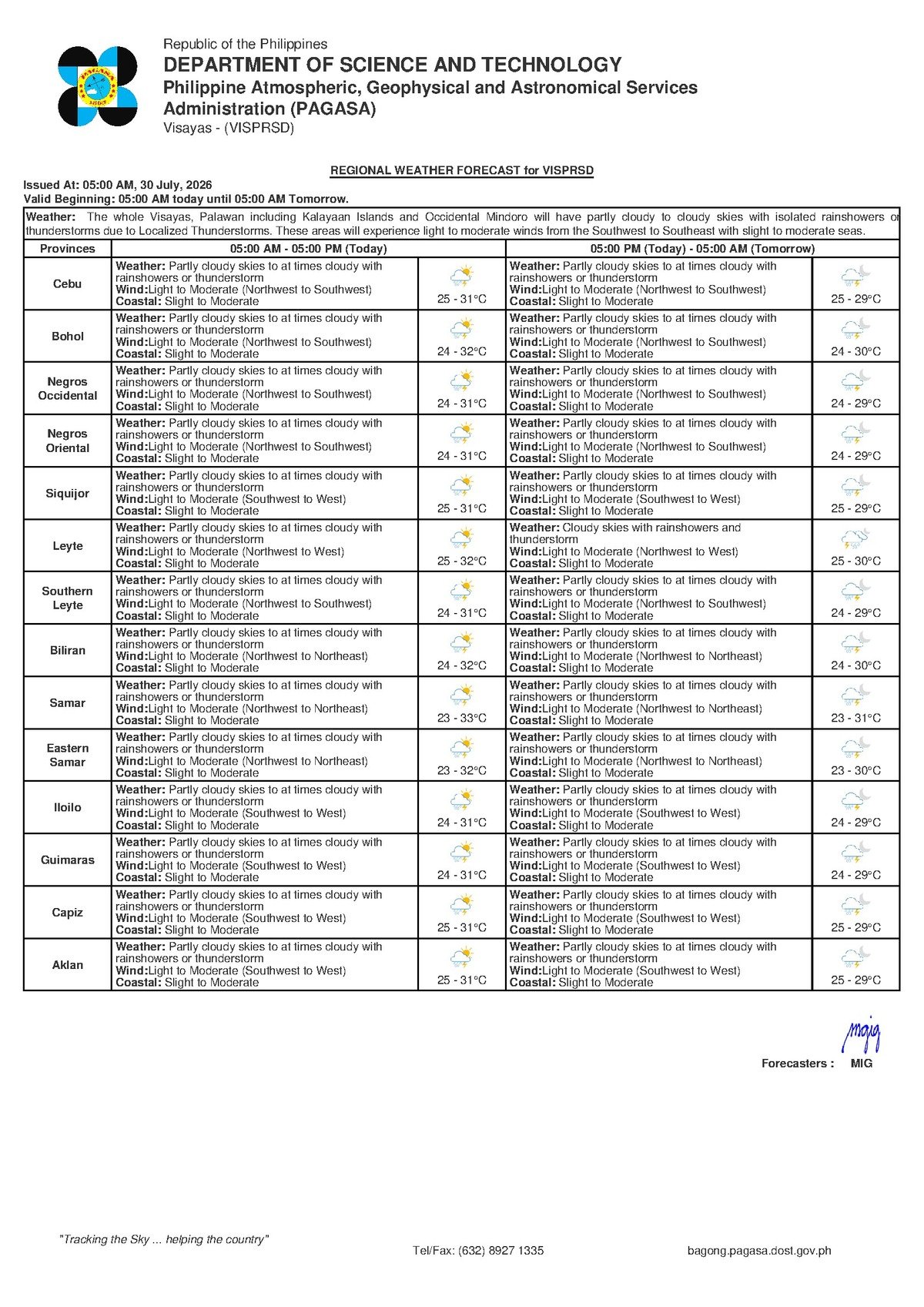
Wet and unsettled weather is on the way for communities across Negros Oriental and the broader Visayas region this Thursday, July 30, 2026, after the Philippine Atmospheric, Geophysical and Astronomical Services Administration (PAGASA) released its early-morning regional forecast warning of rainshowers and thunderstorms that could develop at any point during the day.
PAGASA issued the Visayas Regional Forecast at 5:00 AM on July 30, 2026, covering all provinces and cities within the region. The bulletin directly applies to communities throughout Negros Oriental — including Dumaguete City, Bayawan City, Bais City, Guihulngan City, and the island province of Siquijor — giving residents, commuters, fisherfolk, and outdoor workers advance notice to prepare for rapidly changing conditions.
What Is Driving the Unsettled Conditions
According to PAGASA, prevailing winds are blowing from the northwest to southwest direction across the Visayas on Thursday. While the agency’s bulletin for this period does not attribute the weather to a named tropical system, PAGASA confirmed that the wind flow is drawing warm, moisture-laden air across the region. As this air rises over land and sea, it cools and condenses, producing the cloud build-ups that trigger rainshowers and thunderstorms.
Weather patterns of this kind are characteristic of late July in the Philippines, when the southwest monsoon — locally known as the habagat — remains active and atmospheric instability is common even in the absence of a named storm. PAGASA’s forecast makes clear that while rain will not necessarily fall continuously, conditions throughout the day will be favorable for sudden and at times intense thunderstorm development.
Forecast Details: What to Expect on July 30
The PAGASA bulletin outlines the following conditions for Negros Oriental and the Visayas on Thursday:
Sky and precipitation: Partly cloudy to at times cloudy skies, with rainshowers or thunderstorms likely to develop through the course of the day. Residents should not interpret the partly cloudy periods as an all-clear — conditions can shift from calm to stormy within minutes when convective thunderstorms are in the forecast.
Temperature range: PAGASA projects an overnight low of 25°C and a daytime high of 31°C. While passing showers will bring brief relief from the heat, the high humidity during breaks between rain events is expected to make conditions feel muggy, particularly in coastal low-lying areas such as Dumaguete and Bais City.
Wind conditions: Winds are described as light to moderate, blowing from the northwest to southwest. These speeds are sufficient to cause noticeable tree movement and create choppy surface conditions at sea, but PAGASA has not issued gale warnings based on wind speed alone.
Coastal sea state: The agency rates coastal waters as slight to moderate — a classification that signals wave activity sufficient to affect small watercraft and make crossings uncomfortable or potentially hazardous for very small vessels.
By the Numbers
- Forecast issued: 5:00 AM, July 30, 2026
- Overnight low temperature: 25°C
- Daytime high temperature: 31°C
- Coastal sea state: Slight to moderate
- Extended outlook reference: issued 9:00 AM, July 29, 2026
Sea Travel: What “Slight to Moderate” Means for Passengers and Mariners
PAGASA’s coastal sea-state classification of “slight to moderate” reflects a sea surface with active wave movement — not entirely calm, but within the operating range of larger commercial vessels. Passengers aboard major ferry lines such as OceanJet or Cokaliong on routes connecting Dumaguete to Cebu, Bohol, or Siquijor can generally expect travel to proceed, though those susceptible to motion sickness should prepare accordingly.
However, the Philippine Coast Guard and ferry operators may impose restrictions or outright bans on smaller outrigger boats and motorized pump boats — locally called bancas — operating on inter-island or coastal routes. Small-boat operators running services to Apo Island, Siquijor’s coastal barangays, or across the Tañon Strait should exercise heightened caution and monitor for any deterioration in conditions if a thunderstorm cell approaches.
PAGASA advises that squalls associated with thunderstorms can produce brief but sharp wind gusts and sudden wave height increases well beyond the baseline forecast levels. Anyone already at sea who observes dark, anvil-shaped cloud formations building nearby should return to port without delay. Lightning remains a serious and direct hazard for individuals aboard open watercraft.
Guidance for Fisherfolk in Coastal Municipalities
Fisherfolk based in Negros Oriental’s coastal communities — including Sibulan, Dauin, Zamboanguita, and Santa Catalina — are urged to take the thunderstorm component of today’s forecast seriously. PAGASA’s marine safety guidance is consistent on this point: small watercraft should not venture far from shore when thunderstorms are possible. The combination of light-to-moderate baseline winds and the elevated risk of sudden squalls creates conditions where staying close to port is the prudent choice.
Those who do put out to sea should maintain a close watch on developing cloud formations and be ready to head back at the first signs of a building storm system. Listening to PAGASA radio updates or monitoring official weather advisories before and during any sea voyage is strongly recommended.
Advice for Farmers in Negros Oriental’s Agricultural Areas
For farmers working in Negros Oriental’s interior and upland municipalities — including sugarcane-producing areas around Guihulngan, Vallehermoso, and La Libertad — Thursday’s forecast presents a mixed situation. Moderate rainfall during the growing season is generally beneficial, but the sudden, heavy downpours that accompany thunderstorm activity can cause localised flooding on low-lying farm plots, damage young or maturing crops, and cut off access to fields.
Agricultural workers are advised to prioritise any time-sensitive tasks, such as pending harvests, during morning hours before afternoon convective activity intensifies. During active thunderstorm periods, PAGASA’s guidance is straightforward: avoid open fields, secure harvested produce and equipment from rain damage, and seek sturdy shelter until the storm fully passes.
Commuters, Students, and Residents: Day-to-Day Precautions
In Dumaguete City and surrounding municipalities — including Bacong, Valencia, and Sibulan — residents should expect the possibility of rainshowers at any hour on Thursday. Morning skies may appear partly clear, but the forecast does not guarantee a dry start to the day. Students, parents, and daily commuters should carry rain gear as a matter of routine today.
Motorists travelling along the national coastal highway of Negros Oriental, as well as those on mountain roads toward Valencia and interior barangays, should reduce speed during rain episodes and maintain greater following distances. Heavy rain can reduce road visibility significantly and leave road surfaces slippery, particularly on curves and hillside sections prone to runoff.
Outdoor workers in construction and road maintenance, as well as organisers of fiestas, school programmes, or sports events scheduled for Thursday, should have contingency plans in place. PAGASA’s forecast does not indicate all-day continuous rain, but thunderstorms can develop without significant advance warning, disrupting outdoor activities and posing lightning safety risks to anyone in the open.
Why This Matters
PAGASA’s July 30 forecast of rainshowers and thunderstorms across the Visayas carries direct safety implications for the many residents of Negros Oriental who depend on maritime travel, coastal fishing, and outdoor agricultural work for their daily livelihoods. Thunderstorm-generated squalls can rapidly exceed baseline sea-state and wind forecasts, posing life-safety risks to small-boat operators and fisherfolk who may be caught off guard. Timely awareness of the agency’s guidance — especially the slight-to-moderate coastal sea rating and the lightning hazard associated with active thunderstorm cells — allows communities to make informed decisions that reduce exposure to weather-related harm.
Source: PAGASA Visayas Regional Forecast, July 30, 2026 / breakingnewsnegrosoriental.com