QUEZON CITY, June 16, 2026 — The Philippine Atmospheric, Geophysical and Astronomical Services Administration (PAGASA) has placed the entire country on alert for scattered thunderstorms on Tuesday, cautioning that severe weather episodes could trigger flash floods and landslides in vulnerable communities. The warning was contained in the agency’s 24-hour public weather forecast released at 4:00 AM.
No typhoon or low-pressure area is currently active within or near the Philippine area of responsibility, PAGASA confirmed. Weather conditions on Tuesday are instead being shaped by two separate atmospheric drivers: easterly winds pushing warm, moisture-heavy air into the eastern sections of Visayas and Mindanao, and localized convective activity responsible for thunderstorms elsewhere across the archipelago. PAGASA noted this pattern is characteristic of the transitional period between the dry season and the southwest monsoon.
Although no catastrophic weather event is anticipated, PAGASA’s explicit hazard advisory means residents living near rivers, in low-lying coastal areas, or on hillsides and mountain slopes should remain vigilant and stay tuned to updates from local disaster risk reduction offices.
General Weather Picture
Broadly speaking, the Philippines will see a mix of partly cloudy to overcast skies throughout Tuesday, with rain showers and thunderstorms possible at various times of day, according to PAGASA’s forecast bulletin. The principal distinction from one area to the next is not the type of weather expected, but its cause.
The eastern flanks of Visayas and Mindanao are being directly fed by the easterlies — warm, Pacific-originating air currents — while thunderstorm development across Luzon and the rest of the Visayas and Mindanao will largely be driven by surface heating. As temperatures climb through the morning and midday hours, accumulated heat and humidity are released in the form of afternoon or evening downpours. Outdoor events, road travel, and commutes — especially in cities prone to street flooding — may be affected.
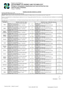
Luzon Weather Conditions
Metro Manila and all of Luzon’s provinces can expect partly cloudy to overcast skies punctuated by isolated rain showers or thunderstorms on Tuesday, the state weather bureau said. The primary cause of rainfall over Luzon is localized convection rather than a large-scale weather system.
PAGASA said residents of Metro Manila, CALABARZON, Central Luzon, the Ilocos Region, Cagayan Valley, the Cordillera Administrative Region, MIMAROPA, and the Bicol Region should prepare for sudden, intense downpours, which are most likely to develop during the hottest part of the afternoon. These episodes can cause localized street flooding and reduce road visibility significantly.
Mountain communities face an elevated risk. PAGASA specifically highlighted that severe thunderstorms can produce flash floods and landslides, warning that highland provinces — including Benguet, Mountain Province, Ifugao, Nueva Vizcaya, and the Bicol mountain ranges — should monitor weather conditions continuously and observe any advisories issued by local government units.
Winds over Luzon will blow from the southeast to southwest direction at light to moderate speeds. Coastal and offshore waters around Luzon are expected to be slight to moderate, with wave heights forecast between 0.6 and 1.8 meters. PAGASA advised mariners and fisherfolk to exercise standard precautions before putting out to sea.
Visayas Weather Conditions
The Visayas faces a two-track forecast on Tuesday. Eastern Visayas — covering the provinces of Samar, Eastern Samar, Northern Samar, Leyte, Southern Leyte, and Biliran — will experience partly cloudy to overcast skies with isolated rain showers or thunderstorms, with the easterly winds identified as the direct atmospheric cause, PAGASA said.
The remaining provinces of the Visayas — spanning Western Visayas (Region VI) and Central Visayas (Region VII), which include Iloilo, Capiz, Aklan, Antique, Guimaras, Negros Occidental, Cebu, Bohol, Negros Oriental, and Siquijor — will also see partly cloudy to cloudy skies with isolated showers or thunderstorms, but attributed to localized convective development rather than the easterlies.
PAGASA issued the same hazard advisory for both sub-regions: severe thunderstorms carry the potential to cause flash floods and landslides. Residents of Eastern Visayas, a region with a historical record of vulnerability to intense rainfall, are particularly encouraged to follow bulletins from their local PAGASA stations and coordinate with barangay and municipal disaster offices.
Winds across the Visayas will come from the southeast to southwest at light to moderate intensity. Wave heights over Visayas coastal waters are forecast at 0.6 to 1.8 meters, classified as slight to moderate sea conditions.
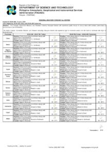
Mindanao Weather Conditions
A number of Mindanao provinces along the island’s eastern seaboard are under the more direct influence of the prevailing easterlies, according to PAGASA. Dinagat Islands, Surigao del Norte, Surigao del Sur, and Davao Oriental will experience partly cloudy to overcast skies with isolated rain showers or thunderstorms driven by these easterly wind currents.
The remainder of Mindanao — encompassing Davao Region provinces (except Davao Oriental), Northern Mindanao, the Zamboanga Peninsula, SOCCSKSARGEN, and the Bangsamoro Autonomous Region in Muslim Mindanao (BARMM) — will also have partly cloudy to cloudy skies with isolated showers or thunderstorms, this time from localized convective activity.
PAGASA warned that severe thunderstorms anywhere in Mindanao could generate flash floods and landslides. Provinces along Mindanao’s eastern coastline — particularly Surigao del Sur and Davao Oriental — face more sustained rainfall risk given their direct exposure to the easterlies throughout the day.
Wind direction over Mindanao will be from the east to northeast at light to moderate strength, a slightly different orientation compared to the southeast-to-southwest pattern observed over Luzon and Visayas. Coastal waters off Mindanao are forecast to be slight to moderate, with wave heights ranging from 0.6 to 1.2 meters.
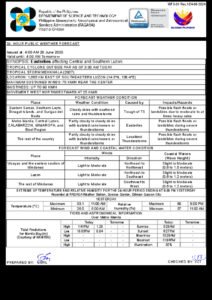
Temperature and Humidity Readings
Reference temperature and humidity data recorded at PAGASA’s Science Garden weather station in Diliman, Quezon City reflect the warm, muggy conditions driving afternoon thunderstorm development. During the 24-hour period that ended at 8:00 PM on Monday, June 15, the station logged a peak temperature of 31.0°C at 2:00 PM and a minimum of 26.0°C at 6:30 AM, PAGASA reported.
Relative humidity at the station swung between a high of 91 percent — indicating near-saturated air — and a low of 64 percent. These readings underscore the oppressively humid environment that serves as the fuel for convective thunderstorms across much of the lowland Philippines during this season. Residents are encouraged to drink plenty of fluids, limit prolonged outdoor exposure during peak afternoon heat, and seek immediate shelter when thunder is audible.
Sunrise, Moonrise, and Tidal Data
For Metro Manila on Tuesday, June 16, the sun is scheduled to rise at 5:27 AM and set at 6:26 PM, according to astronomical data in the PAGASA forecast. The moon is currently at just 3 percent illumination, close to the new moon phase, having risen at 6:18 AM and expected to set at 7:53 PM. The near-absence of moonlight means that communities without adequate street lighting will face particularly dark conditions if thunderstorms continue into the evening hours.
Tidal data for Manila Bay, sourced from the National Mapping and Resource Information Authority (NAMRIA), indicates a high tide of 1.54 meters at 9:56 AM and a low tide of -0.32 meters at 6:52 PM on Tuesday. NAMRIA’s figures are especially relevant for coastal barangays around Manila Bay, where storm runoff or surge associated with severe thunderstorms could compound tidal inundation risks. Residents in low-lying waterfront areas are advised to stay alert to rapidly changing water levels throughout the day.
Originally reported by: Breaking News Negros Oriental / wire reports