QUEZON CITY, June 19, 2026 — Filipinos across all major island groups should brace for an unsettled Friday, as the state weather bureau has placed virtually every region of the country under a forecast of scattered rainshowers and isolated thunderstorms that carry the potential to trigger flash floods and landslides in at-risk communities.
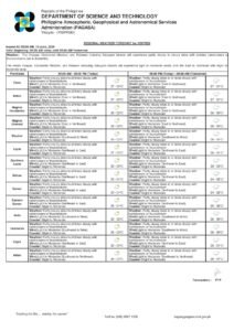
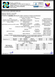
The Philippine Atmospheric, Geophysical and Astronomical Services Administration (PAGASA) released its 24-hour public weather forecast at 4:00 AM on June 19, 2026, valid through 4:00 AM on Saturday, June 20. The agency identified the easterlies — warm, moisture-rich winds blowing in from the Pacific Ocean — as the dominant weather system currently affecting Central Luzon, Southern Luzon, and the Visayas. Localized thunderstorm activity, meanwhile, is responsible for unsettled conditions in areas not directly under the easterlies’ influence.
No Tropical Cyclone in the Picture
Despite widespread rain across the archipelago, PAGASA confirmed that no tropical cyclone is present within the Philippine Area of Responsibility (PAR) as of the bulletin’s issuance. The agency noted that the combined effect of the easterlies and convective thunderstorm development is more than sufficient to sustain widespread cloud cover, intermittent showers, and isolated severe weather events without the presence of a named storm system.
Travelers and outdoor workers throughout the country are advised to anticipate on-and-off rainfall during the day, with sudden bursts of intense rain possible at any time. Severe thunderstorm episodes may temporarily affect road conditions, transportation, and outdoor activities.
Luzon: Metro Manila and Surrounding Regions
Metro Manila
The National Capital Region is forecast to have partly cloudy to cloudy skies with isolated rainshowers or thunderstorms throughout the day. PAGASA advises Metro Manila residents to carry rain gear and to exercise caution when moving through low-lying districts with a known history of flooding during heavy downpours.
Winds across Luzon are blowing from the east to southeast at light to moderate speeds. Temperature data recorded at PAGASA’s Science Garden monitoring station in Diliman, Quezon City showed that on the previous day, the mercury climbed to a high of 34.2°C at 11:00 AM and dipped to a low of 25.2°C at 6:00 AM. Relative humidity ranged between 46% and 89%, consistent with the warm and sticky conditions characteristic of the June easterly season.
Central Luzon and CALABARZON
Both Central Luzon — covering Bulacan, Pampanga, Tarlac, Nueva Ecija, Bataan, and Zambales — and CALABARZON (the provinces of Cavite, Laguna, Batangas, Rizal, and Quezon) are under the same easterly-driven forecast of partly cloudy to cloudy skies with isolated rainshowers or thunderstorms. PAGASA specifically flagged communities near riverbanks and at the base of hills and mountain ranges in these regions as being at elevated risk for flash floods and landslides should thunderstorms intensify.
MIMAROPA
The island group of MIMAROPA — comprising Mindoro, Marinduque, Romblon, and Palawan — is also under the influence of the easterlies, with a forecast of partly cloudy to cloudy skies with isolated rainshowers or thunderstorms. Residents in the mountainous interior and coastal zones of Palawan and Mindoro are urged to stay alert during any prolonged rainfall episodes.
Bicol Region
Camarines Norte, Camarines Sur, Albay, Sorsogon, Masbate, and Catanduanes — collectively forming the Bicol Region — are included in the easterly-influenced forecast zone and will see partly cloudy to cloudy skies with isolated rainshowers or thunderstorms. PAGASA noted that the region’s terrain, which includes active volcanic slopes and extensive river systems, heightens landslide and flooding risks even from moderate rainfall. Residents in hillside and low-lying areas are encouraged to closely follow weather updates throughout the day.
Northern Luzon
Regions not individually enumerated in the PAGASA bulletin — including the Ilocos Region, Cagayan Valley, Cordillera Administrative Region (CAR), and Aurora — fall under the general national forecast of partly cloudy to cloudy skies with isolated rainshowers or thunderstorms driven by localized convective activity. The agency reminded residents in Cordillera mountain provinces that steep and rugged terrain significantly amplifies landslide hazards, even when rainfall amounts appear moderate.
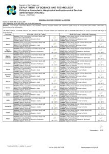
Visayas: Easterlies Bring Scattered Rain
All three Visayas regions — Western, Central, and Eastern Visayas — will experience partly cloudy to cloudy skies with isolated rainshowers or thunderstorms, according to PAGASA, as the easterlies continue to sweep across the island group.
Winds over the Visayas are blowing from the east to northeast at light to moderate intensity. Coastal wave heights in Visayan waters are forecast between 0.6 and 1.2 meters, which PAGASA classifies as slight to moderate. While these wave conditions are generally navigable, the agency cautioned operators of small bancas and outrigger fishing vessels to remain close to shore and exercise vigilance, as thunderstorm episodes can rapidly generate choppy seas with little advance warning.
Flash floods and landslides are flagged as hazards across Visayan provinces during severe thunderstorm events, most notably in the hilly and mountainous interior communities of Leyte, Samar, Negros, Cebu, and Panay.
Mindanao: Localized Thunderstorms at Play
Unlike the rest of the Philippines, which is primarily affected by the easterlies, Mindanao’s unsettled weather is attributed by PAGASA to localized thunderstorm activity. The forecast for the southern island group is partly cloudy to cloudy skies with isolated rainshowers or thunderstorms.
Winds over Mindanao are shifting from the northeast to northwest at light to moderate speeds — a slightly different wind pattern compared to the northern and central portions of the archipelago. Coastal waters surrounding Mindanao, including those of the Sulu Sea and nearby straits, are likewise expected to register wave heights of 0.6 to 1.2 meters.
The agency warned that flash floods and landslides are possible in Mindanao’s mountainous interior zones and river basin communities — including areas within Davao Region, Caraga Region, the Bangsamoro Autonomous Region in Muslim Mindanao (BARMM), and Northern and Southern Mindanao — particularly where thunderstorms are prolonged or severe.
Wind and Wave Conditions Nationwide
PAGASA classified winds across all three major island groups as light to moderate, which does not pose a broad threat to maritime navigation under ordinary circumstances. However, the agency stressed that severe thunderstorms are capable of rapidly producing strong gusts and localized wave surges that could endanger small watercraft. Wave heights of 0.6 to 1.2 meters are forecast for coastal waters nationwide. Fishermen and maritime workers are strongly encouraged to monitor local bulletins before putting out to sea.
Manila Bay Tidal Data
According to tidal predictions furnished by the National Mapping and Resource Information Authority (NAMRIA), Manila Bay will register a high tide of 1.42 meters at 12:44 PM and a low tide of -0.09 meters at 9:24 PM on June 19. NAMRIA’s data indicates that coastal barangays fronting Manila Bay should factor these tidal peaks into their preparations, especially when heavy local rainfall coincides with high tide.
Sunrise, Sunset, and Lunar Data for Metro Manila
For Metro Manila, the sun is scheduled to rise at 5:28 AM and set at 6:27 PM today. The moon will rise at 9:32 AM and set at 10:25 PM, with a lunar illumination of 25%, placing it in the waxing crescent phase — a condition that offers minimal natural light during nighttime hours.
Who Should Exercise Extra Caution
PAGASA has specifically highlighted the dangers of flash floods and landslides during severe thunderstorm episodes for all regions. The agency identified several groups that should maintain heightened vigilance throughout the day:
- Residents of low-lying areas situated near rivers, creeks, esteros, and drainage channels
- Communities located on hillsides, slopes, or at the foot of mountain ranges
- Motorists navigating flood-prone roads and underpasses during heavy rain
- Fishing households and maritime workers operating in coastal and offshore waters
- Farmers and agricultural workers exposed to outdoor conditions throughout the day
The public is encouraged to consult PAGASA’s official website and social media channels for updated weather bulletins, particularly if conditions change significantly throughout the forecast period. Local government units in disaster-prone areas are likewise urged to maintain readiness and activate early warning systems as needed.
Originally reported by: PTV News / PAGASA Public Weather Forecast, June 19, 2026