Weather conditions across the Visayas — including Negros Oriental and its coastal communities — are set to be unsettled this Saturday, June 13, 2026, according to a forecast bulletin released by the Philippine Atmospheric, Geophysical and Astronomical Services Administration (PAGASA) at 5:00 AM. The agency warned the public to expect intermittent rainshowers alongside the possibility of thunderstorms throughout the day, even as no tropical cyclone currently threatens the region.
Temperatures in the Eastern Visayas zone are expected to stay warm and humid, ranging from a low of 26°C to a high of 33°C, PAGASA said. Despite the absence of a named storm, the state weather bureau cautioned that isolated weather episodes during the southwest monsoon season can develop quickly and still pose risks to outdoor activities, coastal travel, and agricultural work.
Saturday Weather Pattern: Partly Cloudy With Rain Bursts
PAGASA described skies over the Visayas as “partly cloudy to at times cloudy” — a wet-season pattern where sunshine briefly gives way to cloud build-up, followed by bursts of rain and occasional thunder. These episodes, the agency noted, are not the sustained downpours brought by a typhoon but rather scattered and localized events that can intensify without much warning.
Winds are forecast to blow lightly to moderately from the southwest to southeast direction, consistent with the prevailing habagat, or southwest monsoon, which historically dominates the Visayas weather pattern between June and September. This wind regime typically brings wetter afternoons and choppy coastal waters, making sea conditions variable through the course of the day.
The intermittent nature of the rain means that periods of fair weather will alternate with sudden showers, a combination that can be particularly deceptive for those planning outdoor activities. PAGASA’s advisory underscores the importance of monitoring real-time updates even when conditions appear calm in the morning.
Sea Conditions and Coastal Travel Advisories
For inter-island travelers heading out this Saturday, PAGASA rated coastal waters around Negros Oriental as “slight to moderate” — wave heights that are manageable but not entirely calm. Passengers on ferry routes such as Dumaguete–Cebu, Dumaguete–Siquijor, and Dumaguete–Dapitan are advised to check vessel schedules directly with their respective shipping lines or port authorities before departure, as sea conditions can shift quickly in the lead-up to afternoon thunderstorms.
Operators of fast-craft services and pump boats connecting Negros Oriental with Siquijor Island and neighboring provinces face heightened variability in sea state during the midday and early afternoon period. Travelers on these smaller vessels are encouraged to pay close attention to any updates issued by their operators or the Philippine Coast Guard throughout the morning.
Fisherfolk along the Negros Oriental coastline — from the southern communities of Siaton and Zamboanguita to the northern towns of Ayungon and Bindoy — should exercise caution before setting out to sea. While slight to moderate seas may be manageable for experienced boat operators, PAGASA’s forecast of possible thunderstorms introduces additional hazards including sudden gusts and lightning that warrant careful judgment.
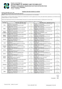
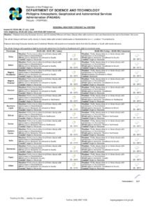
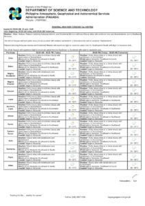
Areas Covered by the Visayas Regional Forecast
The PAGASA Visayas regional bulletin covers the entire province of Negros Oriental and its neighboring islands. Among the localities under the same weather pattern are:
- Dumaguete City — the provincial capital can expect on-and-off showers, with thunderstorm risk elevating during afternoon hours.
- Bayawan City — along the southwestern coast, residents should watch for squalls developing over the Tanon Strait.
- Bais City — intermittent rainfall is expected; vendors and public transport operators should monitor conditions closely.
- Guihulngan City — upland communities in the northern part of the province may experience heavier localized downpours due to elevated terrain.
- Siquijor Island — the neighboring island province falls under the same Visayas forecast, with similar partly cloudy skies and slight to moderate coastal waters.
- Cebu — also under the Visayas regional advisory, Cebu City and surrounding areas face the same wet-season weather pattern, relevant for travelers between the islands.
Extended Outlook: Rain Likely Through Sunday
Those hoping for drier conditions on Sunday may find little relief. PAGASA’s extended weather outlook, issued at 9:00 AM on Friday, June 12, 2026, projects that the weather pattern will remain largely unchanged through the weekend.
For the latter part of Saturday, the extended forecast shows a slight warming shift, with temperatures rising to a range of 27°C to 34°C — one degree higher on each end compared to the early morning outlook. Wind direction remains from the southwest to southeast, with coastal seas staying at slight to moderate levels.
By Sunday, temperatures are forecast to ease marginally back to 26°C to 33°C, according to PAGASA. Wind direction continues tracking from the southwest to southeast, signaling that the southwest monsoon will remain the dominant weather influence over the Visayas for at least several more days, sustaining the pattern of afternoon shower activity across the region.
Implications for Agriculture and Farm Communities
The weekend’s rainy weather carries both benefits and risks for Negros Oriental’s farming sector. The moisture brought by scattered rains supports rice, sugarcane, and vegetable crops grown across the province’s interior municipalities. However, PAGASA’s warning of possible thunderstorms also raises the risk of sudden heavy downpours and lightning exposure — hazards that are particularly acute for workers in open fields, on slopes, or near riverbanks during peak afternoon hours.
Farmers in upland barangays such as those in Valencia, Sibulan, and Santa Catalina are advised to complete field tasks in the earlier part of the morning and retreat to shelter before the afternoon thunderstorm window opens. Any harvested produce stored in the open should be covered or moved indoors to protect against unexpected heavy rain.
Public Safety Reminders
PAGASA confirmed that no gale warning has been issued for Negros Oriental waters and that no tropical cyclone is currently affecting the Visayas. Even so, the state weather bureau reminded the public that thunderstorms carry independent hazards — lightning strikes, localized flash flooding, and sudden gusty winds — that require standard precautions regardless of storm classification.
The agency’s general safety guidance includes the following reminders:
- Stay away from open fields, isolated tall trees, and elevated ridgelines when thunder and lightning are present.
- Refrain from crossing flooded roads, drainage areas, or low-lying passages during heavy rainfall.
- Secure outdoor furniture, equipment, and loose items that could be displaced by gusty winds accompanying thunderstorms.
- Keep mobile devices charged and stay tuned to official PAGASA bulletins and local government announcements for real-time updates.
The Visayas Regional Forecast cited in this report was issued by PAGASA at 5:00 AM on Saturday, June 13, 2026. The Extended Weather Outlook referenced was issued by PAGASA at 9:00 AM on Friday, June 12, 2026. Both bulletins are subject to revision as updated meteorological data becomes available. Residents, travelers, fisherfolk, and outdoor workers across Negros Oriental and the broader Visayas region are encouraged to visit the official PAGASA website at pagasa.dost.gov.ph for the most current forecasts.
Originally reported by: Breaking News Negros Oriental (breakingnewsnegrosoriental.com)