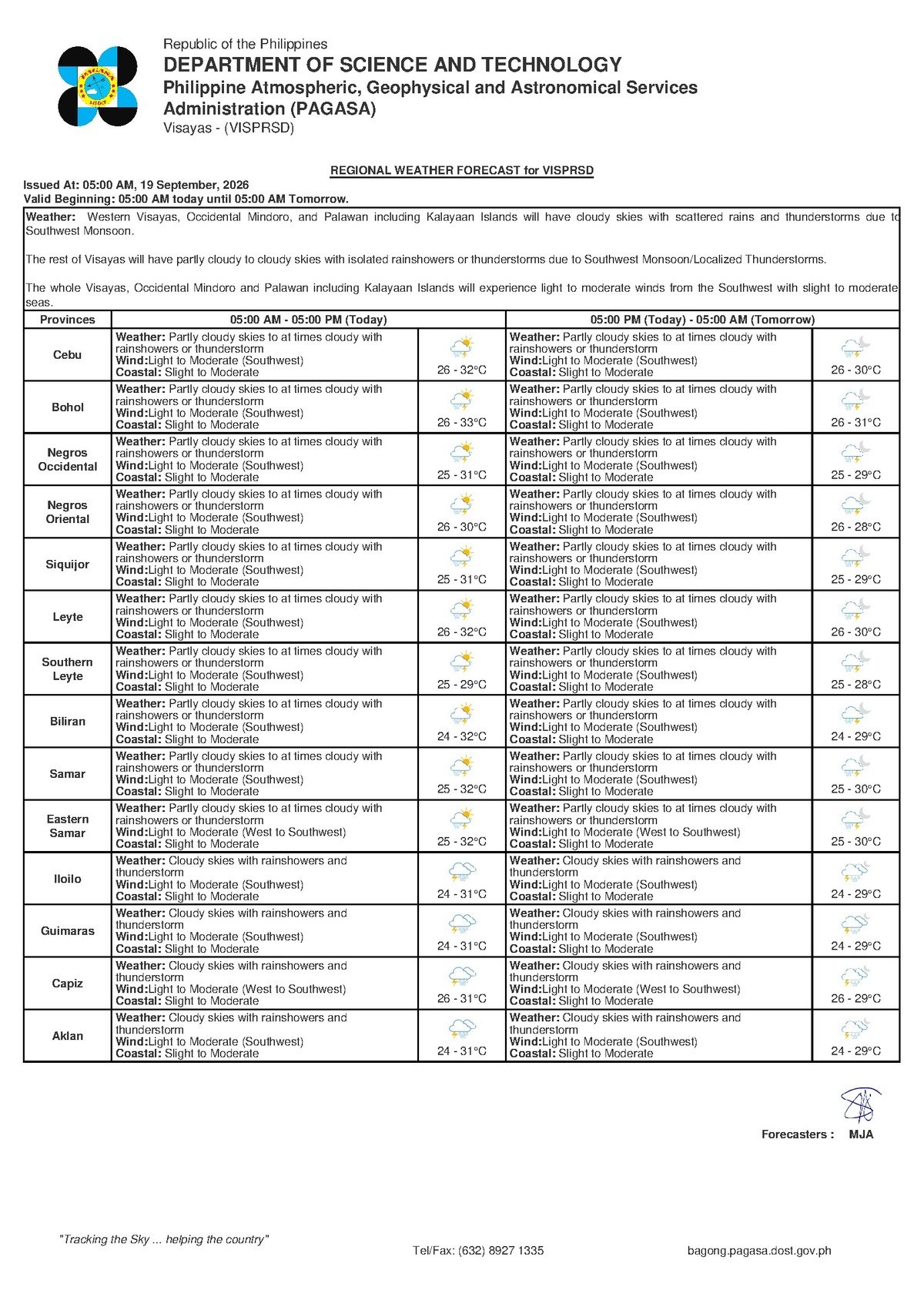
DUMAGUETE CITY — Saturday, September 19, 2026 — An active southwest monsoon is setting the tone for a wet and unsettled Saturday across Negros Oriental and the broader Visayas region, with the Philippine Atmospheric, Geophysical and Astronomical Services Administration (PAGASA) forecasting intermittent rainshowers and thunderstorms throughout the day. The agency released its regional bulletin at 5:00 AM, warning that the combination of cloudy skies, periodic heavy downpours, and possible lightning could affect outdoor activities, sea travel, and agricultural operations across the province.
Whether you are a commuter in Dumaguete City, a fisherfolk along the Tañon Strait, a farmer in the sugarcane fields of northern Negros Oriental, or a family planning a weekend outing, today’s forecast carries practical implications worth understanding before you head out the door.
The Weather Driver: Habagat in Full Force
According to PAGASA, surface winds across the Visayas are coming from the southwest — the defining signature of the habagat, or southwest monsoon. This seasonal wind pattern draws warm, moisture-saturated air from the direction of the South China Sea and Indian Ocean into the Philippine archipelago, and when it is active over the Visayas, it reliably produces the kind of weather being forecast today: overcast skies, periodic rainshowers, and thunderstorms that can develop — particularly during the afternoon and early evening — with little advance warning.
PAGASA’s extended forecast, which was issued at 9:00 AM on September 18, 2026, notes that this pattern is expected to persist into Sunday, with wind speeds remaining light to moderate from the southwest and coastal sea conditions staying at slight to moderate levels. Residents and travelers should carry the same level of readiness into the following day.
Temperature and General Sky Conditions
Temperatures across the Visayas — including Negros Oriental — are projected to range between a low of 26°C and a high of 32°C, which is consistent with typical September conditions in the region. However, PAGASA’s forecast notes that the combination of high humidity and on-and-off rainfall will make the atmosphere feel alternately muggy and unsettled throughout the day. Clear intervals may occur during the morning, but residents should not be lulled into a false sense of security: thunderstorms can build rapidly over the Visayas, shifting conditions from sunny to stormy in a matter of minutes.
The agency’s bulletin covers not only Negros Oriental but also the island province of Siquijor and neighboring Cebu, where the same partly cloudy to cloudy skies, rainshowers, and thunderstorm risk apply with the same temperature range.
Coastal Conditions and Sea Travel Advisory
For inter-island travelers and maritime workers, PAGASA classifies coastal waters along the shores of Negros Oriental — including the Tañon Strait and the Bohol Sea — as slight to moderate. The agency defines these sea state categories as follows:
- Slight (wave heights of approximately 0.1 to 0.5 meters): Generally navigable for most vessel sizes, though small banca operators are advised to remain cautious.
- Moderate (wave heights of approximately 0.5 to 1.25 meters): Uncomfortable and potentially hazardous for small, open watercraft; passengers on fast-craft ferries may experience rough conditions.
Because PAGASA describes the current classification as “slight to moderate” — meaning sea state could shift between the two levels — operators of small boats and fishing bancas are strongly advised to check actual conditions at the port before departing. Ferry passengers on routes such as Dumaguete–Siquijor or Dumaguete–Cebu, served by operators including OceanJet and Montenegro Lines among others, should verify sailing schedules directly with their carrier, as moderate swells may cause delays or affect passenger comfort.
PAGASA’s bulletin does not include any tropical cyclone wind signals, gale warnings, or color-coded rainfall advisories — yellow, orange, or red — for the Visayas region as of this forecast. However, the agency emphasizes that the presence of thunderstorms in the forecast itself constitutes a meaningful caution: thunderstorms can produce intense localized rainfall, dangerous lightning, and sudden wind gusts even in the absence of a formal warning signal.
Guidance for Different Sectors
Fisherfolk and Small Boat Operators
For fisherfolk operating out of Dumaguete, Bayawan, Bais, and coastal barangays throughout Negros Oriental, today’s conditions demand heightened vigilance. While light to moderate southwest winds and slight to moderate seas may be workable for larger motorized fishing vessels, small bancas and open boats face a more challenging situation — particularly given the added risk of sudden thunderstorms over open water. PAGASA advises that if a thunderstorm is visibly developing on the horizon, mariners should return to shore immediately rather than waiting for it to arrive.
Agricultural Workers and Farmers
Farmers across the province — including those tending sugarcane in the northern and central interior and vegetable growers in upland communities — should prepare for rain at irregular intervals throughout the day. While fieldwork during dry spells remains possible, workers should be ready to stop at the first sound of thunder. The agency’s forecast also signals concern for post-harvest crop drying: harvested crops left out in the open should be secured or covered before mid-morning, when afternoon thunderstorm development becomes more likely, according to PAGASA’s seasonal pattern guidance.
Commuters, Students, and Outdoor Events
Urban residents and commuters in Dumaguete and other population centres in Negros Oriental are advised to carry rain gear at all times today. Low-lying roads may experience temporary flooding during heavy rain bursts. For schools and families with weekend events or outdoor gatherings planned for Saturday, PAGASA’s thunderstorm forecast is a clear signal to prepare contingency arrangements — identifying indoor alternatives or designated shelters — and to assign someone to monitor sky conditions throughout any outdoor activity. Construction workers, market vendors, and delivery personnel should seek sturdy shelter immediately at the first sign of lightning or thunder, as the Philippine standard reminder applies: if thunder is audible, lightning strike range has already been entered.
The Weekend Outlook
Looking beyond Saturday, PAGASA’s extended weather outlook — issued at 9:00 AM on September 18, 2026 — projects that Sunday will bring broadly comparable conditions across Negros Oriental and the Visayas: temperatures remaining in the 26°C to 32°C range, light to moderate southwest winds, and slight to moderate coastal waters. The agency does not forecast any significant shift in the prevailing weather pattern over the two-day weekend period, meaning the level of preparedness appropriate for Saturday should be maintained into Sunday as well.
By the Numbers
- 5:00 AM: Time PAGASA released its Saturday regional forecast bulletin
- 9:00 AM, September 18, 2026: Time PAGASA issued its extended weekend outlook
- 26°C – 32°C: Forecast temperature range for the Visayas on Saturday
- 0.1 – 0.5 meters: Wave height range for “slight” coastal sea conditions
- 0.5 – 1.25 meters: Wave height range for “moderate” coastal sea conditions
Why This Matters
The active southwest monsoon affecting Negros Oriental this Saturday poses real, practical risks to maritime workers, farmers, and residents engaged in outdoor activities — risks that are compounded by the rapid development of thunderstorms, which can produce dangerous lightning and flash rainfall without the advance notice that formal warning signals typically provide. PAGASA’s forecast of persisting similar conditions through Sunday means these risks are not confined to a single day but extend across the entire weekend. Understanding the forecast categories — particularly the distinction between slight and moderate coastal conditions — enables residents, fisherfolk, and travelers to make informed, safety-conscious decisions before leaving home or shore.
Source: breakingnewsnegrosoriental.com / PAGASA regional weather bulletin, September 19, 2026