PHIVOLCS-DOST Bulletin — A Magnitude 4.2 earthquake was recorded near Occidental Mindoro on Friday afternoon, with monitoring instruments detecting weak shaking in two Mindoro cities but no expected damage or aftershocks, the Philippine Institute of Volcanology and Seismology (PHIVOLCS-DOST) reported.
Earthquake Details
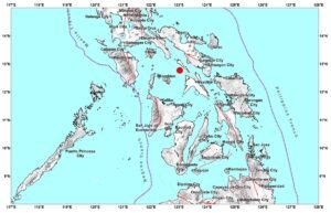
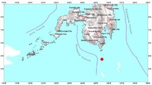
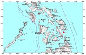
The tectonic earthquake struck at 1:30 PM on March 22, 2026, with its epicenter located 12 kilometers north-northwest of Abra De Ilog in Occidental Mindoro. PHIVOLCS recorded the event at coordinates 13.55°N, 120.70°E at a depth of 108 kilometers below the surface.
Intensity Reports
Seismic monitoring stations recorded Intensity I shaking in Mamburao, Occidental Mindoro and the City of Calapan in Oriental Mindoro. Under the PHIVOLCS Earthquake Intensity Scale, Intensity I represents scarcely perceptible shaking that is typically detected only by seismographic instruments and not felt by people.
Damage and Aftershock Assessment
PHIVOLCS assessed that the earthquake is not expected to cause damage to structures or property. The agency also determined that aftershocks are not anticipated following this seismic event.
Official Monitoring
The earthquake information bulletin was issued at 2:02 PM on March 22, approximately 32 minutes after the event occurred. PHIVOLCS indicated this will be the only bulletin released for this earthquake unless additional information becomes available.
The public is advised to monitor official PHIVOLCS updates at phivolcs.dost.gov.ph for the latest seismic information and advisories.