The Philippine Atmospheric, Geophysical and Astronomical Services Administration (PAGASA) warns of widespread thunderstorm activity and scattered rainfall across the country today, with easterly winds driving weather patterns from April 24, 2026, at 4:00 AM through tomorrow’s early morning hours.
In its latest 24-hour public weather forecast, the state weather bureau indicates that warm, moist easterly winds from the Pacific Ocean will predominantly impact the Visayas, Mindanao, and Southern Luzon regions, while the remainder of Luzon faces localized thunderstorm development.
Safety Concerns and Flood Warnings
Despite expectations of generally isolated and short-duration rainfall, PAGASA cautions that intense thunderstorms may produce flash floods or trigger landslides in susceptible areas. Communities located in flood-prone zones and landslide-vulnerable slopes should maintain heightened awareness and continuously monitor evolving weather conditions.
The weather bureau recommends avoiding low-lying areas during heavy rainfall episodes and staying clear of riverbanks and unstable terrain. Motorists face increased accident risks due to reduced visibility and slippery road surfaces during thunderstorm activity.
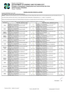
Mindanao Regional Forecast
Easterly wind influence will generate partly cloudy to cloudy conditions with isolated rainshowers and thunderstorms throughout Mindanao. This encompasses the Zamboanga Peninsula, Northern Mindanao, Davao Region, SOCCSKSARGEN, and the Bangsamoro Autonomous Region in Muslim Mindanao.
The Caraga region, including Agusan del Norte, Agusan del Sur, Dinagat Islands, Surigao del Norte, and Surigao del Sur, will experience similar partly cloudy to cloudy skies with scattered precipitation and thunderstorm activity caused by easterly winds.
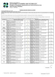
Visayas Weather Patterns
Easterly winds will produce partly cloudy to cloudy skies with isolated rainshowers and thunderstorms across the entire Visayas region. Western Visayas provinces—Aklan, Antique, Capiz, Guimaras, Iloilo, and Negros Occidental—will experience these weather conditions throughout the day.
Central Visayas, including Bohol, Cebu, Negros Oriental, and Siquijor, faces identical atmospheric conditions. Eastern Visayas provinces such as Biliran, Eastern Samar, Leyte, Northern Samar, Samar, Southern Leyte, and Western Samar will also encounter partly cloudy to cloudy skies with intermittent thunderstorm activity.
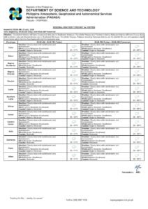
Luzon Weather Expectations
Localized thunderstorms will affect Northern Luzon, creating partly cloudy to cloudy conditions with isolated rainshowers and thunderstorms. This includes the Ilocos Region, Cagayan Valley, and Cordillera Administrative Region provinces.
Metro Manila and adjacent areas will experience similar weather patterns influenced by easterlies. Central Luzon provinces—Bulacan, Pampanga, Tarlac, Nueva Ecija, Bataan, and Zambales—will see partly cloudy to cloudy skies with scattered thunderstorms and rainfall.
CALABARZON territories of Cavite, Laguna, Batangas, Rizal, and Quezon, together with MIMAROPA provinces (Mindoro, Marinduque, Romblon, and Palawan), will experience easterly-driven weather patterns. The Bicol Region, covering Albay, Camarines Norte, Camarines Sur, Catanduanes, Masbate, and Sorsogon, will also see partly cloudy to cloudy conditions with isolated precipitation.
Wind Patterns and Marine Conditions
Light to moderate wind speeds are forecast nationwide today. Northern Luzon will experience southeast to south wind directions, while other regions will see east to southeast patterns. These wind speeds remain suitable for most outdoor activities and maritime operations.
Coastal waters will maintain slight to moderate conditions with wave heights between 0.6 and 1.8 meters in Northern Luzon coastal areas, while other regions experience waves ranging from 0.6 to 1.5 meters. These conditions generally support small watercraft operations, though mariners should exercise standard safety precautions.
Temperature and Atmospheric Data
Yesterday’s temperature readings at PAGASA’s Science Garden station in Diliman, Quezon City showed a maximum of 35.3°C at 4:00 PM and a minimum of 24.9°C at 6:00 AM. Relative humidity fluctuated from a peak of 73% at 6:00 AM to 33% at 4:00 PM, reflecting typical dry season humidity patterns.
Today’s sunrise time was 5:37 AM, with sunset scheduled for 6:12 PM. The moon will appear at 11:55 AM and set at 12:18 AM tomorrow, providing 54% illumination for moderate nighttime visibility.
Marine and Aviation Advisories
Fishing communities and marine vessel operators should review coastal water conditions and prevailing wind patterns before departing. Although conditions remain generally conducive to maritime activities, rapid weather changes during thunderstorms can create dangerous situations at sea.
Those planning outdoor activities should observe sky conditions and seek appropriate shelter when rapidly developing dark clouds appear. The combination of lightning, heavy rainfall, and strong winds during thunderstorms poses significant safety risks.
PAGASA’s current forecast remains effective until 4:00 AM on April 25, 2026. Citizens are advised to monitor official weather updates through pagasa.dost.gov.ph for the most current meteorological information and weather advisories.