QUEZON CITY, June 8, 2026 — Moisture-laden winds from the Southwest Monsoon — the seasonal weather pattern Filipinos call Habagat — are pushing scattered rains and thunderstorms into the western flanks of Northern and Central Luzon this Monday, raising the alarm for potential flash floods and landslides particularly in the Ilocos Region and the province of Zambales. Elsewhere across the archipelago, heat-driven localized thunderstorms are expected to produce brief but intense downpours over Metro Manila, the Visayas, and Mindanao throughout the day.
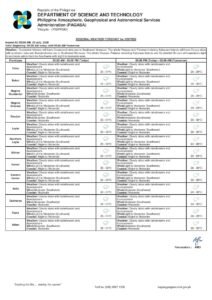
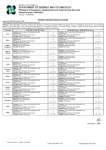
The Philippine Atmospheric, Geophysical and Astronomical Services Administration (PAGASA) released its official 24-hour public weather forecast at 4:00 AM on June 8, 2026, covering the period through 4:00 AM of the following day, June 9, 2026. The bulletin describes a country under broadly unsettled atmospheric conditions shaped by two separate but simultaneously active weather drivers.
Two Weather Systems at Work
According to PAGASA, the Southwest Monsoon is the dominant weather system influencing the country on Monday. This seasonal wind pattern, which typically prevails from June through September, channels warm, humid air directly into the western sections of Northern and Central Luzon — the same coastline-facing areas that have historically received prolonged and heavy rainfall during the rainy season.
On the other hand, the weather agency noted that the rain expected over Metro Manila and the bulk of the Philippine archipelago has a different origin: localized thunderstorm activity generated by daytime heat and atmospheric instability. Unlike monsoon-driven rain, which can persist for hours or even days, these convective storms tend to build quickly, often in the afternoon and early evening, and can deliver intense bursts of rainfall within a short period even if they do not cover as wide an area.
Western Luzon Bears the Brunt
PAGASA’s forecast places the Ilocos Region and Zambales at the center of the most significant weather hazard for June 8. Both areas are expected to see cloudy skies with scattered rains and thunderstorms under the direct influence of the Southwest Monsoon. The agency explicitly warns that flash floods and landslides are possible in these localities due to moderate to at times heavy rainfall.
The Ilocos Region comprises the provinces of Ilocos Norte, Ilocos Sur, La Union, and Pangasinan — areas along the northwestern coast of Luzon that are particularly exposed to habagat moisture. Residents living near rivers, along slopes, or in low-lying communities within these provinces, as well as in Zambales, are urged by the weather bureau to stay on alert and follow advisories from local government units.
PAGASA further noted that communities in the Cordillera Administrative Region and other parts of Northern Luzon not explicitly named in the bulletin should also exercise caution. The reach of the monsoon can vary, and localized conditions may differ from area to area within the broader forecast zone.
For Metro Manila and the rest of Luzon, PAGASA categorized the outlook as partly cloudy to cloudy with isolated rain showers or thunderstorms. The weather agency cautioned, however, that flash floods and landslides remain a possibility in the capital and surrounding provinces during severe thunderstorms. Urban areas are particularly vulnerable to rapid flooding when heavy rain overwhelms drainage infrastructure within a short span of time.
Visayas: Isolated but Potentially Intense Storms
Across the Visayas — spanning the Eastern, Central, and Western Visayas island groups — the forecast calls for partly cloudy to cloudy skies with isolated rain showers or thunderstorms. PAGASA attributed these weather disturbances to localized thunderstorm activity rather than any large organized weather system moving through the region.
The weather bureau issued the same flash flood and landslide caution for the Visayas as it did for Metro Manila, noting that severe localized storms can still pose serious risks. Residents of provinces such as Leyte, Samar, Cebu, Negros, Iloilo, and Antique are advised to closely monitor sky conditions in the afternoon hours, when convective storms typically reach peak intensity. Those in hilly terrain and low-lying coastal communities should be especially vigilant.
Mindanao: Relatively Calm but Not Without Risk
Mindanao falls under the same general forecast as most of the country outside monsoon-affected western Luzon — partly cloudy to cloudy with isolated rain showers or thunderstorms driven by localized thunderstorm activity. Despite the relatively benign-sounding outlook, PAGASA’s flash flood and landslide advisory during severe thunderstorms applies fully to Mindanao’s provinces.
The weather agency’s cautionary note carries added weight given Mindanao’s complex terrain, which includes major mountain ranges, large river systems, and areas with documented histories of flash flooding. Provinces such as Davao, Bukidnon, Lanao del Norte, Lanao del Sur, and the Caraga Region are reminded to monitor local conditions closely and not to dismiss storm warnings, even when the general forecast appears moderate.
Winds and Coastal Water Conditions
PAGASA also detailed wind and sea conditions in Monday’s forecast bulletin, with notable differences between the country’s far north and the rest of the archipelago.
Over Extreme Northern Luzon — specifically the seaboards of Batanes and the northernmost sections of Cagayan province — winds are blowing from the south to southwest at moderate speeds. Coastal waters in this zone are classified as moderate, with wave heights between 1.2 and 2.5 meters. The weather agency strongly advises mariners, fisherfolk, and operators of small watercraft to exercise caution when navigating these waters.
For the rest of the country, the weather bureau reported southeast to southwest winds at light to moderate intensity. Coastal waters are classified as slight to moderate, with wave heights ranging from 0.6 to 1.5 meters. While these conditions are less severe than those in the far north, PAGASA reminded those planning sea travel to verify conditions before setting out, as even moderate waves can pose risks to small bancas and fishing vessels.
Temperature and Humidity in Quezon City
PAGASA reported that at its official weather station at Science Garden in Diliman, Quezon City, the maximum temperature for the 24-hour period ending at 8:00 PM on June 7, 2026 reached 33.3°C at 2:00 PM, while the minimum temperature dropped to 25.6°C at 5:00 AM. Relative humidity peaked at 91% in the early morning hours and fell to 51% during the afternoon heat.
These figures, the agency noted, are consistent with the warm and humid baseline conditions typical of the Philippine rainy season. High overnight humidity combined with afternoon heat creates the atmospheric instability that fuels the convective thunderstorms forecast for much of the country outside monsoon-affected zones.
Sunrise, Moonlight, and Tidal Data for Metro Manila
For residents of Metro Manila planning outdoor activities, PAGASA reported that sunrise on June 8 is at 5:26 AM and sunset at 6:24 PM, providing approximately 13 hours of daylight. The moon rises at 11:44 AM and is currently at 49% illumination, nearing the first quarter phase.
In coordination with the National Mapping and Resource Information Authority (NAMRIA), PAGASA also published tidal predictions for Manila Bay. A high tide of 0.99 meters is forecast at 2:45 PM, followed by a low tide of 0.13 meters at 11:08 PM. Coastal communities and low-lying barangays near Manila Bay are advised to take these tidal cycles into account, especially during periods of afternoon thunderstorm activity when combined rainfall runoff can elevate localized flooding risk.
Public Safety Reminders
Given the range of weather hazards in Monday’s forecast — from monsoon-driven rains in western Luzon to fast-forming afternoon thunderstorms across the rest of the country — PAGASA and local disaster risk reduction authorities urge the public to stay informed through official weather updates. Residents in flood-prone and landslide-susceptible areas are advised not to wait for conditions to worsen before taking precautionary action. Those near rivers, slopes, and coastal zones should maintain readiness to evacuate if local officials issue the order.
The weather agency reminds the public to rely on official PAGASA bulletins and to avoid spreading unverified weather information on social media, which can cause unnecessary panic or, conversely, false reassurance during genuinely dangerous conditions.
Originally reported by: wire reports