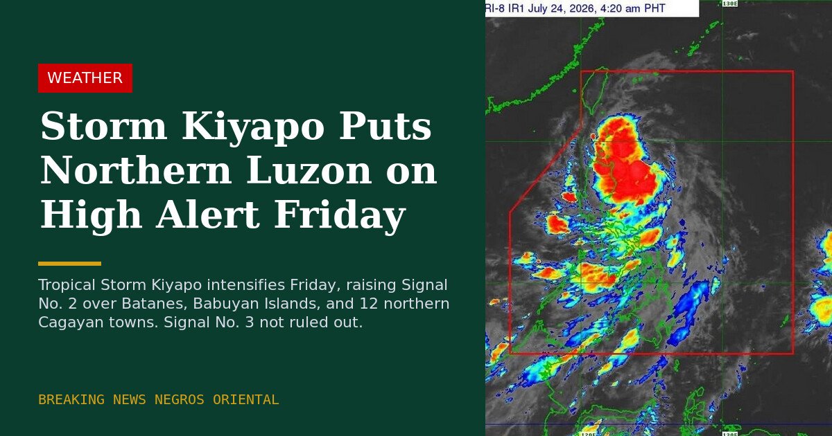
Early in the morning of Friday, July 24, 2026, Tropical Storm Kiyapo — carrying the international name Noul — gained strength as it approached the northern tip of the Philippines, compelling the Philippine Atmospheric, Geophysical and Astronomical Services Administration (PAGASA) to place several northern areas under Tropical Cyclone Wind Signal No. 2. The bulletin triggered warnings across Batanes, the Babuyan Islands, and more than a dozen towns in Cagayan province, with the storm on a direct course toward extreme northern Luzon.
According to PAGASA’s 5:00 a.m. bulletin issued that Friday, the center of Kiyapo was located approximately 345 kilometers east of Aparri, Cagayan. The storm carried maximum sustained winds of 65 kilometers per hour near its center, with gusts peaking at 80 kph. Its central pressure was recorded at 998 hectopascals (hPa), and it was advancing in a west-northwestward direction at a speed of 30 kph.
Signal No. 2 and Signal No. 1 Coverage Areas
Signal No. 2 — which warns residents of gale-force winds between 62 and 88 kph expected within 24 hours — was raised over Batanes and the Babuyan Islands. Also under Signal No. 2 were 12 municipalities in the northern part of mainland Cagayan: Santa Ana, Gonzaga, Santa Teresita, Buguey, Camalaniugan, Aparri, Ballesteros, Abulug, Pamplona, Sanchez-Mira, Claveria, and Santa Praxedes. Pagudpud in Ilocos Norte was likewise included under the same signal level, PAGASA reported.
Signal No. 1, covering areas where strong winds of 39 to 61 kph are expected within 36 hours, was placed over a broader swath of northern and central Luzon. This included the rest of mainland Cagayan, Isabela, Nueva Vizcaya, Quirino, Apayao, Abra, Kalinga, Mountain Province, Ifugao, Benguet, the remainder of Ilocos Norte, Ilocos Sur, La Union, and the northern and central portions of Aurora.
The weather bureau did not dismiss the possibility of escalating the warning to Signal No. 3 in the event that Kiyapo intensifies into a severe tropical storm while traversing the Batanes-Babuyan corridor.
Forecast Track: Kiyapo’s Path Through the Region
PAGASA outlined a west-northwestward trajectory for Kiyapo continuing through Saturday, when the storm is expected to approach the Luzon Strait before curving northwestward and eventually northward. The storm’s center was projected to pass close to the northeastern portion of mainland Cagayan between Friday morning and afternoon.
From Friday afternoon into the evening, PAGASA forecast that Kiyapo’s center would pass very close to or make direct landfall over the Babuyan Islands. The storm is then expected to exit the Philippine Area of Responsibility by Saturday morning.
Upon leaving the Babuyan Islands, PAGASA noted that Kiyapo could be upgraded to severe tropical storm status and may undergo rapid intensification over the West Philippine Sea. The storm could potentially reach typhoon strength before making landfall over southern mainland China, where it is expected to weaken as it moves inland.
Enhanced Southwest Monsoon to Affect Broader Areas
Beyond its direct path, Kiyapo’s outer rainbands are expected to energize the southwest monsoon, spreading strong to gale-force wind gusts across most of the country on Friday, particularly in coastal and elevated areas exposed to wind. PAGASA cautioned residents in these zones to remain alert even if far from the storm’s center.
The weather bureau added that gusty conditions would persist into Saturday over most of Luzon and the Visayas, as well as Zamboanga del Norte and Davao Oriental. By Sunday, the wind hazard area is expected to contract to the Ilocos Region, Zambales, Bataan, Occidental Mindoro, and the Kalayaan Islands, according to PAGASA’s bulletin.
Dangerous Maritime Conditions Off Northern Coasts
A gale warning remained in force along the northern seaboard of Northern Luzon as of Friday morning. PAGASA warned of waves reaching up to 5.5 meters off Batanes and the Babuyan Islands, and up to 4.5 meters along the northern seaboards of mainland Cagayan and Ilocos Norte. The weather bureau declared sea travel in those waters dangerous for vessels of all sizes and tonnage.
Rougher-than-normal seas of up to 3.0 meters were forecast for the remaining seaboards of mainland Cagayan and Ilocos Norte, as well as the eastern seaboard of Davao Oriental. Moderate to rough seas reaching up to 2.0 meters were expected over several bodies of water around the Visayas and Mindanao, including the southern and western seaboards of Guimaras and Negros Occidental, and the southern seaboard of Iloilo. PAGASA advised operators of motorbancas and other small watercraft in those areas to exercise precaution given the elevated sea state.
PAGASA Calls on Local Disaster Agencies to Act
The weather bureau urged local disaster risk reduction and management councils across all affected areas to implement protective measures for both lives and property without delay. Residents in communities identified as highly vulnerable to wind damage and flooding were directed to heed evacuation orders and advisories from their local government officials.
PAGASA announced that its next scheduled weather bulletin would be released at 8:00 a.m. on Friday, July 24, 2026, with updates to continue as the storm progressed.
By the Numbers
- 345 km — Distance of Kiyapo’s center east of Aparri, Cagayan, per the 5:00 a.m. PAGASA bulletin
- 65 kph — Maximum sustained winds near the storm’s center
- 80 kph — Peak wind gusts recorded near Kiyapo’s center
- 998 hPa — Central pressure of Tropical Storm Kiyapo
- 30 kph — Forward speed of the storm moving west-northwestward
- 5.5 meters — Projected wave heights off Batanes and the Babuyan Islands
- 4.5 meters — Forecast wave heights off the northern Cagayan and Ilocos Norte seaboards
- 12 towns — Number of northern Cagayan municipalities under Signal No. 2
- 2.0 meters — Moderate to rough seas forecast over parts of Visayas and Mindanao waters
Why This Matters
Tropical Storm Kiyapo represents a direct and immediate hazard to communities across extreme northern Luzon, with Signal No. 2 already active and the threat of a Signal No. 3 escalation if the storm intensifies further over the Batanes-Babuyan corridor. PAGASA’s declaration that sea travel is dangerous for all vessel types along affected northern seaboards disrupts vital maritime routes serving some of the Philippines’ most geographically isolated island communities. The enhancement of the southwest monsoon by Kiyapo’s outer bands extends wind and sea hazards far beyond the storm’s immediate track, placing communities across Luzon, the Visayas, and portions of Mindanao at risk well into the weekend.
Source: PAGASA / wire reports