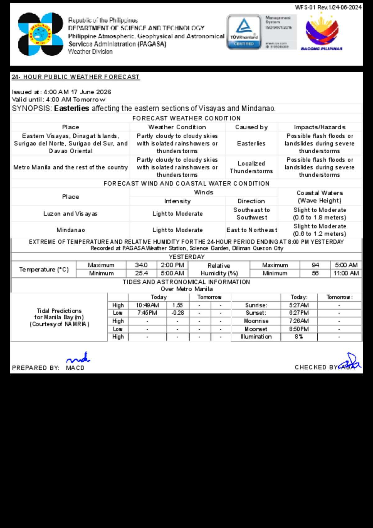
The entire Philippine archipelago is bracing for a day of unsettled skies and intermittent downpours on Wednesday, June 17, 2026, as the Philippine Atmospheric, Geophysical and Astronomical Services Administration (PAGASA) places all major island groups under its flash flood and landslide advisory. The agency released its 24-hour public weather forecast at 4:00 AM Wednesday, with validity extending through 4:00 AM on Thursday, June 18.
No active tropical cyclone is currently affecting the country, PAGASA confirmed. In its place, two key weather drivers are shaping conditions: the easterly winds directly impacting eastern Visayas and Mindanao, and localized convective activity bringing thunderstorms to Metro Manila and the rest of the country. The combination produces widespread cloud cover, sudden heavy rains, and elevated hazard risks for communities nationwide.
What Is Driving Wednesday’s Weather
According to PAGASA, the absence of a tropical cyclone does not diminish the potential severity of Wednesday’s weather. Localized thunderstorms — generated by daytime surface heating and atmospheric moisture — can develop rapidly and intensify during the afternoon and early evening, when ground temperatures are at their highest. Meanwhile, the easterlies blowing in from the Pacific Ocean are carrying substantial moisture into the eastern flanks of Visayas and Mindanao, sustaining persistent cloud cover and rainfall in those areas.
PAGASA specifically warned the public of the risk of flash floods and landslides during severe thunderstorm episodes across all regions. Households living near rivers, drainage channels, and steep hillside communities are considered especially vulnerable and are advised to closely monitor local government advisories throughout the day.
Luzon Weather Outlook
Metro Manila and the broader Luzon region will experience partly cloudy to cloudy skies with isolated rain showers and thunderstorms on Wednesday, driven by localized convection rather than any organized weather system, PAGASA said in its morning forecast bulletin.
The advisory covers provinces across all of Luzon’s major subregions — from Ilocos and Cagayan Valley in the far north, through Central Luzon and CALABARZON in the heartland, down to the Bicol Peninsula in the south. Sudden, intense downpours are possible at any hour of the day, though the late afternoon period carries the highest risk of severe storm development. In urban low-lying areas, flash flooding remains a concern, while mountainous and hilly provinces face the additional threat of landslides.
Winds over Luzon will be light to moderate, blowing from the southeast to southwest direction. Coastal waters surrounding the island are classified as slight to moderate, with wave heights forecast between 0.6 and 1.8 meters. PAGASA advises mariners and fisherfolk to exercise caution, as wave conditions can deteriorate quickly during active thunderstorm periods.
Visayas Weather Outlook
The Visayas region will be subject to a dual weather influence on Wednesday. Eastern Visayas — comprising the provinces of Samar, Eastern Samar, Northern Samar, Leyte, Southern Leyte, and Biliran — will experience partly cloudy to cloudy skies with isolated rain showers or thunderstorms due to the direct effect of the easterlies, according to PAGASA’s forecast. This Pacific-originating wind flow carries considerable moisture and tends to sustain cloud activity along the eastern seaboard throughout the day.
Central Visayas and Western Visayas will similarly contend with partly cloudy to cloudy conditions and isolated thunderstorms, though these are attributed to localized convective development rather than the easterly flow. Residents across all Visayas provinces — including those in known flood-prone and landslide-vulnerable localities in Leyte and Samar — are urged to remain on alert, as PAGASA’s flash flood and landslide warning covers the entire region.
Wind speeds over the Visayas are light to moderate, with a southeast-to-southwest direction. Coastal sea conditions are slight to moderate, with wave heights between 0.6 and 1.8 meters.
Mindanao Weather Outlook
Mindanao’s weather on Wednesday is similarly disturbed. Eastern-facing provinces — specifically Dinagat Islands, Surigao del Norte, Surigao del Sur, and Davao Oriental — will be most directly affected by the easterlies, PAGASA noted, and may see more prolonged cloud cover and rainfall activity compared to areas further inland.
The rest of Mindanao, including the Davao Region, Soccsksargen, the Zamboanga Peninsula, Northern Mindanao, the Bangsamoro Autonomous Region in Muslim Mindanao (BARMM), and remaining Caraga provinces, can expect partly cloudy to cloudy skies with isolated rain showers or thunderstorms resulting from localized convection.
Flash floods and landslides are flagged as hazards for Mindanao as well, per PAGASA’s bulletin. Communities in elevated areas such as Compostela Valley and Bukidnon, and those situated along major river systems, are specifically called out as needing to remain vigilant throughout the day.
Wind conditions over Mindanao differ slightly from those in Luzon and Visayas. Winds will blow from the east to northeast — a direct reflection of the easterly influence over the southern Philippines — at light to moderate speeds. Coastal waters around Mindanao are slightly calmer, with wave heights forecast between 0.6 and 1.2 meters.
Metro Manila Temperature and Humidity Readings
PAGASA’s Science Garden weather station in Diliman, Quezon City recorded Metro Manila’s temperature extremes for the 24-hour period ending at 8:00 PM on Tuesday, June 16. The day’s peak temperature hit 34.0°C at 2:00 PM, while the overnight low dropped to 25.4°C at 5:00 AM. Relative humidity fluctuated from 94 percent in the early morning to a midday low of 56 percent at 11:00 AM — humidity levels consistent with the wet season pattern.
Even on a rainy day, temperatures during dry spells are expected to remain warm. With high humidity factored in, the heat index — commonly described as the “feels like” temperature — could push apparent temperatures well above the recorded figure during breaks between rain showers, PAGASA noted.
Sun, Moon, and Tidal Data for Metro Manila
On Wednesday, June 17, the sun will rise over Metro Manila at 5:27 AM and set at 6:27 PM. The moon will rise at 7:26 AM and set at 8:50 PM, with a lunar illumination of just 8 percent, making nighttime conditions notably dark for areas without adequate artificial lighting.
Tidal data for Manila Bay, as provided by the National Mapping and Resource Information Authority (NAMRIA), shows a high tide of 1.55 meters at 10:49 AM and a low tide of -0.28 meters at 7:45 PM. Coastal and low-lying communities along Manila Bay should take note of these tidal cycles, as any coincidence of heavy rainfall and high tide can amplify localized flood risks in bayside neighborhoods.
Public Safety Advisories
With PAGASA placing all regions under a flash flood and landslide watch, authorities and the weather agency are urging the public to take practical precautions throughout Wednesday. Do not attempt to cross flooded roads, bridges, or waterways — floodwater depth and current speed are often greater than they appear at the surface. Residents in hillside communities should monitor advisories from their local government units and be ready to evacuate at short notice if conditions worsen.
Motorists are advised to reduce speed and increase road following distances during heavy rain episodes, when visibility drops sharply. Those in coastal areas or engaged in maritime activities should avoid unnecessary sea travel during thunderstorm activity, given the potential for sudden changes in wave conditions.
PAGASA will continue to issue updated forecasts as Wednesday’s weather evolves. The public is encouraged to follow official PAGASA channels — including its website, social media accounts, and regional offices — for the most current advisories and warnings.
“Possible flash floods or landslides during severe thunderstorms” — PAGASA, 24-Hour Public Weather Forecast, 4:00 AM, June 17, 2026
Originally reported by: wire reports