Seismic activity rattled parts of the Bicol Region and nearby provinces on the morning of Monday, July 13, 2026, after a magnitude 5.4 earthquake was detected off the coast of Claveria in Masbate. The Philippine Institute of Volcanology and Seismology (PHIVOLCS-DOST) logged the event and issued an official bulletin confirming the tremor was felt across multiple provinces, though no damage is anticipated.
Details of the Seismic Event
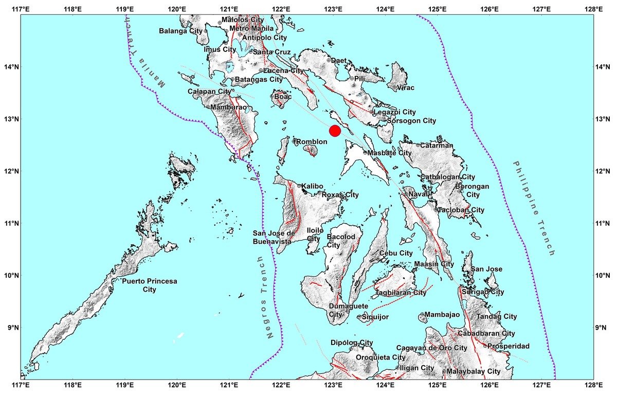
According to PHIVOLCS-DOST, the earthquake occurred at precisely 8:54:02 in the morning, Philippine Standard Time. The epicenter was placed 27 kilometers south-southwest of Claveria, Masbate, at geographic coordinates 12.77°N, 123.04°E. PHIVOLCS recorded a focal depth of just 8 kilometers, which classifies this as a shallow-focus earthquake — the type generally capable of generating stronger surface shaking relative to its magnitude.
The agency identified the event as tectonic in origin, meaning it resulted from the natural movement and stress release along fault structures beneath the earth’s surface. PHIVOLCS catalogued it under Earthquake Information No. 3, with the official bulletin released at 1:04 PM PHT on the same day.
Intensity Levels Across Affected Areas
The most intense shaking was experienced in the municipality directly closest to the epicenter. PHIVOLCS-DOST reported that Claveria, Masbate registered Intensity V on the PHIVOLCS Earthquake Intensity Scale. At this intensity level, shaking is felt by virtually all residents; people who are asleep are likely to be jolted awake, some individuals may instinctively move outdoors, small objects can be knocked out of place, and liquids in open containers may slosh and spill.
Spreading outward, Intensity III — which involves hanging objects swinging visibly and most people indoors noticing the tremor — was reported in several municipalities. These include Aroroy, Baleno, and the City of Masbate in Masbate province; Cajidiocan, Magdiwang, and San Fernando in Romblon; the City of Legazpi in Albay; and Bulan, Donsol, Juban, Magallanes, and the City of Sorsogon in Sorsogon province, as documented in the PHIVOLCS bulletin.
At Intensity II, the earthquake was perceptible to a limited number of residents, particularly those who were sitting or lying still at the time. PHIVOLCS-DOST noted Intensity II reports from San Andres in Quezon and the City of Naga in Camarines Sur.
The weakest felt reports, Intensity I, came from Batuan, Mandaon, Palanas, and San Fernando in Masbate, as well as Romblon in Romblon province. At this level, the tremor is typically perceived only by particularly sensitive individuals or those located on higher building floors.
Instrumental Seismic Readings
Beyond what residents physically felt, PHIVOLCS-DOST also recorded instrumental intensity readings gathered from seismic sensors deployed across the region. These readings extend the picture of how broadly the earthquake’s energy radiated.
Instrumental Intensity III was recorded in the City of Legazpi and Aroroy, as well as in Castilla, Donsol, and the City of Sorsogon. Instrumental Intensity II readings were captured in Mandaon (Masbate); Gumaca and Mulanay in Quezon; the cities of Ligao and Tabaco in Albay; and the City of Iriga, Pili, Ragay, and Sipocot in Camarines Sur, according to PHIVOLCS data.
Instrumental Intensity I was detected in a wider set of localities including Batuan, Dimasalang, and San Fernando in Masbate; Odiongan in Romblon; Sagñay in Camarines Sur; Bulusan and Prieto Diaz in Sorsogon; Malinao in Aklan; and the City of Roxas in Capiz. This indicates that the earthquake’s seismic waves traveled considerable distances even as their energy diminished.
By the Numbers
- 5.4 — magnitude of the earthquake
- 8:54:02 AM PHT — time the earthquake struck on July 13, 2026
- 27 km — distance of the epicenter south-southwest of Claveria, Masbate
- 8 km — focal depth, confirming classification as a shallow earthquake
- Intensity V — strongest shaking reported, in Claveria, Masbate
- 1:04 PM PHT — time the PHIVOLCS bulletin was officially issued
Aftershock Advisory and Safety Guidance
PHIVOLCS-DOST stated that the magnitude 5.4 earthquake is not expected to result in structural damage. However, the agency cautioned that aftershocks remain a possibility following the main event. Residents in Masbate, Romblon, Sorsogon, Albay, Quezon, and Camarines Sur are advised to remain vigilant and to stay updated through official channels.
PHIVOLCS noted in the bulletin that this will serve as the final official release on the event unless new or significant information emerges. An epicentral map was included as part of the bulletin’s official documentation. The public may monitor further developments through the PHIVOLCS-DOST website at phivolcs.dost.gov.ph.
Why This Matters
Shallow-focus earthquakes like this magnitude 5.4 event carry a heightened potential for surface impact relative to deeper tremors of similar magnitude, making accurate and timely intensity reporting by PHIVOLCS-DOST critical for community preparedness. The wide geographic spread of shaking — from Masbate and Romblon to Bicol provinces and as far as Aklan and Capiz — underscores how a single seismic event can affect multiple provinces across the Visayas-Bicol corridor simultaneously. While no damage is foreseen in this instance, the advisory on possible aftershocks serves as a reminder for residents in seismically active zones to maintain readiness and heed guidance from official monitoring agencies.
Source: PHIVOLCS-DOST Earthquake Information Bulletin No. 3, July 13, 2026