DUMAGUETE CITY, Negros Oriental — October 26, 2026 — The Philippine Atmospheric, Geophysical and Astronomical Services Administration (PAGASA) has placed Negros Oriental under an unsettled weather outlook for the full 24-hour period beginning Monday morning, with its 5:00 AM forecast bulletin calling for rainshowers and thunderstorms from Dumaguete City in the south up to Guihulngan and Bais in the north, and extending to island communities in Siquijor.
PAGASA’s bulletin divides Monday into two forecast windows — daytime from 5:00 AM to 5:00 PM, and overnight from 5:00 PM to 5:00 AM Tuesday — with neither period expected to bring significantly settled conditions.
The Weather Driver: Northeast Monsoon
Winds over Negros Oriental are blowing from the northeast at light to moderate strength, according to PAGASA forecast data. This wind direction signals the influence of the amihan, or northeast monsoon — a large-scale seasonal wind system that draws cooler, moisture-laden air from the Pacific and the South China Sea into the eastern and central Philippines during the closing months of the year.
The amihan itself is not a storm system but a broad, sustained wind pattern. As this moist air is pushed inland and encounters the mountain ranges of Negros Island, it rises, cools, and condenses — generating cloud cover, rainshowers, and, when enough atmospheric instability builds up, thunderstorms. The result, as reflected in PAGASA’s forecast, is an on-and-off pattern of showers rather than a continuous downpour, with the potential for thunderstorms to flare up at various points through the day and night.
Official Forecast Figures for Negros Oriental
Daytime — 5:00 AM to 5:00 PM Monday
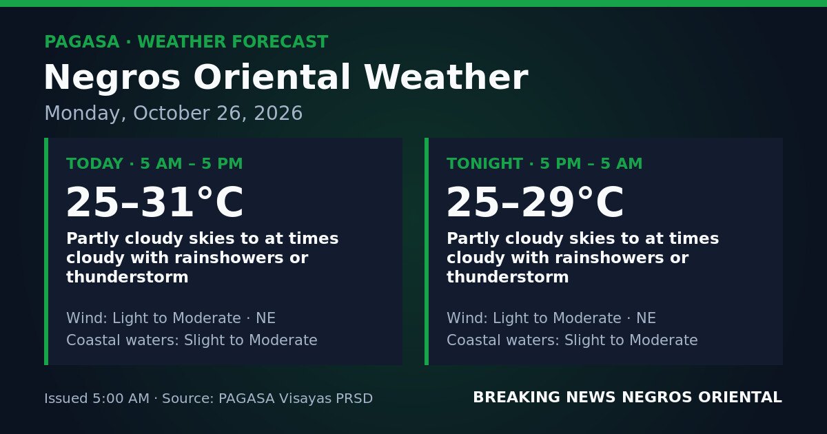
PAGASA describes sky conditions as partly cloudy to at times cloudy, with rainshowers or thunderstorm possible. Temperatures will range from 25°C to 31°C. Winds are light to moderate from the northeast. Coastal waters are classified as slight to moderate.
Overnight — 5:00 PM Monday to 5:00 AM Tuesday
Conditions remain similar overnight, with partly cloudy to at times cloudy skies and continued chances of rainshowers or thunderstorm. Temperatures will range from 25°C to 29°C. Winds stay light to moderate from the northeast, and coastal waters remain slight to moderate.
The daytime peak of 31°C reflects brief sunny intervals that may occur between rain bands. When cloud cover thickens and rain moves in, temperatures will settle toward the lower end of the range. The overnight low of 25°C is consistent with the cloud cover expected through the evening hours.
Coastal Water Conditions Explained
PAGASA classifies coastal waters around Negros Oriental today as slight to moderate. In the weather bureau’s official sea-state scale, slight conditions correspond to wave heights of roughly 0.5 to 1.25 metres — manageable for larger vessels but already noticeable for smaller bancas and outrigger craft. Moderate conditions bring wave heights of approximately 1.25 to 2.5 metres, which can make small-boat operation more difficult and potentially hazardous for the smallest vessels.
PAGASA has not issued a gale warning for Negros Oriental waters in this bulletin. However, the weather bureau’s forecast of slight-to-moderate seas — which can fluctuate between these two states throughout the day — means conditions can deteriorate rapidly when a thunderstorm passes through, adding wind chop and sudden wave action on top of the baseline sea state.
Guidance by Sector
Ferry Passengers and Inter-Island Travelers
Travelers on routes between Dumaguete and Siquijor, Dumaguete and Cebu, or other inter-island crossings served by vessels including OceanJet, Montenegro Lines, and local fastcraft services should verify schedules directly with their shipping lines before departing. Although no gale warning is in effect, slight-to-moderate seas can affect scheduling for smaller and faster craft. The possibility of thunderstorms adds further unpredictability. PAGASA advises passengers not to board if vessel operators recommend against travel.
Fisherfolk and Small-Boat Operators
Coastal communities in Bayawan, Bais, Tanjay, the lowland barangays of Mabinay, and the fishing villages of Siquijor should take note that slight-to-moderate seas are forecast for both the daytime and overnight periods. Small bancas and outrigger boats are particularly exposed to sudden changes when a nearby thunderstorm develops. According to PAGASA, fisherfolk should exercise caution, and those already at sea who observe darkening clouds, sudden strong winds, or distant thunder should return to shore without delay.
Farmers and Agricultural Workers
Agricultural areas across the province — including sugarcane and vegetable-growing zones in the interior and foothills — can expect intermittent showers throughout Monday. PAGASA’s on-and-off forecast means there may be workable breaks between rain bands, but thunderstorms can develop with little advance notice. Anyone who hears thunder should seek sturdy shelter immediately and stay clear of tall trees, open fields, and metal farm equipment until the storm has passed. Harvested produce left outdoors should be covered or moved to shelter where possible.
Students, Parents, and School Commuters
The morning school rush — roughly 6:00 AM to 7:30 AM — falls within the daytime forecast window when PAGASA says rainshowers and thunderstorms are possible. Parents sending children to school in Dumaguete, Guihulngan, or any other municipality should prepare rain gear, including umbrellas, rain jackets, and waterproof bags. School officials are advised to monitor PAGASA bulletins through the morning. If a thunderstorm is occurring at dismissal time, students should remain sheltered until the worst conditions have passed.
Outdoor Workers and Construction Teams
Construction crews, road maintenance teams, and other outdoor workers should start Monday prepared for rain-related interruptions during both day and night shifts. PAGASA’s forecast covers the full 24-hour period, meaning overnight outdoor work teams should remain equally alert. Supervisors should establish clear procedures for halting work when thunder is heard, as lightning poses a real hazard during thunderstorm episodes.
Residents in Low-Lying and Flood-Prone Areas
While PAGASA’s bulletin does not specify rainfall volume figures for Negros Oriental, the intermittent nature of the showers — combined with the potential for thunderstorm-driven heavy downpours — means residents in low-lying areas and communities near rivers or drainage channels should stay alert to rapidly changing local conditions throughout the day and overnight.
Source: Breaking News Negros Oriental / PAGASA 5:00 AM forecast bulletin, October 26, 2026