MANILA, August 29, 2026 — A Low Pressure Area churning hundreds of kilometers off Batanes and a fully active southwest monsoon are joining forces on Friday, driving hazardous rainfall conditions across much of Luzon and raising the specter of flash floods and landslides for millions of Filipinos in northern and central provinces.
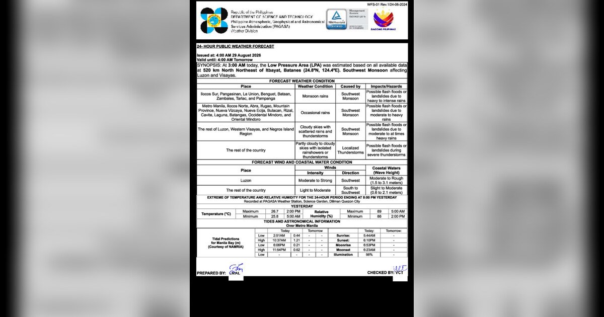
The Philippine Atmospheric, Geophysical and Astronomical Services Administration (PAGASA) issued a nationwide advisory at 4:00 AM on August 29, 2026, valid through 4:00 AM the following day, August 30, 2026. The bulletin lays out a tiered picture of risk — highest in northern and central Luzon, moderate across the rest of the main island and the western Visayas, and lowest but not negligible across Mindanao and the remaining regions of the archipelago.
The Two Systems Behind Friday’s Weather
PAGASA identified two distinct but interacting weather drivers shaping conditions across the Philippines on Friday.
The first is a Low Pressure Area (LPA). As of 3:00 AM Friday, the weather bureau placed the system approximately 520 kilometers north-northeast of Itbayat, Batanes, at coordinates 24.8°N, 124.4°E. An LPA is a zone of reduced atmospheric pressure that pulls surrounding air inward, generating upward motion, cloud formation, and precipitation. PAGASA noted that while the LPA has not developed into a tropical cyclone, it is close enough to northern Luzon to funnel additional moisture into the area and intensify rainfall.
The second driver is the southwest monsoon, known locally as the habagat. This seasonal wind pattern, active from roughly June through September each year, channels warm, moisture-heavy air from the southwest across the Philippine archipelago. When the habagat interacts with a nearby LPA, its rainfall-producing capacity increases substantially — especially along the western flanks of Luzon and across the Visayas. According to PAGASA, that is exactly the combination now playing out.
By the Numbers
- 520 km — distance of the LPA north-northeast of Itbayat, Batanes, as of 3:00 AM August 29, 2026
- 15–30 mm per hour or more — rainfall rate classified as heavy to intense, enough to cause rapid river rises and slope instability
- 4:00 AM, August 30, 2026 — end time of PAGASA’s advisory validity period
- 24.8°N, 124.4°E — estimated coordinates of the LPA at 3:00 AM Friday
Where the Heaviest Rain Is Falling
Northern and Central Luzon: Highest Risk Zones
The areas facing the most dangerous conditions on Friday span a broad swath of northern and central Luzon. PAGASA forecasts heavy to intense rainfall — defined as precipitation falling at 15 to 30 millimeters per hour or faster — for several clusters of provinces.
The southwest monsoon’s direct impact is expected to produce the worst rain in Ilocos Sur, La Union, Pangasinan, Benguet, Bontoc, Tarlac, and Nueva Vizcaya. The weather bureau explicitly listed flooding and landslides as potential outcomes in these areas. Communities in the Ilocos Region and the Cordillera Administrative Region face elevated landslide risk due to their mountainous terrain, while those near rivers and low-lying areas should monitor water levels closely.
A second group of provinces is under a similarly elevated threat. Ilocos Norte, Abra, Nueva Ecija, Bulacan, Pampanga, and adjoining areas are also being lashed by the southwest monsoon, with heavy rain and risks of localized flooding and landslides, according to the PAGASA advisory.
Rest of Luzon, Western Visayas, and Negros Island Region: Monsoon Showers and Thunderstorms
Areas outside the highest-risk belt — including the rest of Luzon, the western Visayas, and the Negros Island Region — are forecast to experience cloudy skies with scattered rain showers and thunderstorms, also attributable to the southwest monsoon. PAGASA warned that rainfall in these zones may turn moderate to heavy at times, creating real but lower-level flood risk. Residents in these areas should not treat the relatively lower classification as an all-clear signal.
Mindanao and Remaining Areas: Isolated Afternoon Thunderstorms
For Mindanao and the parts of the country not covered by the two higher-risk categories, PAGASA’s forecast calls for partly cloudy to cloudy skies with isolated rain showers or thunderstorms. The weather bureau attributed these to local thunderstorm activity rather than the monsoon itself. The risk is comparatively low, but afternoon convective thunderstorms remain possible — especially over inland areas and elevated terrain — and residents should remain weather-aware through the day.
Wind Conditions and Sea State
Beyond rainfall, PAGASA’s Friday advisory also addresses wind and coastal water conditions — a significant concern for fisherfolk and maritime workers.
Over Luzon, winds are expected to blow moderate to strong from the southwest, and coastal waters are described as moderate to rough. The weather bureau’s characterization of rough seas means wave heights are high enough to capsize or swamp small and medium-sized watercraft, making it dangerous for fishing boats and bancas to venture out along Luzon’s western and northern coastlines.
Conditions are somewhat less severe across the Visayas, where PAGASA forecasts light to moderate southwest winds and slight to moderate coastal waters. While more manageable than in Luzon, the sea state still demands caution from small-boat operators. The rest of the country, including Mindanao, will see light to moderate winds and slight to moderate seas.
Practical Guidance for Those Affected
Commuters and Motorists
Travelers passing through northern and central Luzon on Friday — including those crossing the Ilocos Region, the Cordillera, Central Luzon, and the Cagayan Valley — should anticipate sustained rainfall throughout the day and the possibility of road closures triggered by flooding or landslides. Authorities advise giving extra travel time, steering clear of underpasses and flood-prone roads during heavy downpours, and checking local government advisories before departing. Even in Metro Manila, which falls under the lower-risk “rest of Luzon” category, wet roads and reduced visibility during rain bursts should be expected.
Fisherfolk and Coastal Communities
PAGASA’s assessment of moderate to rough seas off Luzon represents a serious warning for those whose livelihoods depend on the water. Small fishing vessels and bancas are strongly advised not to put out to sea along Luzon’s western and northern coasts on Friday. Those operating in Visayan waters face more moderate but still requiring cautious conditions. The weather bureau recommends waiting for updated bulletins and consulting the Philippine Coast Guard before making any decision to sail.
Farmers in Affected Provinces
Agricultural workers in high-risk provinces such as Ilocos Sur, Pangasinan, Benguet, and neighboring areas face the threat of flash flooding in low-lying fields and potential landslides disrupting farm roads. PAGASA’s data on the intensity of expected rainfall underscores the need to secure farm equipment and livestock where feasible, and to avoid working on steep or unstable slopes while conditions remain dangerous.
Understanding What “Heavy to Intense” Really Means
For those unfamiliar with how PAGASA classifies rainfall, the agency defines heavy to intense rain as precipitation falling at 15 to 30 millimeters per hour or more — fast enough for rivers to rise rapidly and for saturated hillsides to become unstable. Residents in high-risk areas near rivers, creeks, or slopes should be prepared to relocate quickly to higher ground if water begins rising. Meanwhile, scattered thunderstorms across the broader Luzon and Visayas areas carry a genuine lightning risk for anyone outdoors; PAGASA consistently advises seeking shelter inside solid structures — not under trees — when thunder is audible.
Why This Matters
The simultaneous activation of a Low Pressure Area and the southwest monsoon creates compounding rainfall hazards across a densely populated stretch of the Philippines, placing lives, infrastructure, and agricultural areas at heightened risk of flooding and landslides on August 29, 2026. PAGASA’s advisory covers a wide arc of Luzon provinces where mountainous terrain makes landslides particularly destructive and recovery difficult. Maritime communities face an additional layer of danger through rough coastal waters, meaning both inland and coastal residents must heed the weather bureau’s guidance to avoid preventable casualties.
Source: Originally reported by breakingnewsnegrosoriental.com / PAGASA 4:00 AM Advisory, August 29, 2026