DUMAGUETE CITY, Negros Oriental — October 13, 2026: The Philippine Atmospheric, Geophysical and Astronomical Services Administration (PAGASA) has placed Negros Oriental under a thunderstorm and rainshower outlook for the entire 24-hour period beginning 5:00 AM Tuesday, covering both daytime and overnight hours, with no letup expected between the two forecast windows.
PAGASA’s Official Forecast at a Glance
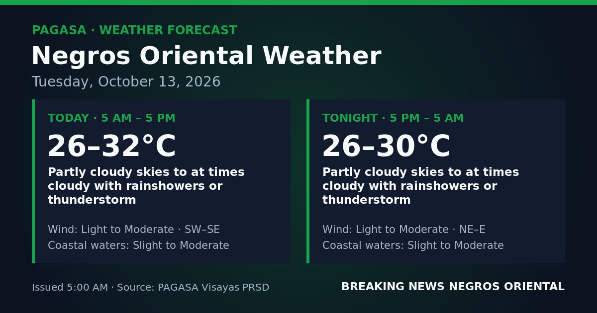
Issued at 5:00 AM on October 13, 2026, PAGASA’s Visayas regional forecast describes partly cloudy skies with intervals of cloudiness across Negros Oriental, accompanied by rainshowers or thunderstorms at any point during the day or night. According to PAGASA, no tropical cyclone wind signals, gale warnings, or rainfall advisories are in effect for the province or the broader Visayas region — the concern today is persistent shower and thunderstorm risk rather than an approaching severe weather event.
PAGASA’s bulletin does not name a specific weather system — such as the northeast monsoon, southwest monsoon, or a low-pressure area — as the cause of today’s conditions. The agency describes the weather pattern without attributing it to a named driver, and only what the official forecast states is reflected here.
Wind Shift Between Day and Night
One notable feature in PAGASA’s forecast is a change in wind direction between the two periods. Daytime winds will blow from the southwest to southeast, while overnight winds are expected to shift to the northeast to east — both at light to moderate strength. PAGASA has not identified a named system behind this shift, but the change can indicate transitional atmospheric conditions commonly associated with variable shower activity. Residents are advised to monitor official PAGASA updates for any developments.
Daytime Period: 5:00 AM to 5:00 PM
During daylight hours, PAGASA forecasts temperatures in Negros Oriental ranging from 26°C to 32°C. Winds from the southwest to southeast will blow at light to moderate strength — noticeable but not destructive. Coastal waters surrounding the province, including areas off Dumaguete, Bayawan, and the Tañon Strait, are forecast at slight to moderate — meaning wave heights could reach anywhere from 0.5 meters up to 2.5 meters depending on actual conditions at the time.
Overnight Period: 5:00 PM to 5:00 AM (October 14)
The thunderstorm risk carries through the night. PAGASA forecasts continued rainshowers or thunderstorms overnight, with temperatures easing slightly to a range of 26°C to 30°C. Wind direction shifts to northeast to east, still at light to moderate strength, and coastal waters remain at slight to moderate. Low-lying and flood-prone barangays — including areas in Dumaguete City, Bais, and Bayawan — face an elevated risk of rapid water-level rises overnight, particularly if drainage systems are already taxed from daytime rainfall, according to the forecast pattern PAGASA describes.
By the Numbers
- Forecast period starts: 5:00 AM, October 13, 2026
- Daytime temperature range: 26°C – 32°C
- Overnight temperature range: 26°C – 30°C
- Daytime wind direction: Southwest to Southeast
- Overnight wind direction: Northeast to East
- Slight seas wave height: 0.5 – 1.25 meters
- Moderate seas wave height: 1.25 – 2.5 meters
What “Slight to Moderate” Seas Mean in Practice
PAGASA uses standardised sea-state categories that are worth clarifying. Slight seas — wave heights of roughly 0.5 to 1.25 meters — are generally manageable for large inter-island ferries, though passengers may feel movement. Small fishing bancas and open outrigger boats face a real risk of swamping in open water even under these conditions. Moderate seas, with wave heights climbing toward 1.25 to 2.5 meters, present greater difficulty: fast-craft operators may consider delays or cancellations, and small vessels should not be at sea.
Because PAGASA’s forecast covers slight to moderate — meaning conditions could reach either end of that range — fisherfolk, ferry operators, and passengers on routes between Dumaguete, Cebu, and Siquijor should use the higher end as their planning benchmark. PAGASA strongly advises small boat operators to exercise caution and to stay close to shore if they do venture out, returning immediately if skies darken or thunder is heard.
Guidance by Sector
Fisherfolk and Small-Boat Operators
The combination of slight-to-moderate seas and potential thunderstorms makes conditions high-risk for small vessels today. PAGASA’s advisory strongly urges small boat operators to take precautions, as lightning at sea and sudden squalls associated with thunderstorms can worsen conditions with very little warning. These risks apply equally to overnight operations.
Ferry Passengers
Those travelling through Dumaguete port — whether heading to Cebu, Siquijor, or other inter-island destinations — should confirm departure status with their ferry operator before proceeding to the pier. Slight-to-moderate seas can lead to delays or cancellations, particularly for smaller fast-craft services. Travellers should build extra time into their schedules and prepare for possible route disruptions.
Motorists and Land Commuters
Rain bursts associated with thunderstorms can reduce visibility sharply and leave road surfaces slippery. Mountain roads linking Dumaguete with interior areas such as Guihulngan require extra caution during and after heavy rainfall. Drivers are advised to slow down and increase following distance during rain episodes.
Farmers and Agricultural Workers
Workers in open fields — particularly those in elevated areas and upland barangays — face a genuine lightning hazard during thunderstorm development. PAGASA’s forecast of intermittent rainshowers also raises the risk of soil erosion on sloped farmland during sudden heavy bursts. Those working in the uplands of Guihulngan and La Libertad are advised to monitor sky conditions throughout the day and seek sturdy shelter immediately when thunderstorms approach.
Students and Schools
Parents are advised to send children to school equipped with rain gear, as thunderstorms can develop rapidly. School administrators in areas prone to flash flooding should monitor conditions through the school day and be prepared to act if prolonged heavy rain occurs, consistent with PAGASA’s thunderstorm forecast for the province.
Why This Matters
According to PAGASA, thunderstorms in this region can develop quickly and produce flash flooding in low-lying areas and drainage-prone streets, and pose real danger to those on the water — making the agency’s call for caution relevant to fisherfolk, ferry passengers, road users, and residents in flood-prone barangays throughout the province.
Source: Breaking News Negros Oriental (breakingnewsnegrosoriental.com)